Bellwood Topo Map Tennessee
To zoom in, hover over the map of Bellwood
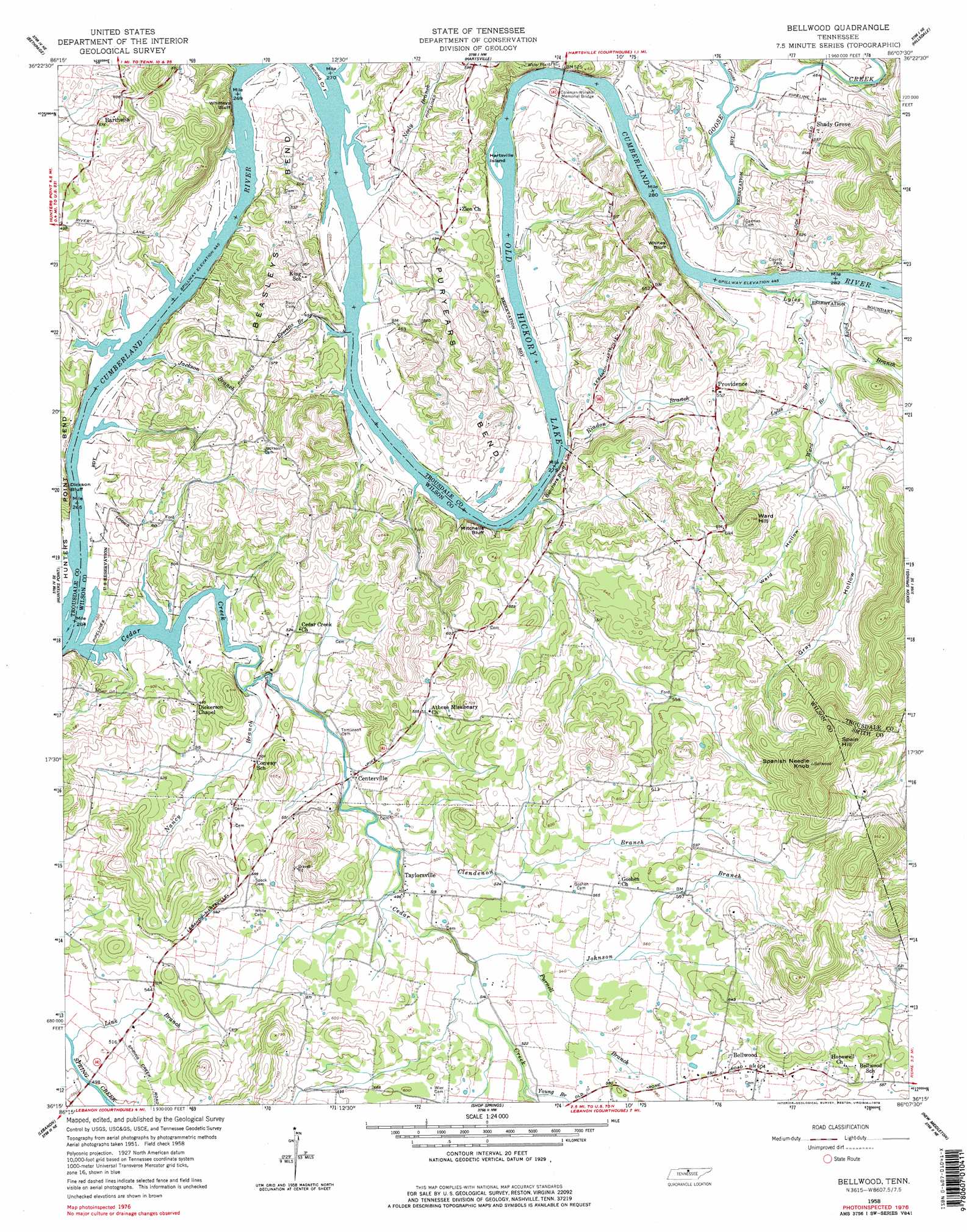
USGS Topo Quad 36086c2 - 1:24,000 scale
| Topo Map Name: | Bellwood |
| USGS Topo Quad ID: | 36086c2 |
| Print Size: | ca. 21 1/4" wide x 27" high |
| Southeast Coordinates: | 36.25° N latitude / 86.125° W longitude |
| Map Center Coordinates: | 36.3125° N latitude / 86.1875° W longitude |
| U.S. State: | TN |
| Filename: | o36086c2.jpg |
| Download Map JPG Image: | Bellwood topo map 1:24,000 scale |
| Map Type: | Topographic |
| Topo Series: | 7.5´ |
| Map Scale: | 1:24,000 |
| Source of Map Images: | United States Geological Survey (USGS) |
| Alternate Map Versions: |
Bellwood TN 1958, updated 1959 Download PDF Buy paper map Bellwood TN 1958, updated 1978 Download PDF Buy paper map Bellwood TN 1958, updated 1978 Download PDF Buy paper map Bellwood TN 1994, updated 1997 Download PDF Buy paper map Bellwood TN 2010 Download PDF Buy paper map Bellwood TN 2013 Download PDF Buy paper map Bellwood TN 2016 Download PDF Buy paper map |
1:24,000 Topo Quads surrounding Bellwood
Fountain Head |
Turners Station |
Westmoreland |
Lafayette |
Galen |
Gallatin |
Bethpage |
Hartsville |
Hillsdale |
Pleasant Shade |
Laguardo |
Hunters Point |
Bellwood |
Dixon Springs |
Carthage |
Martha |
Lebanon |
Shop Springs |
New Middleton |
Gordonsville |
Gladeville |
Vine |
Watertown |
Alexandria |
Liberty |
> Back to 36086a1 at 1:100,000 scale
> Back to 36086a1 at 1:250,000 scale
> Back to U.S. Topo Maps home
Bellwood topo map: Gazetteer
Bellwood: Bars
Berdine Bar elevation 136m 446′Goose Creek Bar elevation 136m 446′
Mills Island Bar elevation 136m 446′
Sampson Shoals elevation 136m 446′
Bellwood: Bends
Beasleys Bend elevation 159m 521′Puryears Bend elevation 179m 587′
Bellwood: Bridges
Coleman-Winston Memorial Bridge elevation 136m 446′Bellwood: Cliffs
Belchers Bluff elevation 136m 446′Dickson Bluff elevation 166m 544′
Mitchells Bluff elevation 143m 469′
Whites Bluff elevation 166m 544′
Whitleys Bluff elevation 144m 472′
Bellwood: Dams
Old Lock and Dam Number Five (historical) elevation 136m 446′Old Lock and Dam Number Six (historical) elevation 136m 446′
Bellwood: Islands
Cedar Creek Island elevation 136m 446′Goose Creek Island (historical) elevation 136m 446′
Hartsville Island elevation 137m 449′
Mills Island elevation 140m 459′
Second Creek Island elevation 137m 449′
Whitleys Island elevation 136m 446′
Bellwood: Parks
Dickson Chapel Recreation Area elevation 136m 446′Hartsville Access Area elevation 140m 459′
Shady Grove Access Area elevation 138m 452′
Trousdale County Park elevation 159m 521′
Bellwood: Populated Places
Bellwood elevation 187m 613′Centerville elevation 146m 479′
Dixon (historical) elevation 152m 498′
Providence elevation 169m 554′
Shady Grove elevation 152m 498′
Taylorsville elevation 152m 498′
Weir (historical) elevation 159m 521′
Bellwood: Streams
Cedar Creek elevation 136m 446′Clendenon Branch elevation 146m 479′
Clifford Branch elevation 144m 472′
Douglas Branch elevation 136m 446′
Everetts Branch elevation 136m 446′
Foley Branch elevation 140m 459′
Goose Creek elevation 140m 459′
Jackson Branch elevation 136m 446′
Johnson Branch elevation 152m 498′
Link Branch elevation 152m 498′
Little Goose Creek elevation 137m 449′
Lyles Creek elevation 136m 446′
Nancy Branch elevation 137m 449′
Neely Branch elevation 136m 446′
Purnell Branch elevation 157m 515′
Riadon Branch elevation 136m 446′
Stone Branch elevation 141m 462′
Ward Branch elevation 141m 462′
Young Branch elevation 158m 518′
Bellwood: Summits
Spanish Needle Knob elevation 331m 1085′Ward Hill elevation 240m 787′
Bellwood: Valleys
Gray Hollow elevation 153m 501′Bellwood digital topo map on disk
Buy this Bellwood topo map showing relief, roads, GPS coordinates and other geographical features, as a high-resolution digital map file on DVD: