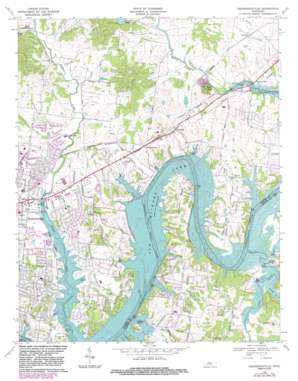
Hendersonville Topo Map Tennessee
To zoom in, hover over the map of Hendersonville
USGS Topo Quad 36086c5 - 1:24,000 scale
| Topo Map Name: | Hendersonville |
| USGS Topo Quad ID: | 36086c5 |
| Print Size: | ca. 21 1/4" wide x 27" high |
| Southeast Coordinates: | 36.25° N latitude / 86.5° W longitude |
| Map Center Coordinates: | 36.3125° N latitude / 86.5625° W longitude |
| U.S. State: | TN |
| Filename: | o36086c5.jpg |
| Download Map JPG Image: | Hendersonville topo map 1:24,000 scale |
| Map Type: | Topographic |
| Topo Series: | 7.5´ |
| Map Scale: | 1:24,000 |
| Source of Map Images: | United States Geological Survey (USGS) |
| Alternate Map Versions: |
Hendersonville TN 1952, updated 1953 Download PDF Buy paper map Hendersonville TN 1957, updated 1959 Download PDF Buy paper map Hendersonville TN 1968, updated 1971 Download PDF Buy paper map Hendersonville TN 1968, updated 1983 Download PDF Buy paper map Hendersonville TN 2010 Download PDF Buy paper map Hendersonville TN 2013 Download PDF Buy paper map Hendersonville TN 2016 Download PDF Buy paper map |
1:24,000 Topo Quads surrounding Hendersonville
> Back to 36086a1 at 1:100,000 scale
> Back to 36086a1 at 1:250,000 scale
> Back to U.S. Topo Maps home
Hendersonville topo map: Gazetteer
Hendersonville: Bends
Cages Bend elevation 159m 521′Lindsley Bend elevation 158m 518′
Hendersonville: Crossings
Benders Ferry (historical) elevation 136m 446′Sanders Ford (historical) elevation 136m 446′
Saundersville Ferry (historical) elevation 136m 446′
Hendersonville: Dams
Five Coves Dam elevation 147m 482′Norman Lake Dam elevation 161m 528′
Hendersonville: Islands
Harbour Island elevation 154m 505′Lindsley Islands (historical) elevation 136m 446′
Hendersonville: Lakes
Crutcher Lake elevation 174m 570′Hendersonville: Parks
Avondale Access Area elevation 136m 446′Cages Bend Access Area elevation 136m 446′
Cages Bend Recreation Area elevation 144m 472′
Cedar Creek Access Area elevation 138m 452′
Drakes Creek Park elevation 138m 452′
Hendersonville Park elevation 140m 459′
Lone Branch Access Area elevation 138m 452′
Saunders Ferry Park elevation 140m 459′
Saundersville Access Area elevation 145m 475′
Stark Knob Access Area elevation 142m 465′
Twitty City-Music Village USA elevation 166m 544′
Hendersonville: Populated Places
Avondale elevation 172m 564′Bluegrass Meadows elevation 160m 524′
Cedar Grove elevation 177m 580′
Cherokee Woods elevation 146m 479′
Colonial Acres elevation 145m 475′
Creekwood Estates elevation 154m 505′
Cumberland Hills elevation 159m 521′
Curtiswood elevation 146m 479′
Glen Oaks elevation 151m 495′
Hendersonville elevation 147m 482′
Indian Forest elevation 143m 469′
Indian Lake Forest elevation 158m 518′
Lake Club Estates elevation 146m 479′
Lakeside Park elevation 150m 492′
Lindsley (historical) elevation 156m 511′
Maple Row Estates elevation 164m 538′
Meadowvale elevation 148m 485′
Nokes Heights elevation 144m 472′
Nonaville elevation 153m 501′
Oakvale elevation 146m 479′
Owen Estates elevation 157m 515′
Peytona elevation 161m 528′
Point O'View elevation 153m 501′
Raintree Estates elevation 150m 492′
Rosewood elevation 153m 501′
Sarah Berry Annex elevation 146m 479′
Saundersville elevation 171m 561′
Scottish Highlands elevation 166m 544′
Shackle Island elevation 158m 518′
The Maples elevation 159m 521′
Walnut Hills Estates elevation 145m 475′
Hendersonville: Reservoirs
Five Coves Lake elevation 147m 482′Norman Lake elevation 161m 528′
Hendersonville: Streams
Cedar Creek elevation 136m 446′Hays Branch elevation 136m 446′
Little Creek elevation 136m 446′
Lone Branch elevation 136m 446′
Smith Branch elevation 136m 446′
Hendersonville: Summits
Fort Hill elevation 159m 521′Pilot Knob elevation 231m 757′
Hendersonville digital topo map on disk
Buy this Hendersonville topo map showing relief, roads, GPS coordinates and other geographical features, as a high-resolution digital map file on DVD:


