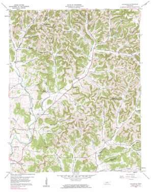
Hillsdale Topo Map Tennessee
To zoom in, hover over the map of Hillsdale
USGS Topo Quad 36086d1 - 1:24,000 scale
| Topo Map Name: | Hillsdale |
| USGS Topo Quad ID: | 36086d1 |
| Print Size: | ca. 21 1/4" wide x 27" high |
| Southeast Coordinates: | 36.375° N latitude / 86° W longitude |
| Map Center Coordinates: | 36.4375° N latitude / 86.0625° W longitude |
| U.S. State: | TN |
| Filename: | o36086d1.jpg |
| Download Map JPG Image: | Hillsdale topo map 1:24,000 scale |
| Map Type: | Topographic |
| Topo Series: | 7.5´ |
| Map Scale: | 1:24,000 |
| Source of Map Images: | United States Geological Survey (USGS) |
| Alternate Map Versions: |
Hillsdale TN 1959, updated 1960 Download PDF Buy paper map Hillsdale TN 1959, updated 1984 Download PDF Buy paper map Hillsdale TN 1994, updated 1997 Download PDF Buy paper map Hillsdale TN 2010 Download PDF Buy paper map Hillsdale TN 2013 Download PDF Buy paper map Hillsdale TN 2016 Download PDF Buy paper map |
1:24,000 Topo Quads surrounding Hillsdale
> Back to 36086a1 at 1:100,000 scale
> Back to 36086a1 at 1:250,000 scale
> Back to U.S. Topo Maps home
Hillsdale topo map: Gazetteer
Hillsdale: Populated Places
Beech Bottom elevation 188m 616′Beech Grove elevation 155m 508′
Beech Hill elevation 186m 610′
Cato elevation 154m 505′
Hillsdale elevation 165m 541′
Horsleys elevation 167m 547′
Meadorville elevation 181m 593′
New Harmony elevation 197m 646′
Pleasant Valley elevation 162m 531′
Hillsdale: Ridges
Peddlers Ridge elevation 304m 997′Hillsdale: Streams
Barbers Branch elevation 185m 606′Carr Creek elevation 167m 547′
Carter Branch elevation 157m 515′
Dark Shrum Branch elevation 187m 613′
Dog Branch elevation 155m 508′
Dry Branch elevation 163m 534′
Dry Fork elevation 170m 557′
Echo Creek elevation 160m 524′
Finley Branch elevation 146m 479′
Ford Branch elevation 170m 557′
Gaulden Branch elevation 183m 600′
Haynie Branch elevation 141m 462′
Hickerson Branch elevation 147m 482′
Holder Branch elevation 152m 498′
Honey Prong elevation 172m 564′
Middle Fork Goose Creek elevation 146m 479′
North Fork Scanty Branch elevation 171m 561′
Parker Branch elevation 163m 534′
Pumpkin Branch elevation 157m 515′
Scanty Branch elevation 156m 511′
South Fork Young Branch elevation 157m 515′
Sullivan Branch elevation 171m 561′
Taylor Branch elevation 162m 531′
Hillsdale: Summits
Hard Scratch Hill elevation 317m 1040′Hillsdale: Valleys
Adamson Hollow elevation 183m 600′Blankenship Hollow elevation 164m 538′
Carman Hollow elevation 161m 528′
Cornwell Hollow elevation 175m 574′
Dark Hollow elevation 189m 620′
Deering Hollow elevation 188m 616′
Dillehay Hollow elevation 180m 590′
Evitts Hollow elevation 150m 492′
Ford Hollow elevation 205m 672′
Freeman Hollow elevation 183m 600′
Golden Hollow elevation 182m 597′
Greenwood Hollow elevation 168m 551′
Massey Hollow elevation 173m 567′
McClanahan Hollow elevation 157m 515′
McDonald Hollow elevation 192m 629′
Possum Hollow elevation 152m 498′
Sanders Hollow elevation 177m 580′
Short Hollow elevation 184m 603′
Suggs Hollow elevation 170m 557′
Thompson Hollow elevation 154m 505′
Woodmore Hollow elevation 157m 515′
Woodmore Hollow elevation 191m 626′
Wright Hollow elevation 190m 623′
Hillsdale digital topo map on disk
Buy this Hillsdale topo map showing relief, roads, GPS coordinates and other geographical features, as a high-resolution digital map file on DVD:


