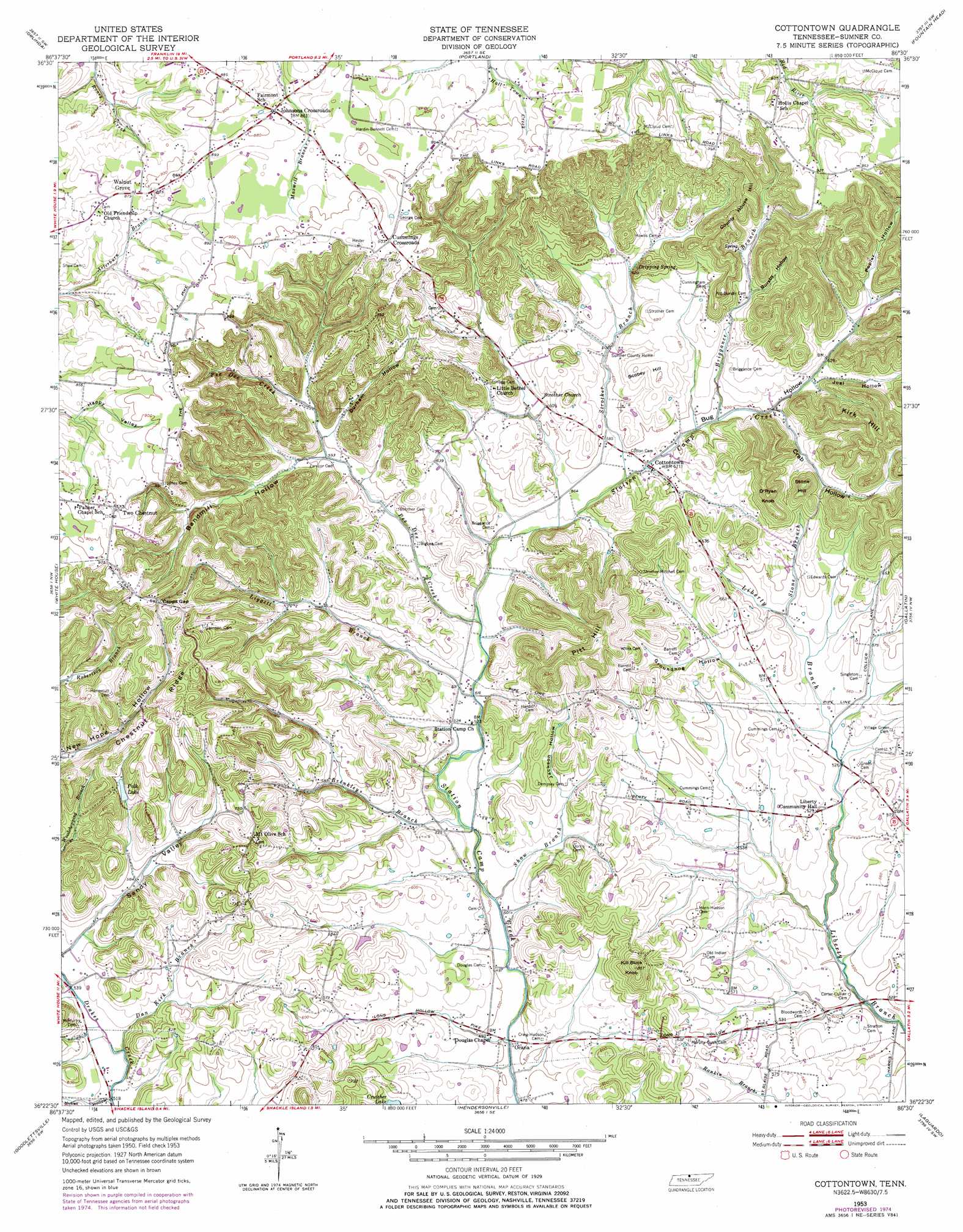
Cottontown Topo Map Tennessee
To zoom in, hover over the map of Cottontown
USGS Topo Quad 36086d5 - 1:24,000 scale
| Topo Map Name: | Cottontown |
| USGS Topo Quad ID: | 36086d5 |
| Print Size: | ca. 21 1/4" wide x 27" high |
| Southeast Coordinates: | 36.375° N latitude / 86.5° W longitude |
| Map Center Coordinates: | 36.4375° N latitude / 86.5625° W longitude |
| U.S. State: | TN |
| Filename: | o36086d5.jpg |
| Download Map JPG Image: | Cottontown topo map 1:24,000 scale |
| Map Type: | Topographic |
| Topo Series: | 7.5´ |
| Map Scale: | 1:24,000 |
| Source of Map Images: | United States Geological Survey (USGS) |
| Alternate Map Versions: |
Cottontown TN 1953, updated 1955 Download PDF Buy paper map Cottontown TN 1953, updated 1969 Download PDF Buy paper map Cottontown TN 1953, updated 1977 Download PDF Buy paper map Cottontown TN 1994, updated 1997 Download PDF Buy paper map Cottontown TN 2010 Download PDF Buy paper map Cottontown TN 2013 Download PDF Buy paper map Cottontown TN 2016 Download PDF Buy paper map |
1:24,000 Topo Quads surrounding Cottontown
Adairville |
Prices Mill |
Franklin |
Hickory Flat |
Adolphus |
Youngville |
Orlinda |
Portland |
Fountain Head |
Turners Station |
Greenbrier |
White House |
Cottontown |
Gallatin |
Bethpage |
Whites Creek |
Goodlettsville |
Hendersonville |
Laguardo |
Hunters Point |
Nashville West |
Nashville East |
Hermitage |
Martha |
Lebanon |
> Back to 36086a1 at 1:100,000 scale
> Back to 36086a1 at 1:250,000 scale
> Back to U.S. Topo Maps home
Cottontown topo map: Gazetteer
Cottontown: Dams
Crutcher Lake Dam elevation 174m 570′Cottontown: Gaps
Capps Gap elevation 269m 882′Cottontown: Mines
Gillespie Prospect elevation 191m 626′Robertson Prospect elevation 197m 646′
Webb Prospect elevation 178m 583′
Cottontown: Populated Places
Cottontown elevation 174m 570′Cummings Crossroads elevation 275m 902′
Johnsons Crossroads elevation 260m 853′
Ocana elevation 147m 482′
Rival (historical) elevation 147m 482′
Station Camp (historical) elevation 153m 501′
Two Chestnut elevation 276m 905′
Walnut Grove elevation 270m 885′
Cottontown: Post Offices
Cottontown Post Office elevation 176m 577′Cottontown: Reservoirs
Crutcher Lake elevation 174m 570′Polk Lake elevation 210m 688′
Cottontown: Ridges
Chestnut Ridge elevation 258m 846′Cottontown: Springs
Dripping Spring elevation 194m 636′Cottontown: Streams
Briggance Branch elevation 181m 593′Brinkley Branch elevation 157m 515′
Dan Kirk Branch elevation 159m 521′
Liggett Branch elevation 158m 518′
Pee Dee Creek elevation 164m 538′
Shaw Branch elevation 152m 498′
Stone Branch elevation 170m 557′
Strother Branch elevation 171m 561′
Cottontown: Summits
County House Hill elevation 275m 902′Kill Buck Knob elevation 257m 843′
Kirk Hill elevation 275m 902′
O'Ryan Knob elevation 275m 902′
Pitt Hill elevation 281m 921′
Scobey Hill elevation 214m 702′
Stone Hill elevation 265m 869′
Cottontown: Valleys
Bandmill Hollow elevation 181m 593′Bug Hollow elevation 175m 574′
Bursby Hollow elevation 200m 656′
Crab Hollow elevation 185m 606′
Durham Hollow elevation 187m 613′
Groundhop Hollow elevation 181m 593′
Hutlet Hollow elevation 159m 521′
Jackson Hollow elevation 175m 574′
Joel Hollow elevation 189m 620′
Poplar Hollow elevation 200m 656′
Sandy Valley elevation 168m 551′
Cottontown digital topo map on disk
Buy this Cottontown topo map showing relief, roads, GPS coordinates and other geographical features, as a high-resolution digital map file on DVD: