White House Topo Map Tennessee
To zoom in, hover over the map of White House
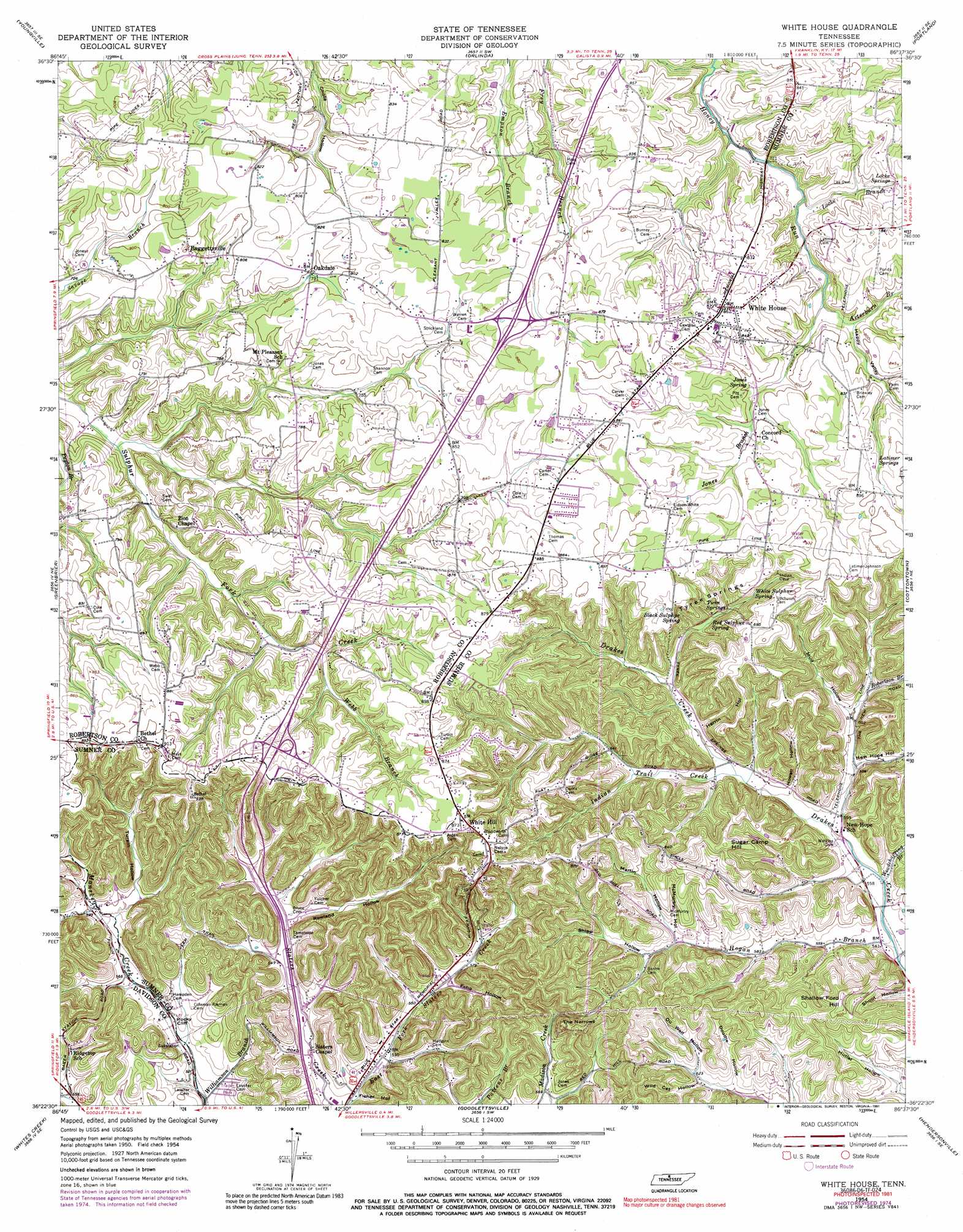
USGS Topo Quad 36086d6 - 1:24,000 scale
| Topo Map Name: | White House |
| USGS Topo Quad ID: | 36086d6 |
| Print Size: | ca. 21 1/4" wide x 27" high |
| Southeast Coordinates: | 36.375° N latitude / 86.625° W longitude |
| Map Center Coordinates: | 36.4375° N latitude / 86.6875° W longitude |
| U.S. State: | TN |
| Filename: | o36086d6.jpg |
| Download Map JPG Image: | White House topo map 1:24,000 scale |
| Map Type: | Topographic |
| Topo Series: | 7.5´ |
| Map Scale: | 1:24,000 |
| Source of Map Images: | United States Geological Survey (USGS) |
| Alternate Map Versions: |
White House TN 1954, updated 1955 Download PDF Buy paper map White House TN 1954, updated 1973 Download PDF Buy paper map White House TN 1954, updated 1977 Download PDF Buy paper map White House TN 1954, updated 1991 Download PDF Buy paper map White House TN 2010 Download PDF Buy paper map White House TN 2013 Download PDF Buy paper map White House TN 2016 Download PDF Buy paper map |
1:24,000 Topo Quads surrounding White House
Dot |
Adairville |
Prices Mill |
Franklin |
Hickory Flat |
Springfield North |
Youngville |
Orlinda |
Portland |
Fountain Head |
Springfield South |
Greenbrier |
White House |
Cottontown |
Gallatin |
Forest Grove |
Whites Creek |
Goodlettsville |
Hendersonville |
Laguardo |
Scottsboro |
Nashville West |
Nashville East |
Hermitage |
Martha |
> Back to 36086a1 at 1:100,000 scale
> Back to 36086a1 at 1:250,000 scale
> Back to U.S. Topo Maps home
White House topo map: Gazetteer
White House: Cliffs
Rocky Cliff elevation 169m 554′White House: Crossings
Interchange 104 elevation 263m 862′Interchange 108 elevation 259m 849′
White House: Gaps
The Narrows elevation 243m 797′White House: Parks
White House City Park elevation 267m 875′White House: Populated Places
Baggettsville elevation 236m 774′Mims (historical) elevation 187m 613′
Oakdale elevation 243m 797′
Peaceful Acres elevation 251m 823′
Rolling Acres elevation 268m 879′
Tyree Springs (historical) elevation 265m 869′
White Hill elevation 264m 866′
White House elevation 263m 862′
White House: Post Offices
White House Post Office elevation 263m 862′White House: Springs
Black Sulphur Spring elevation 220m 721′Jones Spring elevation 238m 780′
Latimer Springs elevation 260m 853′
Locke Springs elevation 242m 793′
Red Sulphur Spring elevation 205m 672′
Twin Springs elevation 213m 698′
Tyree Springs elevation 223m 731′
White Sulphur Spring elevation 217m 711′
White House: Streams
Arterburn Branch elevation 226m 741′Hogan Branch elevation 164m 538′
Indian Trail Creek elevation 178m 583′
Jones Branch elevation 239m 784′
Locke Branch elevation 217m 711′
Mill Branch elevation 197m 646′
Moss Branch elevation 201m 659′
Robertson Branch elevation 189m 620′
Webb Branch elevation 223m 731′
Williamson Branch elevation 155m 508′
Woodchopping Branch elevation 168m 551′
White House: Summits
Shallow Ford Hill elevation 255m 836′Sugar Camp Hill elevation 263m 862′
White House: Valleys
Doodle Hollow elevation 187m 613′Echo Hollow elevation 171m 561′
Fisher Hollow elevation 155m 508′
Happy Valley elevation 229m 751′
Herrin Hollow elevation 198m 649′
Howell Hollow elevation 176m 577′
Martin Hollow elevation 194m 636′
McMurtry Hollow elevation 190m 623′
Mud Hollow elevation 184m 603′
New Hope Hollow elevation 177m 580′
Oil Well Hollow elevation 196m 643′
Rowland Hollow elevation 173m 567′
Shipp Hollow elevation 192m 629′
Shoot Hollow elevation 163m 534′
Turpin Hollow elevation 182m 597′
Wild Cat Hollow elevation 189m 620′
White House digital topo map on disk
Buy this White House topo map showing relief, roads, GPS coordinates and other geographical features, as a high-resolution digital map file on DVD: