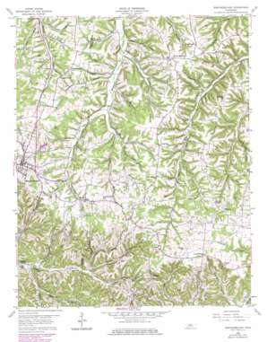
Westmoreland Topo Map Tennessee
To zoom in, hover over the map of Westmoreland
USGS Topo Quad 36086e2 - 1:24,000 scale
| Topo Map Name: | Westmoreland |
| USGS Topo Quad ID: | 36086e2 |
| Print Size: | ca. 21 1/4" wide x 27" high |
| Southeast Coordinates: | 36.5° N latitude / 86.125° W longitude |
| Map Center Coordinates: | 36.5625° N latitude / 86.1875° W longitude |
| U.S. State: | TN |
| Filename: | o36086e2.jpg |
| Download Map JPG Image: | Westmoreland topo map 1:24,000 scale |
| Map Type: | Topographic |
| Topo Series: | 7.5´ |
| Map Scale: | 1:24,000 |
| Source of Map Images: | United States Geological Survey (USGS) |
| Alternate Map Versions: |
Westmoreland TN 1958, updated 1959 Download PDF Buy paper map Westmoreland TN 1958, updated 1979 Download PDF Buy paper map Westmoreland TN 2010 Download PDF Buy paper map Westmoreland TN 2013 Download PDF Buy paper map Westmoreland TN 2016 Download PDF Buy paper map |
1:24,000 Topo Quads surrounding Westmoreland
> Back to 36086e1 at 1:100,000 scale
> Back to 36086a1 at 1:250,000 scale
> Back to U.S. Topo Maps home
Westmoreland topo map: Gazetteer
Westmoreland: Populated Places
Cross Lanes elevation 304m 997′Cross Roads elevation 281m 921′
Eulia elevation 294m 964′
Fairview elevation 311m 1020′
New Zion elevation 288m 944′
Pleasant Grove elevation 269m 882′
Rocky Mound elevation 289m 948′
Siloam elevation 274m 898′
Westmoreland elevation 282m 925′
Wixtown elevation 315m 1033′
Westmoreland: Springs
Buffalo Spring elevation 188m 616′Westmoreland: Streams
Davis Branch elevation 237m 777′Janey Branch elevation 213m 698′
Leaths Branch elevation 211m 692′
Morrison Branch elevation 219m 718′
Pop Branch elevation 207m 679′
Simmons Branch elevation 216m 708′
Tooley Branch elevation 235m 770′
Wix Branch elevation 255m 836′
Westmoreland: Valleys
Coleman Hollow elevation 260m 853′Copper Hollow elevation 245m 803′
Doss Hollow elevation 210m 688′
Gilliam Hollow elevation 221m 725′
Hawkins Hollow elevation 218m 715′
Henson Hollow elevation 211m 692′
Hicks Hollow elevation 211m 692′
Hoskins Hollow elevation 213m 698′
Leaths Chapel Hollow elevation 191m 626′
Leaths Hollow elevation 211m 692′
Mack Hollow elevation 215m 705′
Pearson Hollow elevation 194m 636′
Rouse Hollow elevation 224m 734′
Saltpeter Cave Hollow elevation 224m 734′
Sloan Hollow elevation 219m 718′
Stillhouse Hollow elevation 218m 715′
Sugar Camp Hollow elevation 213m 698′
Taylor Hollow elevation 201m 659′
Williams Hollow elevation 220m 721′
Westmoreland digital topo map on disk
Buy this Westmoreland topo map showing relief, roads, GPS coordinates and other geographical features, as a high-resolution digital map file on DVD:


