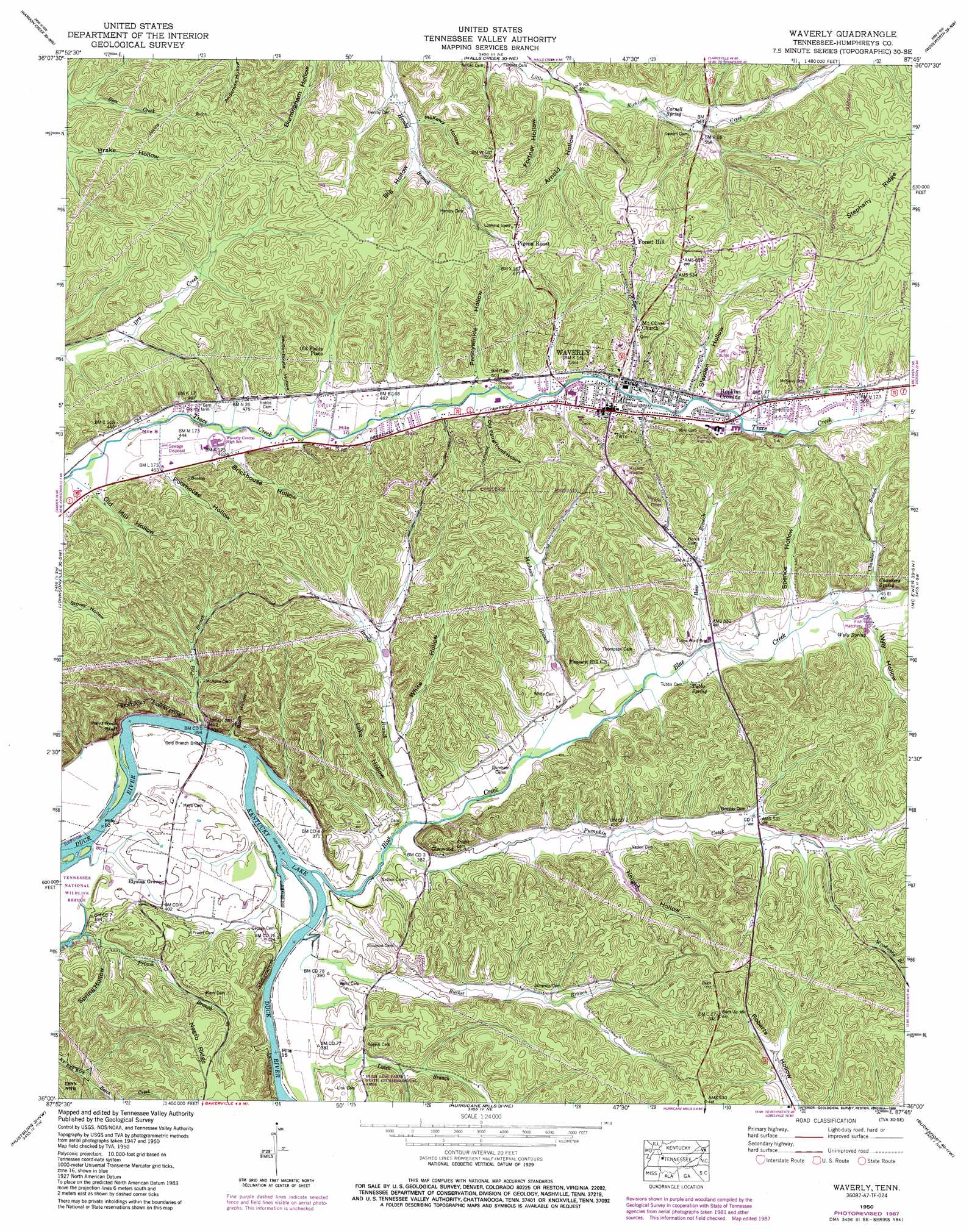
Waverly Topo Map Tennessee
To zoom in, hover over the map of Waverly
USGS Topo Quad 36087a7 - 1:24,000 scale
| Topo Map Name: | Waverly |
| USGS Topo Quad ID: | 36087a7 |
| Print Size: | ca. 21 1/4" wide x 27" high |
| Southeast Coordinates: | 36° N latitude / 87.75° W longitude |
| Map Center Coordinates: | 36.0625° N latitude / 87.8125° W longitude |
| U.S. State: | TN |
| Filename: | o36087a7.jpg |
| Download Map JPG Image: | Waverly topo map 1:24,000 scale |
| Map Type: | Topographic |
| Topo Series: | 7.5´ |
| Map Scale: | 1:24,000 |
| Source of Map Images: | United States Geological Survey (USGS) |
| Alternate Map Versions: |
Waverly TN 1936 Download PDF Buy paper map Waverly TN 1950, updated 1953 Download PDF Buy paper map Waverly TN 1950, updated 1970 Download PDF Buy paper map Waverly TN 1950, updated 1974 Download PDF Buy paper map Waverly TN 1950, updated 1988 Download PDF Buy paper map Waverly TN 2010 Download PDF Buy paper map Waverly TN 2013 Download PDF Buy paper map Waverly TN 2016 Download PDF Buy paper map |
1:24,000 Topo Quads surrounding Waverly
Poplar Creek |
Mckinnon |
Stewart |
Erin |
Ellis Mills |
Big Sandy |
Harmon Creek |
Halls Creek |
Woolworth |
Ruskin |
Camden |
Johnsonville |
Waverly |
Mcewen |
Tennessee City |
Rockport |
Hustburg |
Hurricane Mills |
Bucksnort |
Spot |
Sugar Tree |
Daniels Landing |
Lobelville |
Coble |
Whitfield |
> Back to 36087a1 at 1:100,000 scale
> Back to 36086a1 at 1:250,000 scale
> Back to U.S. Topo Maps home
Waverly topo map: Gazetteer
Waverly: Bars
Johnson Shoals elevation 109m 357′Waverly: Bridges
Cold Branch Bridge elevation 109m 357′Tubbs Ford Bridge elevation 128m 419′
Waverly: Cliffs
Paint Rock Bluff elevation 120m 393′Waverly: Parks
Hugh Link Farm State Archaeological Area elevation 133m 436′Waverly City Park elevation 190m 623′
Waverly: Populated Places
Elysian Grove elevation 122m 400′Forest Hill elevation 211m 692′
Glenwood elevation 121m 396′
Hopkins Crossing elevation 170m 557′
Old Fields Place elevation 165m 541′
Pigeon Roost elevation 208m 682′
Waverly elevation 163m 534′
Waverly: Post Offices
Waverly Post Office elevation 163m 534′Waverly: Ridges
Negro Ridge elevation 178m 583′Waverly: Springs
Carnell Spring elevation 158m 518′Chambers Spring elevation 143m 469′
Tubbs Spring elevation 143m 469′
Wyly Spring elevation 140m 459′
Waverly: Streams
Bear Branch elevation 126m 413′Blue Creek elevation 110m 360′
Brady Branch elevation 112m 367′
Bucket Branch elevation 110m 360′
Chambers Branch elevation 134m 439′
Cold Branch elevation 114m 374′
Mathews Branch elevation 117m 383′
Old Fields Place Branch elevation 139m 456′
Pumpkin Creek elevation 111m 364′
Waverly: Summits
Stairstep Hill elevation 195m 639′Waverly: Valleys
Arnold Hollow elevation 153m 501′Big Hollow elevation 159m 521′
Brickhouse Hollow elevation 142m 465′
Buck Hollow elevation 111m 364′
Fortner Hollow elevation 153m 501′
Knight Hollow elevation 135m 442′
Lake Hollow elevation 116m 380′
Matthews Hollow elevation 122m 400′
McKelvy Hollow elevation 156m 511′
Negro Hollow elevation 161m 528′
Old Fairground Hollow elevation 157m 515′
Old Mill Hollow elevation 136m 446′
Pennywinkle Hollow elevation 157m 515′
Poorhouse Hollow elevation 140m 459′
Sectionhouse Hollow elevation 147m 482′
Slayden Hollow elevation 166m 544′
Spence Hollow elevation 136m 446′
Spring Hollow elevation 113m 370′
Ussery Hollow elevation 153m 501′
White Hollow elevation 124m 406′
Wyly Hollow elevation 141m 462′
Waverly digital topo map on disk
Buy this Waverly topo map showing relief, roads, GPS coordinates and other geographical features, as a high-resolution digital map file on DVD: