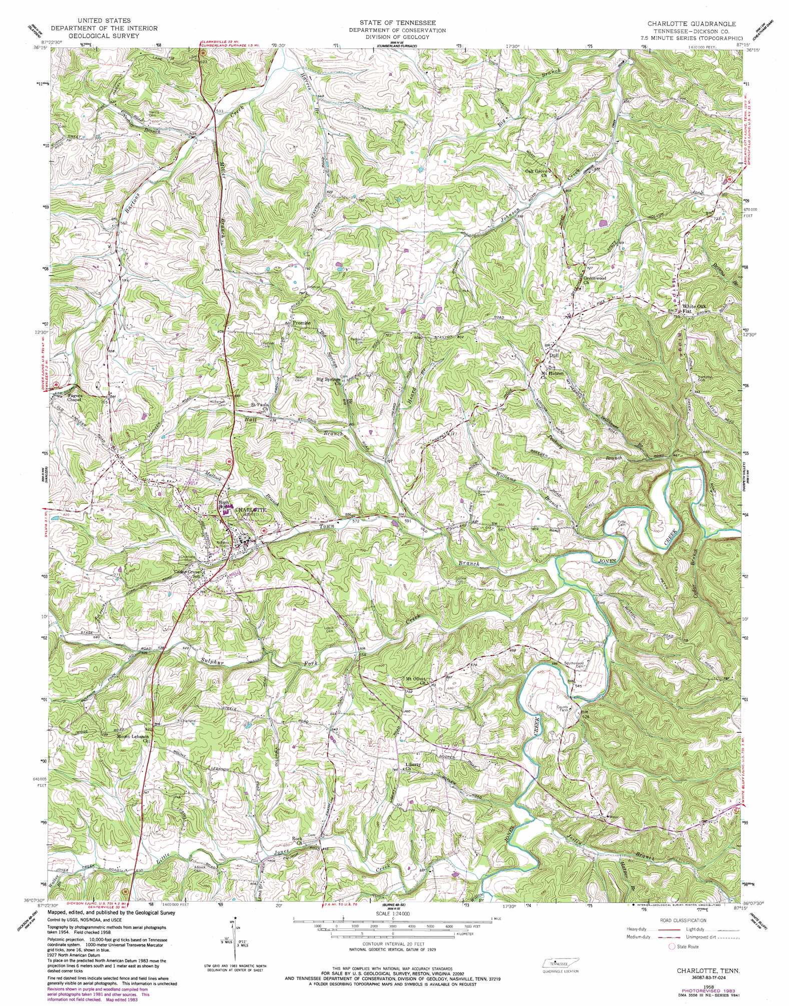
Charlotte Topo Map Tennessee
To zoom in, hover over the map of Charlotte
USGS Topo Quad 36087b3 - 1:24,000 scale
| Topo Map Name: | Charlotte |
| USGS Topo Quad ID: | 36087b3 |
| Print Size: | ca. 21 1/4" wide x 27" high |
| Southeast Coordinates: | 36.125° N latitude / 87.25° W longitude |
| Map Center Coordinates: | 36.1875° N latitude / 87.3125° W longitude |
| U.S. State: | TN |
| Filename: | o36087b3.jpg |
| Download Map JPG Image: | Charlotte topo map 1:24,000 scale |
| Map Type: | Topographic |
| Topo Series: | 7.5´ |
| Map Scale: | 1:24,000 |
| Source of Map Images: | United States Geological Survey (USGS) |
| Alternate Map Versions: |
Charlotte TN 1958, updated 1959 Download PDF Buy paper map Charlotte TN 1958, updated 1983 Download PDF Buy paper map Charlotte TN 2010 Download PDF Buy paper map Charlotte TN 2013 Download PDF Buy paper map Charlotte TN 2016 Download PDF Buy paper map |
1:24,000 Topo Quads surrounding Charlotte
Needmore |
Palmyra |
Excell |
Henrietta |
Pleasant View |
Ellis Mills |
Slayden |
Cumberland Furnace |
Cheatham Dam |
Ashland City |
Ruskin |
Vanleer |
Charlotte |
Harpeth Valley |
Lillamay |
Tennessee City |
Dickson |
Burns |
White Bluff |
Kingston Springs |
Spot |
Texas Hollow |
Lyles |
Craigfield |
Fairview |
> Back to 36087a1 at 1:100,000 scale
> Back to 36086a1 at 1:250,000 scale
> Back to U.S. Topo Maps home
Charlotte topo map: Gazetteer
Charlotte: Mines
Ore Bank Hill Prospect elevation 233m 764′South Charlotte Mine elevation 240m 787′
Charlotte: Populated Places
Belleview elevation 179m 587′Big Springs elevation 189m 620′
Charlotte elevation 198m 649′
Dull elevation 226m 741′
Greenwood elevation 221m 725′
Harris Hollow elevation 177m 580′
Mount Lebanon elevation 233m 764′
Promise elevation 251m 823′
Sweet Home elevation 162m 531′
White Oak Flat elevation 224m 734′
Charlotte: Streams
Big Springs Branch elevation 176m 577′Cedar Branch elevation 137m 449′
Gafford Branch elevation 140m 459′
Hall Branch elevation 158m 518′
Harper Branch elevation 170m 557′
Harris Branch elevation 155m 508′
Heard Branch elevation 170m 557′
Joslin Branch elevation 158m 518′
Leech Branch elevation 181m 593′
Little Jones Creek elevation 164m 538′
Matlock Branch elevation 177m 580′
Miller Branch elevation 158m 518′
Nesbitt Branch elevation 161m 528′
Peabody Branch elevation 140m 459′
Stillhouse Branch elevation 146m 479′
Sulphur Fork Creek elevation 148m 485′
Sweetwater Branch elevation 189m 620′
Town Branch elevation 147m 482′
Walker Branch elevation 193m 633′
Williams Branch elevation 145m 475′
Willow Branch elevation 168m 551′
Charlotte: Valleys
Harris Hollow elevation 158m 518′Charlotte digital topo map on disk
Buy this Charlotte topo map showing relief, roads, GPS coordinates and other geographical features, as a high-resolution digital map file on DVD: