Cumberland City Topo Map Tennessee
To zoom in, hover over the map of Cumberland City
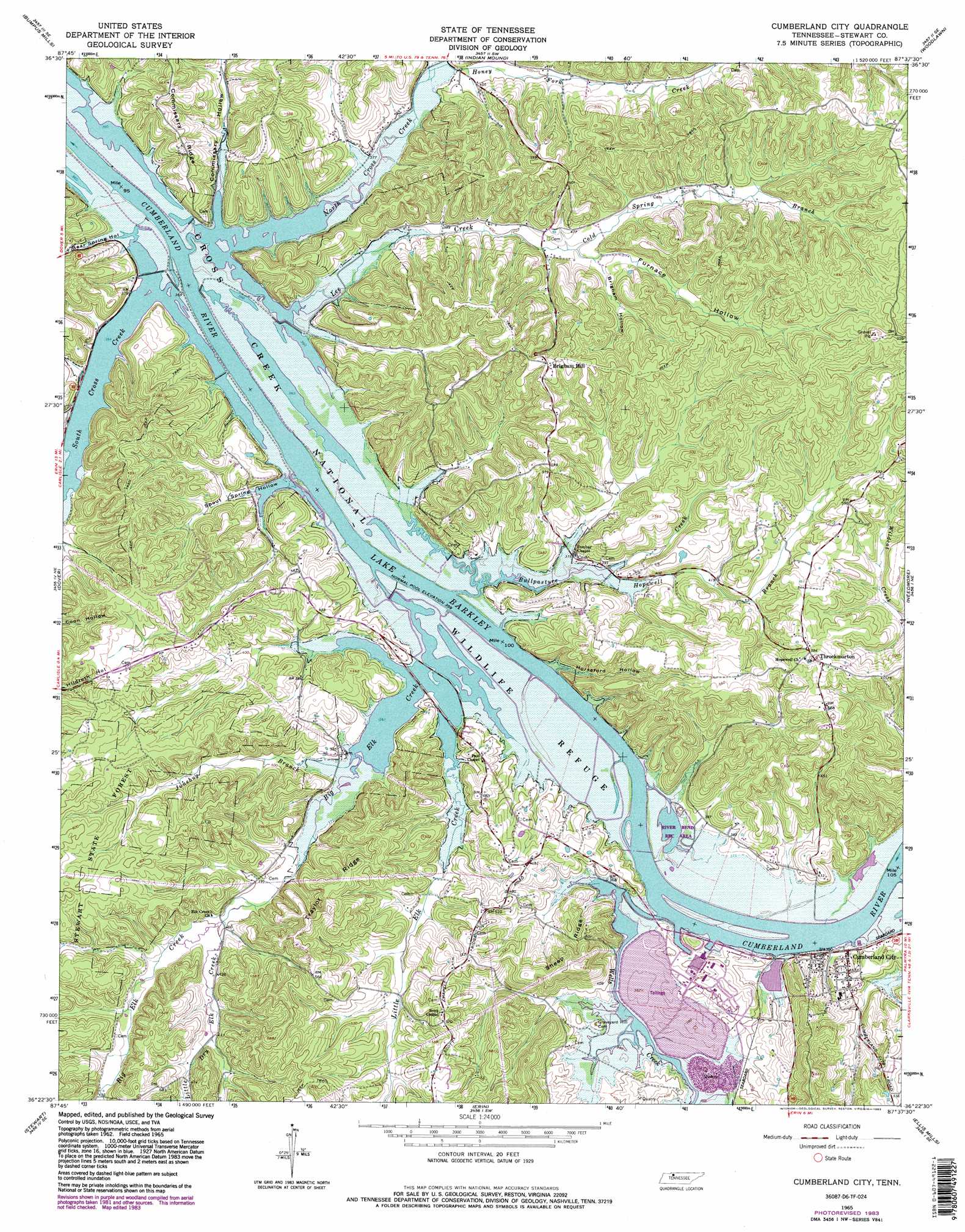
USGS Topo Quad 36087d6 - 1:24,000 scale
| Topo Map Name: | Cumberland City |
| USGS Topo Quad ID: | 36087d6 |
| Print Size: | ca. 21 1/4" wide x 27" high |
| Southeast Coordinates: | 36.375° N latitude / 87.625° W longitude |
| Map Center Coordinates: | 36.4375° N latitude / 87.6875° W longitude |
| U.S. State: | TN |
| Filename: | o36087d6.jpg |
| Download Map JPG Image: | Cumberland City topo map 1:24,000 scale |
| Map Type: | Topographic |
| Topo Series: | 7.5´ |
| Map Scale: | 1:24,000 |
| Source of Map Images: | United States Geological Survey (USGS) |
| Alternate Map Versions: |
Cumberland City TN 1965, updated 1966 Download PDF Buy paper map Cumberland City TN 1965, updated 1983 Download PDF Buy paper map Cumberland City TN 1965, updated 1983 Download PDF Buy paper map Cumberland City TN 2010 Download PDF Buy paper map Cumberland City TN 2013 Download PDF Buy paper map Cumberland City TN 2016 Download PDF Buy paper map |
1:24,000 Topo Quads surrounding Cumberland City
Linton |
Johnson Hollow |
Roaring Spring |
Herndon |
Oak Grove |
Tharpe |
Bumpus Mills |
Indian Mound |
Woodlawn |
New Providence |
Standing Rock |
Dover |
Cumberland City |
Needmore |
Palmyra |
Mckinnon |
Stewart |
Erin |
Ellis Mills |
Slayden |
Harmon Creek |
Halls Creek |
Woolworth |
Ruskin |
Vanleer |
> Back to 36087a1 at 1:100,000 scale
> Back to 36086a1 at 1:250,000 scale
> Back to U.S. Topo Maps home
Cumberland City topo map: Gazetteer
Cumberland City: Basins
Wells Creek Basin elevation 110m 360′Cumberland City: Dams
Cross Creek Dam elevation 111m 364′Pool Five Dam elevation 111m 364′
Pool Fourteen Dam elevation 113m 370′
Pool Six Dam elevation 109m 357′
Cumberland City: Islands
Bald Island (historical) elevation 110m 360′Wells Island (historical) elevation 110m 360′
Cumberland City: Parks
Cross Creeks National Wildlife Refuge elevation 110m 360′River Bend Recreation Area elevation 109m 357′
Cumberland City: Populated Places
Cumberland City elevation 117m 383′Throckmorton elevation 181m 593′
Cumberland City: Reservoirs
Cross Creek Reservoir elevation 111m 364′Pool Five elevation 111m 364′
Pool Fourteen elevation 113m 370′
Pool Six elevation 109m 357′
Cumberland City: Ridges
Commissary Ridge elevation 144m 472′Sheep Ridge elevation 172m 564′
Traylor Ridge elevation 170m 557′
Wright Ridge elevation 168m 551′
Cumberland City: Streams
Big Elk Creek elevation 110m 360′Bullpasture Creek elevation 110m 360′
Cold Spring Branch elevation 128m 419′
Dunbar Branch elevation 107m 351′
East Fork Little Elk Creek elevation 131m 429′
Holliday Branch elevation 109m 357′
Honey Fork Creek elevation 114m 374′
Hopewell Branch elevation 113m 370′
Junebug Branch elevation 113m 370′
Lee Creek elevation 109m 357′
Little Dry Elk Creek elevation 118m 387′
Little Elk Creek elevation 110m 360′
North Cross Creek elevation 109m 357′
Scott Branch elevation 109m 357′
South Cross Creek elevation 111m 364′
Wells Creek elevation 109m 357′
Wilson Branch elevation 109m 357′
Cumberland City: Summits
Brigham Hill elevation 190m 623′Cumberland City: Valleys
Bear Spring Hollow elevation 111m 364′Bone Hollow elevation 122m 400′
Brigham Hollow elevation 134m 439′
Commissary Hollow elevation 109m 357′
Dunaway Hollow elevation 112m 367′
Ellis Hollow elevation 121m 396′
Furnace Hollow elevation 134m 439′
Horseford Hollow elevation 106m 347′
June Bug Hollow elevation 114m 374′
Lee Hollow elevation 109m 357′
Moody Hollow elevation 114m 374′
Moore Hollow elevation 129m 423′
Potatopatch Hollow elevation 116m 380′
Skunk Hollow elevation 117m 383′
Spout Spring Hollow elevation 109m 357′
Travis Hollow elevation 113m 370′
Webb Hollow elevation 115m 377′
Wilson Hollow elevation 111m 364′
Cumberland City digital topo map on disk
Buy this Cumberland City topo map showing relief, roads, GPS coordinates and other geographical features, as a high-resolution digital map file on DVD: