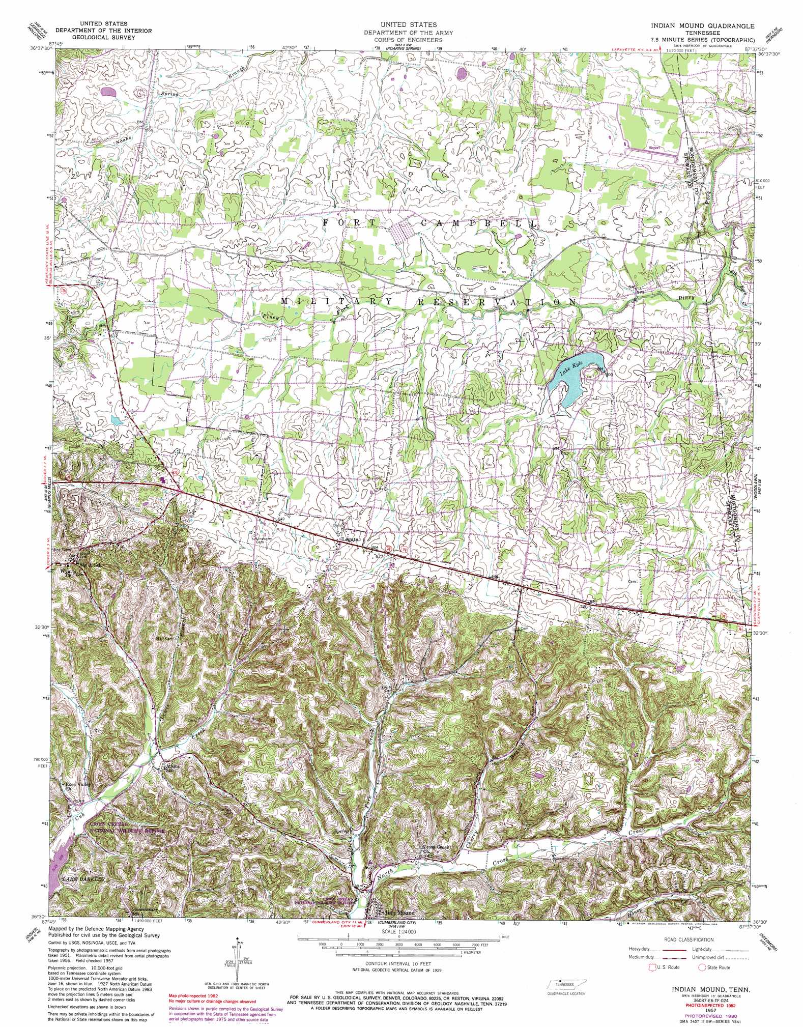
Indian Mound Topo Map Tennessee
To zoom in, hover over the map of Indian Mound
USGS Topo Quad 36087e6 - 1:24,000 scale
| Topo Map Name: | Indian Mound |
| USGS Topo Quad ID: | 36087e6 |
| Print Size: | ca. 21 1/4" wide x 27" high |
| Southeast Coordinates: | 36.5° N latitude / 87.625° W longitude |
| Map Center Coordinates: | 36.5625° N latitude / 87.6875° W longitude |
| U.S. State: | TN |
| Filename: | o36087e6.jpg |
| Download Map JPG Image: | Indian Mound topo map 1:24,000 scale |
| Map Type: | Topographic |
| Topo Series: | 7.5´ |
| Map Scale: | 1:24,000 |
| Source of Map Images: | United States Geological Survey (USGS) |
| Alternate Map Versions: |
Indian Mound TN 1951, updated 1953 Download PDF Buy paper map Indian Mound TN 1957, updated 1960 Download PDF Buy paper map Indian Mound TN 1957, updated 1980 Download PDF Buy paper map Indian Mound TN 1957, updated 1989 Download PDF Buy paper map Indian Mound TN 1957, updated 1989 Download PDF Buy paper map Indian Mound TN 2010 Download PDF Buy paper map Indian Mound TN 2013 Download PDF Buy paper map Indian Mound TN 2016 Download PDF Buy paper map |
1:24,000 Topo Quads surrounding Indian Mound
Canton |
Cadiz |
Caledonia |
Church Hill |
Hopkinsville |
Linton |
Johnson Hollow |
Roaring Spring |
Herndon |
Oak Grove |
Tharpe |
Bumpus Mills |
Indian Mound |
Woodlawn |
New Providence |
Standing Rock |
Dover |
Cumberland City |
Needmore |
Palmyra |
Mckinnon |
Stewart |
Erin |
Ellis Mills |
Slayden |
> Back to 36087e1 at 1:100,000 scale
> Back to 36086a1 at 1:250,000 scale
> Back to U.S. Topo Maps home
Indian Mound topo map: Gazetteer
Indian Mound: Dams
Kyle Lake Dam elevation 180m 590′Pool Four Dam elevation 168m 551′
Indian Mound: Parks
Commissary Hollow Access Point elevation 110m 360′Indian Mound: Populated Places
Ardee (historical) elevation 202m 662′Atkins elevation 120m 393′
Indian Mound elevation 115m 377′
Legate elevation 206m 675′
Parker Town (historical) elevation 189m 620′
Red Top elevation 210m 688′
Wyatts Chapel elevation 212m 695′
Indian Mound: Post Offices
Indian Mound Post Office elevation 118m 387′Indian Mound: Reservoirs
Lake Kyle elevation 180m 590′Pool Four elevation 168m 551′
Indian Mound: Springs
Seay Spring elevation 126m 413′Indian Mound: Streams
Cherry Branch elevation 119m 390′Dicks Fork Creek elevation 114m 374′
Elk Fork Creek elevation 165m 541′
Lewis Branch elevation 119m 390′
Little Cub Creek elevation 118m 387′
North Fork North Cross Creek elevation 147m 482′
Piney Fork Branch elevation 177m 580′
South Fork North Cross Creek elevation 147m 482′
Indian Mound: Valleys
Buckhart Hollow elevation 121m 396′Gillum Hollow elevation 115m 377′
Glover Hollow elevation 167m 547′
Green Hollow elevation 149m 488′
Greer Hollow elevation 135m 442′
Keats Hollow elevation 143m 469′
Lewis Hollow elevation 125m 410′
McNichols Hollow elevation 138m 452′
Rorie Hollow elevation 116m 380′
Shepherd Hollow elevation 121m 396′
Smith Hollow elevation 152m 498′
Terrell Hollow elevation 145m 475′
Weakley Horn Hollow elevation 162m 531′
Wilson Hollow elevation 155m 508′
Indian Mound digital topo map on disk
Buy this Indian Mound topo map showing relief, roads, GPS coordinates and other geographical features, as a high-resolution digital map file on DVD: