Honey Grove Topo Map Kentucky
To zoom in, hover over the map of Honey Grove
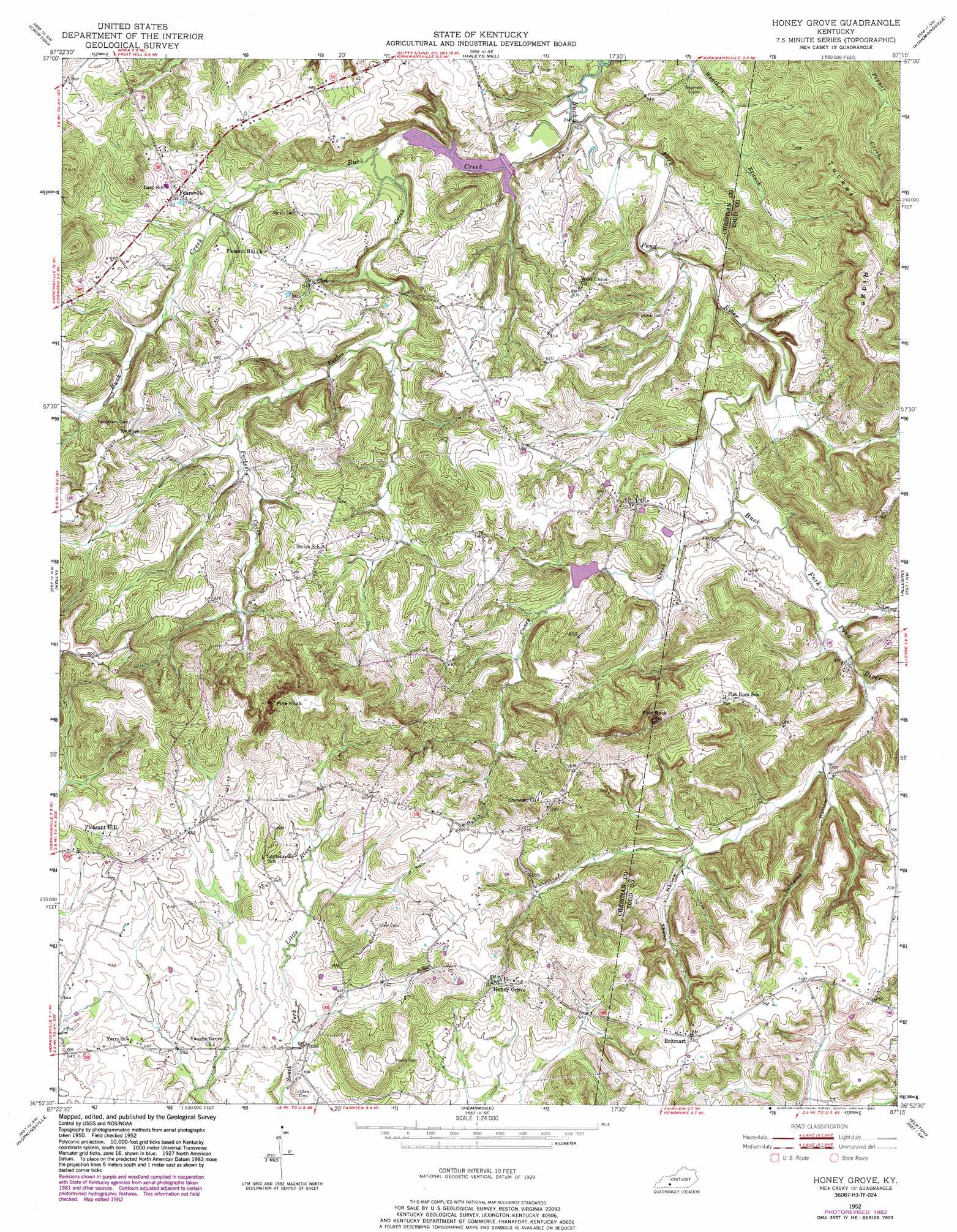
USGS Topo Quad 36087h3 - 1:24,000 scale
| Topo Map Name: | Honey Grove |
| USGS Topo Quad ID: | 36087h3 |
| Print Size: | ca. 21 1/4" wide x 27" high |
| Southeast Coordinates: | 36.875° N latitude / 87.25° W longitude |
| Map Center Coordinates: | 36.9375° N latitude / 87.3125° W longitude |
| U.S. State: | KY |
| Filename: | o36087h3.jpg |
| Download Map JPG Image: | Honey Grove topo map 1:24,000 scale |
| Map Type: | Topographic |
| Topo Series: | 7.5´ |
| Map Scale: | 1:24,000 |
| Source of Map Images: | United States Geological Survey (USGS) |
| Alternate Map Versions: |
Honey Grove KY 1952, updated 1953 Download PDF Buy paper map Honey Grove KY 1952, updated 1976 Download PDF Buy paper map Honey Grove KY 1952, updated 1983 Download PDF Buy paper map Honey Grove KY 2010 Download PDF Buy paper map Honey Grove KY 2013 Download PDF Buy paper map Honey Grove KY 2016 Download PDF Buy paper map |
1:24,000 Topo Quads surrounding Honey Grove
Saint Charles |
Nortonville |
Graham |
Greenville |
Drakesboro |
Dawson Springs Se |
Crofton |
Haleys Mill |
Kirkmansville |
Rosewood |
Pleasant Green Hill |
Kelly |
Honey Grove |
Allegre |
Sharon Grove |
Church Hill |
Hopkinsville |
Pembroke |
Elkton |
Olmstead |
Herndon |
Oak Grove |
Trenton |
Guthrie |
Allensville |
> Back to 36087e1 at 1:100,000 scale
> Back to 36086a1 at 1:250,000 scale
> Back to U.S. Topo Maps home
Honey Grove topo map: Gazetteer
Honey Grove: Populated Places
Britmart elevation 223m 731′Carl elevation 164m 538′
Fearsville elevation 170m 557′
Honey Grove elevation 218m 715′
Ovil elevation 169m 554′
Pleasant Hill elevation 218m 715′
Honey Grove: Ridges
Tucker Ridge elevation 238m 780′Honey Grove: Streams
Buck Creek elevation 137m 449′Caney Creek elevation 143m 469′
Forbes Creek elevation 142m 465′
Honey Grove: Summits
Pilot Rock elevation 293m 961′Pine Knob elevation 262m 859′
Honey Grove: Valleys
Jones Hollow elevation 166m 544′Turnpike Hollow elevation 154m 505′
Honey Grove digital topo map on disk
Buy this Honey Grove topo map showing relief, roads, GPS coordinates and other geographical features, as a high-resolution digital map file on DVD: