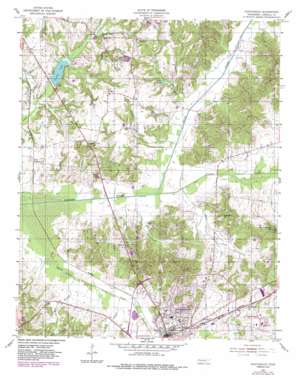
Huntingdon Topo Map Tennessee
To zoom in, hover over the map of Huntingdon
USGS Topo Quad 36088a4 - 1:24,000 scale
| Topo Map Name: | Huntingdon |
| USGS Topo Quad ID: | 36088a4 |
| Print Size: | ca. 21 1/4" wide x 27" high |
| Southeast Coordinates: | 36° N latitude / 88.375° W longitude |
| Map Center Coordinates: | 36.0625° N latitude / 88.4375° W longitude |
| U.S. State: | TN |
| Filename: | o36088a4.jpg |
| Download Map JPG Image: | Huntingdon topo map 1:24,000 scale |
| Map Type: | Topographic |
| Topo Series: | 7.5´ |
| Map Scale: | 1:24,000 |
| Source of Map Images: | United States Geological Survey (USGS) |
| Alternate Map Versions: |
Huntingdon TN 1955, updated 1957 Download PDF Buy paper map Huntingdon TN 1955, updated 1981 Download PDF Buy paper map Huntingdon TN 1955, updated 1984 Download PDF Buy paper map Huntingdon TN 2010 Download PDF Buy paper map Huntingdon TN 2013 Download PDF Buy paper map Huntingdon TN 2016 Download PDF Buy paper map |
1:24,000 Topo Quads surrounding Huntingdon
> Back to 36088a1 at 1:100,000 scale
> Back to 36088a1 at 1:250,000 scale
> Back to U.S. Topo Maps home
Huntingdon topo map: Gazetteer
Huntingdon: Dams
Carroll Lake Dam elevation 117m 383′Huntingdon Sewage Lagoon Dam elevation 112m 367′
Huntingdon: Lakes
Lake Isabel elevation 126m 413′Huntingdon: Parks
Edwards Park elevation 117m 383′Sesquicentennial Park elevation 131m 429′
Huntingdon: Populated Places
Bethel elevation 143m 469′Fairview elevation 143m 469′
Hico elevation 118m 387′
Huntingdon elevation 125m 410′
Long Rock elevation 148m 485′
Huntingdon: Reservoirs
Carroll Lake elevation 117m 383′Huntingdon Sewage Lagoon Lake elevation 112m 367′
Huntingdon: Streams
Bee Branch elevation 110m 360′Brier Creek elevation 112m 367′
Burrow Creek elevation 115m 377′
Guins Creek elevation 111m 364′
Rock Creek elevation 110m 360′
Huntingdon digital topo map on disk
Buy this Huntingdon topo map showing relief, roads, GPS coordinates and other geographical features, as a high-resolution digital map file on DVD:


