Harris Topo Map Tennessee
To zoom in, hover over the map of Harris
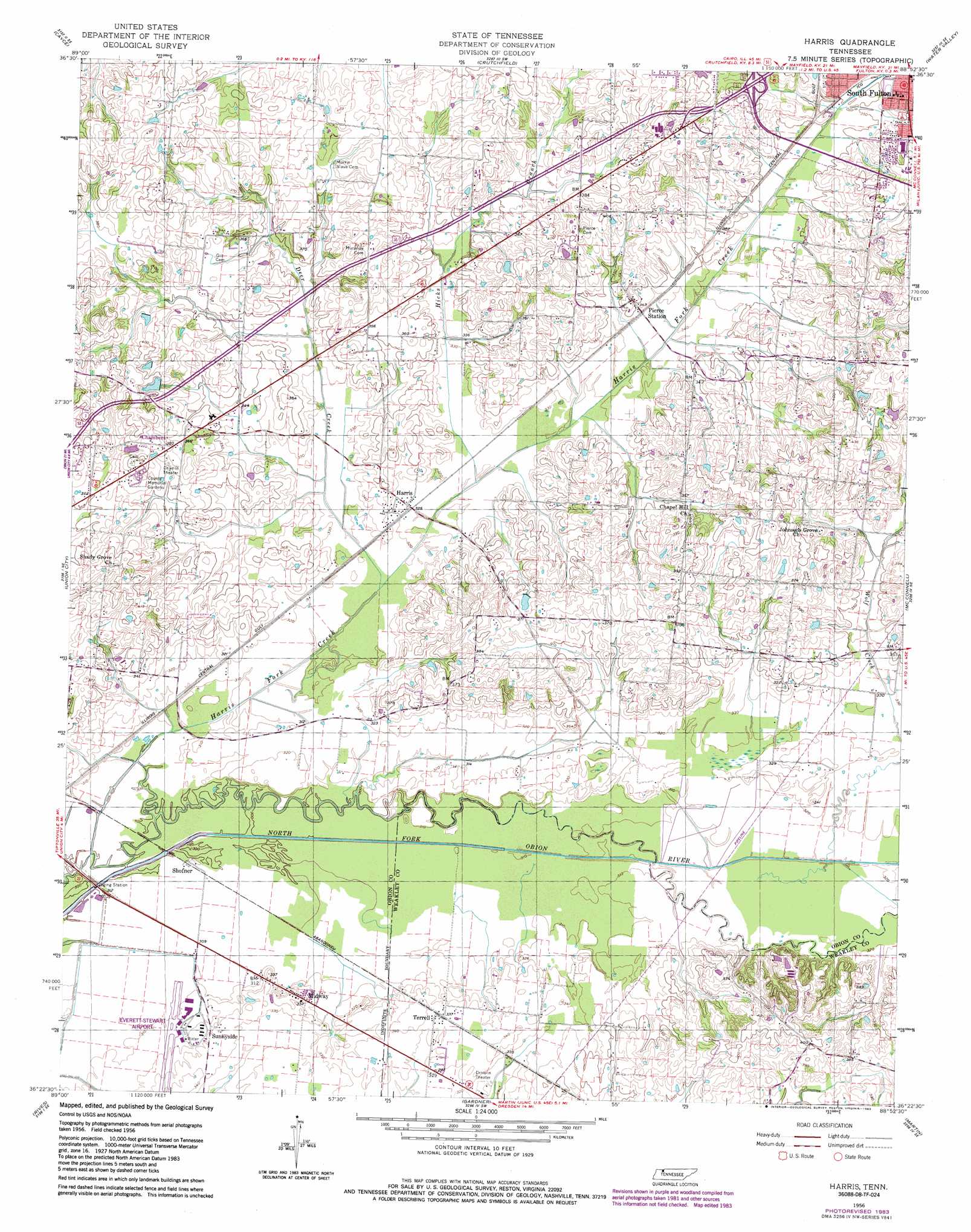
USGS Topo Quad 36088d8 - 1:24,000 scale
| Topo Map Name: | Harris |
| USGS Topo Quad ID: | 36088d8 |
| Print Size: | ca. 21 1/4" wide x 27" high |
| Southeast Coordinates: | 36.375° N latitude / 88.875° W longitude |
| Map Center Coordinates: | 36.4375° N latitude / 88.9375° W longitude |
| U.S. State: | TN |
| Filename: | o36088d8.jpg |
| Download Map JPG Image: | Harris topo map 1:24,000 scale |
| Map Type: | Topographic |
| Topo Series: | 7.5´ |
| Map Scale: | 1:24,000 |
| Source of Map Images: | United States Geological Survey (USGS) |
| Alternate Map Versions: |
Harris TN 1956, updated 1958 Download PDF Buy paper map Harris TN 1956, updated 1981 Download PDF Buy paper map Harris TN 1956, updated 1983 Download PDF Buy paper map Harris TN 2010 Download PDF Buy paper map Harris TN 2013 Download PDF Buy paper map Harris TN 2016 Download PDF Buy paper map |
1:24,000 Topo Quads surrounding Harris
Wolf Island |
Oakton |
Clinton |
Dublin |
Mayfield |
Hickman |
Cayce |
Crutchfield |
Water Valley |
Cuba |
Clayton |
Union City |
Harris |
Mcconnell |
Latham |
Obion |
Rives |
Gardner |
Martin |
Dresden |
Trimble |
Kenton |
Rutherford |
Greenfield |
Pillowville |
> Back to 36088a1 at 1:100,000 scale
> Back to 36088a1 at 1:250,000 scale
> Back to U.S. Topo Maps home
Harris topo map: Gazetteer
Harris: Airports
Everett-Stewart Airport elevation 95m 311′Harris: Dams
White Dam elevation 118m 387′Harris: Populated Places
Chambers elevation 115m 377′Harris elevation 99m 324′
Midway elevation 101m 331′
Pierce Station elevation 104m 341′
Shofner elevation 94m 308′
Sunnyside elevation 101m 331′
Terrell elevation 103m 337′
Harris: Post Offices
Terrell Post Office (historical) elevation 103m 337′Harris: Reservoirs
White Lake elevation 118m 387′Harris: Streams
Deer Creek elevation 95m 311′Hicks Branch elevation 98m 321′
Hicks Branch elevation 98m 321′
Little Cypress Creek elevation 107m 351′
Richland Creek elevation 98m 321′
Harris digital topo map on disk
Buy this Harris topo map showing relief, roads, GPS coordinates and other geographical features, as a high-resolution digital map file on DVD: