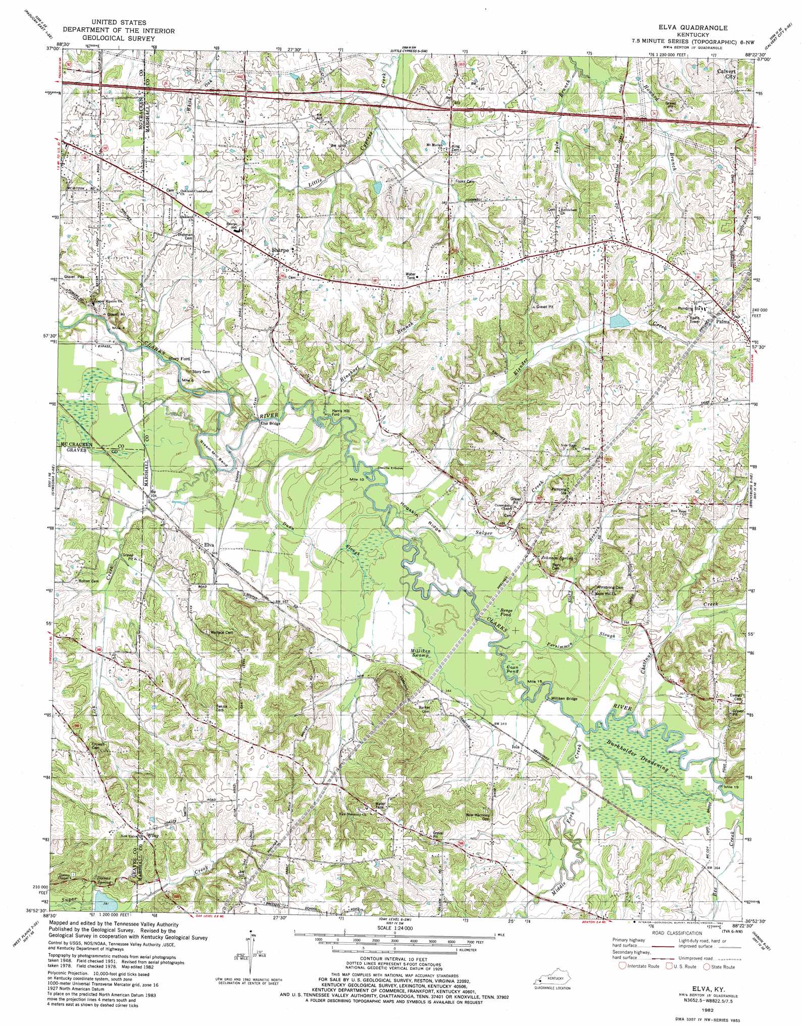
Elva Topo Map Kentucky
To zoom in, hover over the map of Elva
USGS Topo Quad 36088h4 - 1:24,000 scale
| Topo Map Name: | Elva |
| USGS Topo Quad ID: | 36088h4 |
| Print Size: | ca. 21 1/4" wide x 27" high |
| Southeast Coordinates: | 36.875° N latitude / 88.375° W longitude |
| Map Center Coordinates: | 36.9375° N latitude / 88.4375° W longitude |
| U.S. State: | KY |
| Filename: | o36088h4.jpg |
| Download Map JPG Image: | Elva topo map 1:24,000 scale |
| Map Type: | Topographic |
| Topo Series: | 7.5´ |
| Map Scale: | 1:24,000 |
| Source of Map Images: | United States Geological Survey (USGS) |
| Alternate Map Versions: |
Elva KY 1936 Download PDF Buy paper map Elva KY 1951, updated 1956 Download PDF Buy paper map Elva KY 1951, updated 1969 Download PDF Buy paper map Elva KY 1982, updated 1982 Download PDF Buy paper map Elva KY 2010 Download PDF Buy paper map Elva KY 2013 Download PDF Buy paper map Elva KY 2016 Download PDF Buy paper map |
1:24,000 Topo Quads surrounding Elva
Metropolis |
Paducah Ne |
Smithland |
Burna |
Dycusburg |
Paducah West |
Paducah East |
Little Cypress |
Calvert City |
Grand Rivers |
Melber |
Symsonia |
Elva |
Briensburg |
Birmingham Point |
Hickory |
Westplains |
Oak Level |
Hardin |
Fairdealing |
Mayfield |
Farmington |
Kirksey |
Dexter |
Hico |
> Back to 36088e1 at 1:100,000 scale
> Back to 36088a1 at 1:250,000 scale
> Back to U.S. Topo Maps home
Elva topo map: Gazetteer
Elva: Bends
Devils Elbow elevation 102m 334′Steam Mill Bend elevation 101m 331′
Elva: Bridges
Bryan Ford Bridge elevation 97m 318′Elva Bridge elevation 100m 328′
McCoy Ford Bridge elevation 105m 344′
Milliken Bridge elevation 103m 337′
Elva: Populated Places
Elva elevation 105m 344′Harris Hill Ford elevation 98m 321′
Iola elevation 105m 344′
Palma elevation 141m 462′
Sharpe elevation 125m 410′
Elva: Ridges
Hogskin Ridge elevation 104m 341′Elva: Springs
Dooms Spring elevation 121m 396′Johnson Spring elevation 113m 370′
Elva: Streams
Chestnut Creek elevation 103m 337′Dunn Slough Creek elevation 100m 328′
Elender Creek elevation 100m 328′
Howard Branch elevation 107m 351′
Lick Creek elevation 97m 318′
Lyle Branch elevation 107m 351′
Middle Fork Creek elevation 103m 337′
Persimmon Slough Creek elevation 102m 334′
Riley Branch elevation 116m 380′
Rinehart Branch elevation 100m 328′
Salyer Creek elevation 100m 328′
Story Branch elevation 104m 341′
Elva: Swamps
Benge Pond elevation 103m 337′Burkholder Deadening elevation 105m 344′
Coon Pond elevation 103m 337′
Milliken Swamp elevation 103m 337′
Elva digital topo map on disk
Buy this Elva topo map showing relief, roads, GPS coordinates and other geographical features, as a high-resolution digital map file on DVD: