Dyersburg Topo Map Tennessee
To zoom in, hover over the map of Dyersburg
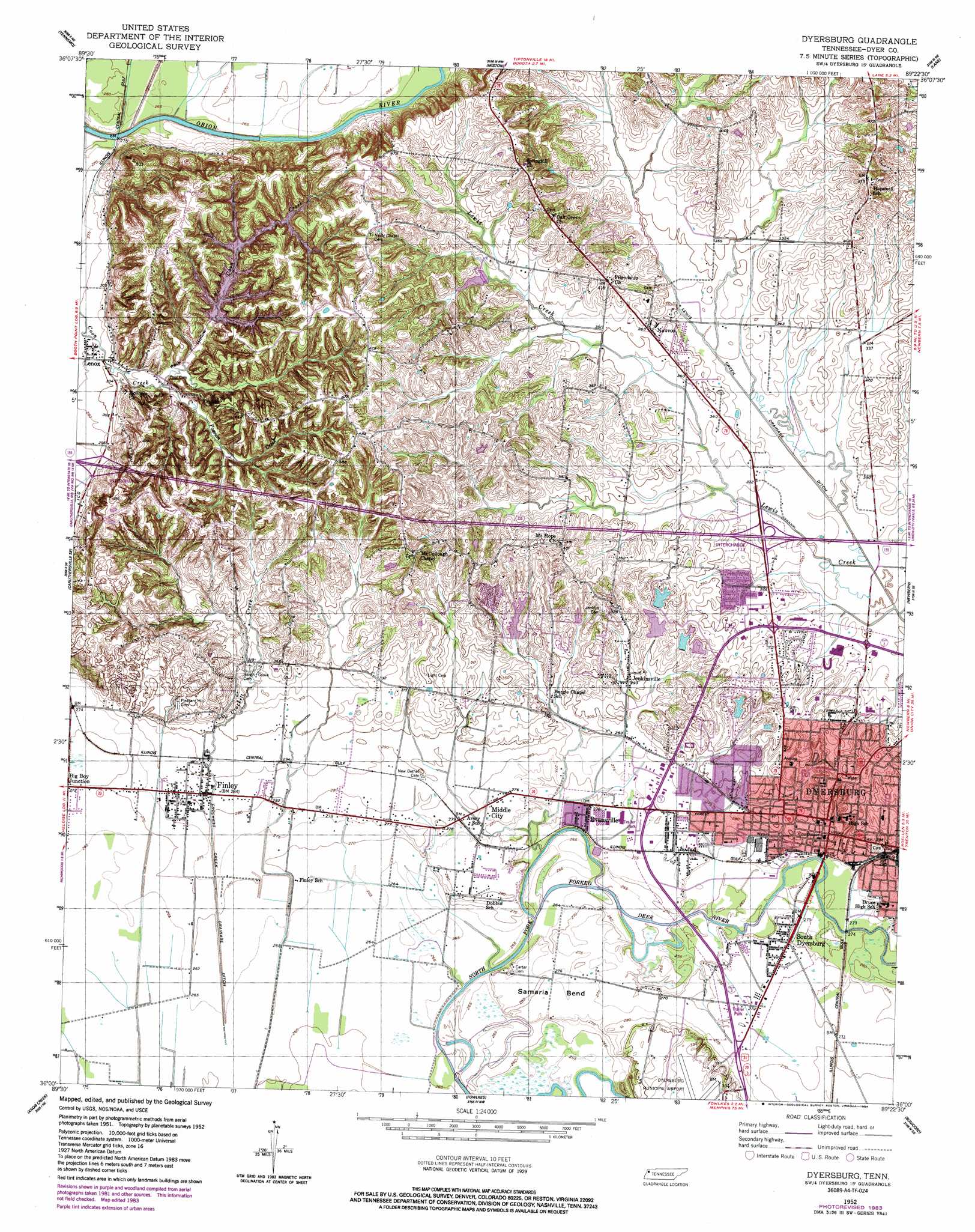
USGS Topo Quad 36089a4 - 1:24,000 scale
| Topo Map Name: | Dyersburg |
| USGS Topo Quad ID: | 36089a4 |
| Print Size: | ca. 21 1/4" wide x 27" high |
| Southeast Coordinates: | 36° N latitude / 89.375° W longitude |
| Map Center Coordinates: | 36.0625° N latitude / 89.4375° W longitude |
| U.S. State: | TN |
| Filename: | o36089a4.jpg |
| Download Map JPG Image: | Dyersburg topo map 1:24,000 scale |
| Map Type: | Topographic |
| Topo Series: | 7.5´ |
| Map Scale: | 1:24,000 |
| Source of Map Images: | United States Geological Survey (USGS) |
| Alternate Map Versions: |
Dyersburg TN 1952, updated 1953 Download PDF Buy paper map Dyersburg TN 1952, updated 1984 Download PDF Buy paper map Dyersburg TN 2010 Download PDF Buy paper map Dyersburg TN 2013 Download PDF Buy paper map Dyersburg TN 2016 Download PDF Buy paper map |
1:24,000 Topo Quads surrounding Dyersburg
Stanley |
Mooring |
Ridgely |
Hornbeak |
Obion |
Caruthersville |
Tennemo |
Miston |
Lane |
Trimble |
Cottonwood Point |
Caruthersville Se |
Dyersburg |
Newbern |
Tatumville |
Chic |
Knob Creek |
Fowlkes |
Bonicord |
Friendship |
Open Lake |
Ripley North |
Gates |
Chestnut Bluff |
Maury City |
> Back to 36089a1 at 1:100,000 scale
> Back to 36088a1 at 1:250,000 scale
> Back to U.S. Topo Maps home
Dyersburg topo map: Gazetteer
Dyersburg: Airports
Dyersburg Municipal Airport elevation 100m 328′Dyersburg: Bends
Samaria Bend elevation 83m 272′Dyersburg: Canals
Crockett Creek Drainage Ditch elevation 83m 272′Lewis Creek Drainage Ditch elevation 93m 305′
Dyersburg: Crossings
Interchange 13 elevation 96m 314′Interchange 7 elevation 88m 288′
Dyersburg: Dams
Lewis Creek Tributary Lake Site 60-11 Dam elevation 110m 360′OFDBA Dam Number 60-13 elevation 126m 413′
OFDBA Dam Number 60-6 elevation 101m 331′
Pioneer Lake Dam Number Five elevation 99m 324′
Pioneer Lake Dam Number Four elevation 91m 298′
Pioneer Lake Dam Number One elevation 103m 337′
Pioneer Lake Dam Number Three elevation 100m 328′
Pioneer Lake Dam Number Two elevation 99m 324′
Dyersburg: Parks
Okeena Park elevation 110m 360′Okeena Park elevation 111m 364′
Dyersburg: Populated Places
Band Mill elevation 83m 272′Big Boy Junction elevation 82m 269′
Dyersburg elevation 94m 308′
Evansville elevation 83m 272′
Finley elevation 86m 282′
Friendship elevation 124m 406′
Jenkinsville elevation 92m 301′
Lenox elevation 88m 288′
Middle City elevation 83m 272′
Mount Hope elevation 117m 383′
Nauvoo elevation 107m 351′
South Dyersburg elevation 82m 269′
Dyersburg: Post Offices
Dyersburg Post Office elevation 91m 298′Finley Post Office elevation 86m 282′
Lenox Post Office elevation 88m 288′
Dyersburg: Reservoirs
Lewis Creek Tributary Lake 60-11 elevation 110m 360′OFDBA Lake Site Number 60-13 elevation 126m 413′
OFDBA Lake Site Number 60-6 elevation 101m 331′
Pioneer Lake Number Five elevation 99m 324′
Pioneer Lake Number Four elevation 91m 298′
Pioneer Lake Number One elevation 103m 337′
Pioneer Lake Number Three elevation 100m 328′
Pioneer Lake Number Two elevation 99m 324′
Dyersburg: Streams
Crockett Creek elevation 81m 265′Possum Creek elevation 93m 305′
Dyersburg: Valleys
Peck Hollow elevation 90m 295′Dyersburg digital topo map on disk
Buy this Dyersburg topo map showing relief, roads, GPS coordinates and other geographical features, as a high-resolution digital map file on DVD: