Pocahontas Topo Map Arkansas
To zoom in, hover over the map of Pocahontas
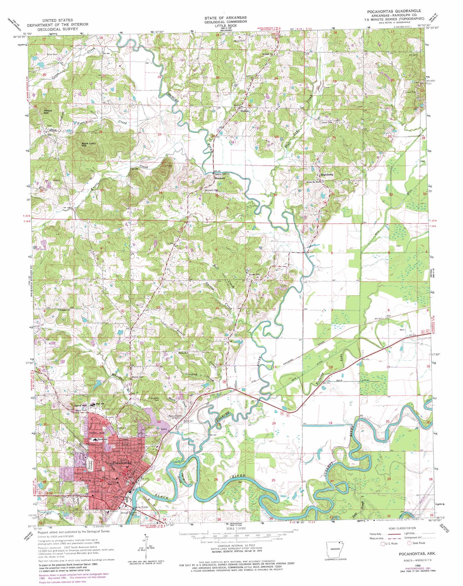
USGS Topo Quad 36090c8 - 1:24,000 scale
| Topo Map Name: | Pocahontas |
| USGS Topo Quad ID: | 36090c8 |
| Print Size: | ca. 21 1/4" wide x 27" high |
| Southeast Coordinates: | 36.25° N latitude / 90.875° W longitude |
| Map Center Coordinates: | 36.3125° N latitude / 90.9375° W longitude |
| U.S. State: | AR |
| Filename: | o36090c8.jpg |
| Download Map JPG Image: | Pocahontas topo map 1:24,000 scale |
| Map Type: | Topographic |
| Topo Series: | 7.5´ |
| Map Scale: | 1:24,000 |
| Source of Map Images: | United States Geological Survey (USGS) |
| Alternate Map Versions: |
Pocahontas AR 1966, updated 1967 Download PDF Buy paper map Pocahontas AR 1966, updated 1982 Download PDF Buy paper map Pocahontas AR 2011 Download PDF Buy paper map Pocahontas AR 2014 Download PDF Buy paper map |
1:24,000 Topo Quads surrounding Pocahontas
Billmore |
Gatewood |
Poynor |
Doniphan South |
Oxly |
Dalton |
Warm Springs |
Maynard |
Supply |
Datto |
Ravenden Springs |
Ravenden Springs Se |
Pocahontas |
Reyno |
Peach Orchard |
Imboden |
Noland |
Manson |
O'Kean |
Delaplaine |
Eaton |
Black Rock |
Walnut Ridge |
Walnut Ridge Se |
Walcott |
> Back to 36090a1 at 1:100,000 scale
> Back to 36090a1 at 1:250,000 scale
> Back to U.S. Topo Maps home
Pocahontas topo map: Gazetteer
Pocahontas: Airports
Randolph County Medical Center Heliport elevation 132m 433′Pocahontas: Bays
Twin Eddies elevation 76m 249′Pocahontas: Canals
Beaver Ditch (historical) elevation 79m 259′Frisco Ditch elevation 79m 259′
Lateral Number 7 elevation 80m 262′
Mule Ditch elevation 79m 259′
Pocahontas: Channels
Reeves Reach elevation 76m 249′Pocahontas: Crossings
Old Skaggs Ferry (historical) elevation 71m 232′Pocahontas: Dams
Baltz Lake Dam elevation 81m 265′Bates Lake Dam elevation 95m 311′
Pocahontas: Guts
Old River Slough elevation 76m 249′Throgmortan Slough (historical) elevation 79m 259′
Pocahontas: Parks
Alexander Park elevation 100m 328′Pocahontas: Populated Places
Attica elevation 112m 367′Brockett elevation 83m 272′
Cedar Grove elevation 99m 324′
Debrow (historical) elevation 106m 347′
East Pocahontas elevation 80m 262′
Engelberg elevation 106m 347′
Pocahontas elevation 90m 295′
Poluca (historical) elevation 82m 269′
Running Lake (historical) elevation 78m 255′
Stokes elevation 99m 324′
Pocahontas: Post Offices
Pocahontas Post Office elevation 95m 311′Pocahontas: Reservoirs
Baltz Lake elevation 81m 265′Bates Lake elevation 95m 311′
Pocahontas: Streams
Bell Creek elevation 83m 272′Crooked Creek elevation 78m 255′
Current River elevation 76m 249′
Deep Slough elevation 76m 249′
Flat Lake Creek elevation 80m 262′
Foster Creek elevation 84m 275′
Fourche River elevation 75m 246′
Fourche River elevation 77m 252′
Gaines Creek elevation 79m 259′
Gross Creek elevation 87m 285′
Hamil Creek elevation 77m 252′
Knotts Creek elevation 82m 269′
Mansker Creek elevation 76m 249′
Marr Creek elevation 74m 242′
Pettit Creek elevation 75m 246′
Running Lake elevation 78m 255′
Pocahontas: Summits
Attica Hill elevation 148m 485′Aunt Lucy Hill elevation 145m 475′
Sand Hill elevation 139m 456′
Pocahontas digital topo map on disk
Buy this Pocahontas topo map showing relief, roads, GPS coordinates and other geographical features, as a high-resolution digital map file on DVD: