Oxly Topo Map Missouri
To zoom in, hover over the map of Oxly
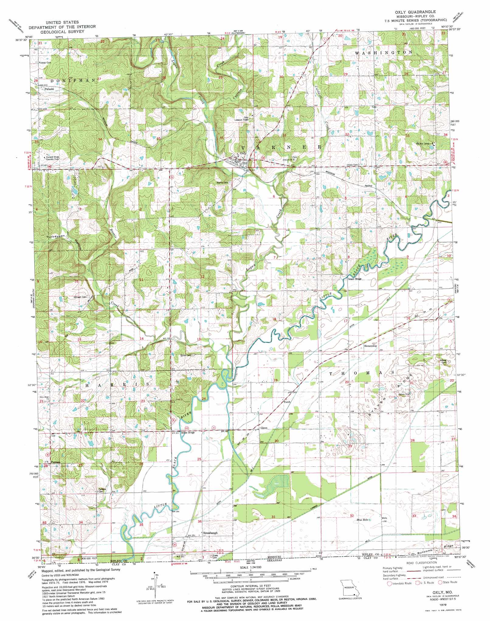
USGS Topo Quad 36090e6 - 1:24,000 scale
| Topo Map Name: | Oxly |
| USGS Topo Quad ID: | 36090e6 |
| Print Size: | ca. 21 1/4" wide x 27" high |
| Southeast Coordinates: | 36.5° N latitude / 90.625° W longitude |
| Map Center Coordinates: | 36.5625° N latitude / 90.6875° W longitude |
| U.S. State: | MO |
| Filename: | o36090e6.jpg |
| Download Map JPG Image: | Oxly topo map 1:24,000 scale |
| Map Type: | Topographic |
| Topo Series: | 7.5´ |
| Map Scale: | 1:24,000 |
| Source of Map Images: | United States Geological Survey (USGS) |
| Alternate Map Versions: |
Oxly MO 1979, updated 1980 Download PDF Buy paper map Oxly MO 2011 Download PDF Buy paper map Oxly MO 2015 Download PDF Buy paper map |
1:24,000 Topo Quads surrounding Oxly
Grandin Sw |
Grandin |
Hogan Hollow |
Stringtown |
Poplar Bluff |
Briar |
Doniphan North |
Flatwoods |
Fairdealing |
Harviell |
Poynor |
Doniphan South |
Oxly |
Naylor |
Vastus |
Maynard |
Supply |
Datto |
Corning |
Mcdougal |
Pocahontas |
Reyno |
Peach Orchard |
Knobel |
Boydsville |
> Back to 36090e1 at 1:100,000 scale
> Back to 36090a1 at 1:250,000 scale
> Back to U.S. Topo Maps home
Oxly topo map: Gazetteer
Oxly: Areas
Southeastern Ridge and Basin elevation 90m 295′Oxly: Bridges
Bethel Bridge elevation 89m 291′Sewell Bridge elevation 90m 295′
Oxly: Canals
Cypress Ditch elevation 87m 285′Ditch Number 2 elevation 90m 295′
Oxly: Dams
Smith Lake Dam elevation 121m 396′Oxly: Lakes
Blue Hole elevation 88m 288′Oxly: Populated Places
Glenn elevation 89m 291′Hemenway elevation 90m 295′
Martinsburg (historical) elevation 103m 337′
Oxly elevation 104m 341′
Pulaski elevation 132m 433′
Purman elevation 114m 374′
Riga (historical) elevation 90m 295′
Sinsabaugh elevation 89m 291′
Torch elevation 90m 295′
Oxly: Post Offices
Acorn Post Office elevation 89m 291′Oxly: Reservoirs
Smith Dam elevation 121m 396′Oxly: Ridges
Sylvan Ridge elevation 92m 301′Oxly: Streams
Caldwell Creek elevation 93m 305′Cypress Creek elevation 98m 321′
Deer Lick Creek elevation 89m 291′
Harris Creek elevation 88m 288′
Logan Creek elevation 88m 288′
Oxly: Valleys
Turkeypen Hollow elevation 98m 321′Oxly digital topo map on disk
Buy this Oxly topo map showing relief, roads, GPS coordinates and other geographical features, as a high-resolution digital map file on DVD: