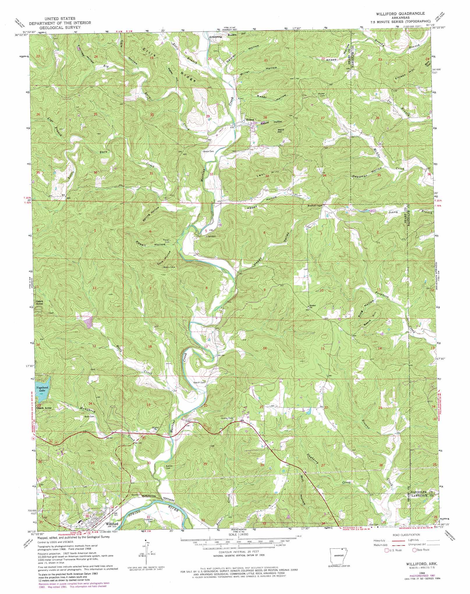
Williford Topo Map Arkansas
To zoom in, hover over the map of Williford
USGS Topo Quad 36091c3 - 1:24,000 scale
| Topo Map Name: | Williford |
| USGS Topo Quad ID: | 36091c3 |
| Print Size: | ca. 21 1/4" wide x 27" high |
| Southeast Coordinates: | 36.25° N latitude / 91.25° W longitude |
| Map Center Coordinates: | 36.3125° N latitude / 91.3125° W longitude |
| U.S. State: | AR |
| Filename: | o36091c3.jpg |
| Download Map JPG Image: | Williford topo map 1:24,000 scale |
| Map Type: | Topographic |
| Topo Series: | 7.5´ |
| Map Scale: | 1:24,000 |
| Source of Map Images: | United States Geological Survey (USGS) |
| Alternate Map Versions: |
Williford AR 1968, updated 1969 Download PDF Buy paper map Williford AR 1968, updated 1982 Download PDF Buy paper map Williford AR 2011 Download PDF Buy paper map Williford AR 2014 Download PDF Buy paper map |
1:24,000 Topo Quads surrounding Williford
Thayer |
Conch |
Myrtle |
Billmore |
Gatewood |
Mammoth Spring |
Wirth |
Hardy Ne |
Dalton |
Warm Springs |
Stuart |
Hardy |
Williford |
Ravenden Springs |
Ravenden Springs Se |
Ash Flat |
Sitka |
Ravenden |
Imboden |
Noland |
Evening Shade |
Poughkeepsie |
Smithville |
Eaton |
Black Rock |
> Back to 36091a1 at 1:100,000 scale
> Back to 36090a1 at 1:250,000 scale
> Back to U.S. Topo Maps home
Williford topo map: Gazetteer
Williford: Dams
Vagabond Lake Dam elevation 143m 469′Williford: Populated Places
Armstrong elevation 158m 518′Williford elevation 100m 328′
Williford: Reservoirs
Vagabond Lake elevation 143m 469′Williford: Ridges
Ellis Ridge elevation 187m 613′Williford: Streams
Big Barn Creek elevation 130m 426′Booth Creek elevation 104m 341′
Dayberry Creek elevation 97m 318′
Ellis Branch elevation 137m 449′
Humphrey Creek elevation 95m 311′
Lige Branch elevation 163m 534′
Little Barn Creek elevation 119m 390′
Martins Creek elevation 92m 301′
Section Branch elevation 149m 488′
Williford: Summits
Beard Hill elevation 197m 646′Ellison Hill elevation 216m 708′
Levi Hill elevation 216m 708′
Ward Hill elevation 219m 718′
Williford: Valleys
Bowers Hollow elevation 142m 465′Brown Hollow elevation 161m 528′
Cartwright Hollow elevation 188m 616′
Cave Hollow elevation 123m 403′
Cole Hollow elevation 161m 528′
Deadman Hollow elevation 129m 423′
Eldridge Hollow elevation 170m 557′
Geisler Hollow elevation 136m 446′
Happy Hollow elevation 122m 400′
Happy Valley elevation 111m 364′
King Hollow elevation 133m 436′
Knapp Hollow elevation 152m 498′
Miller Hollow elevation 135m 442′
Powell Hollow elevation 117m 383′
Prewitt Hollow elevation 130m 426′
Rader Hollow elevation 132m 433′
Spring Hollow elevation 128m 419′
Walley Hollow elevation 153m 501′
Williford digital topo map on disk
Buy this Williford topo map showing relief, roads, GPS coordinates and other geographical features, as a high-resolution digital map file on DVD: