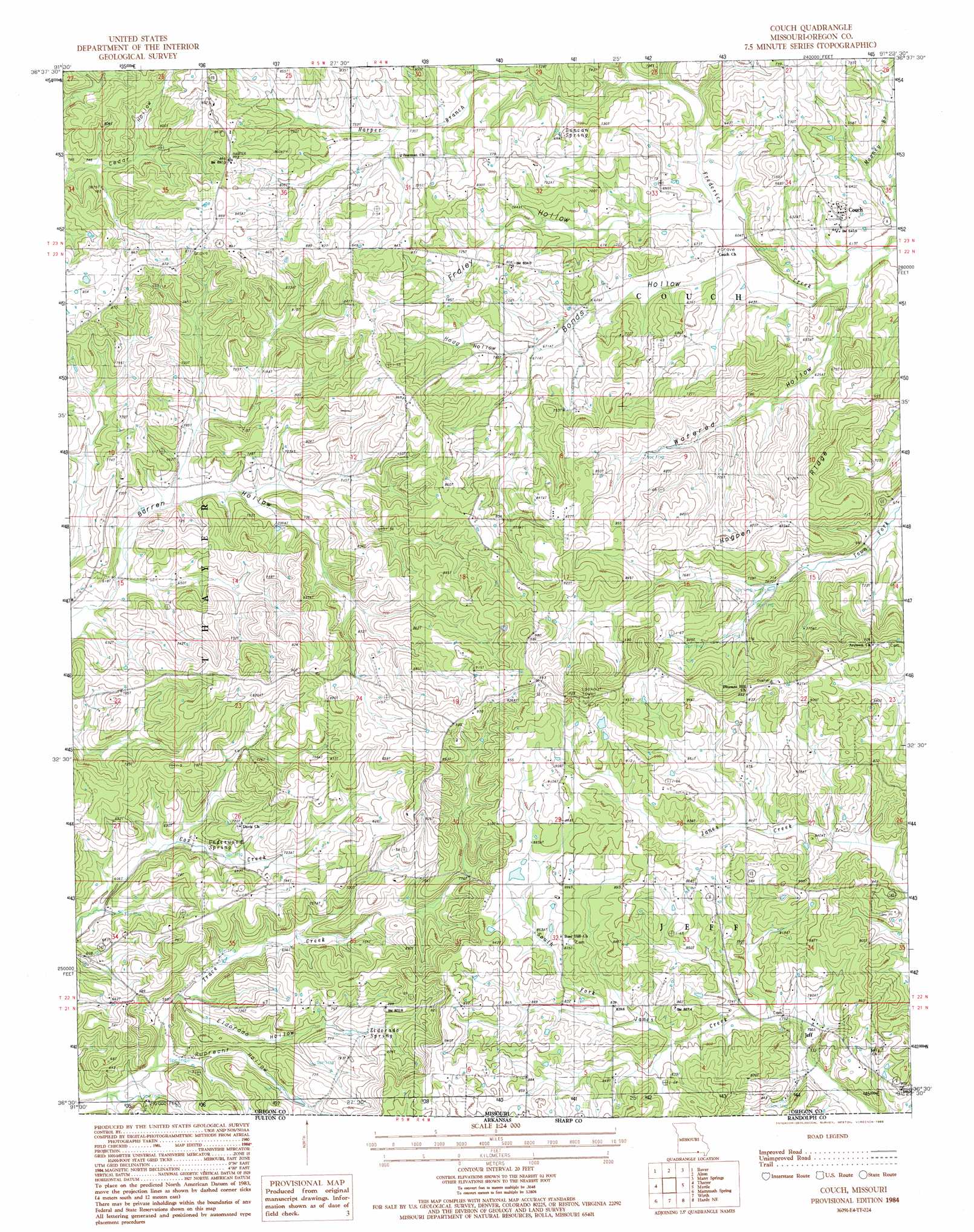
Conch Topo Map Missouri
To zoom in, hover over the map of Conch
USGS Topo Quad 36091e4 - 1:24,000 scale
| Topo Map Name: | Conch |
| USGS Topo Quad ID: | 36091e4 |
| Print Size: | ca. 21 1/4" wide x 27" high |
| Southeast Coordinates: | 36.5° N latitude / 91.375° W longitude |
| Map Center Coordinates: | 36.5625° N latitude / 91.4375° W longitude |
| U.S. State: | MO |
| Filename: | o36091e4.jpg |
| Download Map JPG Image: | Conch topo map 1:24,000 scale |
| Map Type: | Topographic |
| Topo Series: | 7.5´ |
| Map Scale: | 1:24,000 |
| Source of Map Images: | United States Geological Survey (USGS) |
| Alternate Map Versions: |
Couch MO 1982, updated 1983 Download PDF Buy paper map Couch MO 1984, updated 1985 Download PDF Buy paper map Couch MO 2011 Download PDF Buy paper map Couch MO 2015 Download PDF Buy paper map |
1:24,000 Topo Quads surrounding Conch
Peace Valley |
Thomasville |
Peidmont Hollow |
Greer |
Wilderness |
Brandsville |
Rover |
Alton |
Many Springs |
Riverton |
Koshkonong |
Thayer |
Conch |
Myrtle |
Billmore |
Camp |
Mammoth Spring |
Wirth |
Hardy Ne |
Dalton |
Agnos |
Stuart |
Hardy |
Williford |
Ravenden Springs |
> Back to 36091e1 at 1:100,000 scale
> Back to 36090a1 at 1:250,000 scale
> Back to U.S. Topo Maps home
Conch topo map: Gazetteer
Conch: Dams
Wendt Lake Dam elevation 278m 912′Conch: Populated Places
Corona elevation 283m 928′Couch elevation 207m 679′
Jeff elevation 233m 764′
Midway elevation 270m 885′
Conch: Post Offices
Hy Post Office elevation 217m 711′Conch: Ridges
Hogpen Ridge elevation 247m 810′Conch: Springs
Duncan Spring elevation 217m 711′Eldorado Spring elevation 223m 731′
Hart Spring elevation 189m 620′
Ruprecht Spring elevation 180m 590′
Underwood Spring elevation 203m 666′
Conch: Streams
Harper Branch elevation 199m 652′Mooney Branch elevation 177m 580′
Conch: Valleys
Bonds Hollow elevation 184m 603′Dead Dutchman Hollow elevation 177m 580′
Eldorado Hollow elevation 183m 600′
Fraley Hollow elevation 186m 610′
Hoag Hollow elevation 211m 692′
Ruprecht Hollow elevation 176m 577′
Watered Hollow elevation 178m 583′
Conch digital topo map on disk
Buy this Conch topo map showing relief, roads, GPS coordinates and other geographical features, as a high-resolution digital map file on DVD: