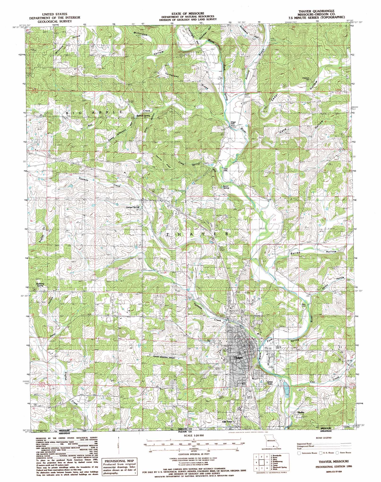
Thayer Topo Map Missouri
To zoom in, hover over the map of Thayer
USGS Topo Quad 36091e5 - 1:24,000 scale
| Topo Map Name: | Thayer |
| USGS Topo Quad ID: | 36091e5 |
| Print Size: | ca. 21 1/4" wide x 27" high |
| Southeast Coordinates: | 36.5° N latitude / 91.5° W longitude |
| Map Center Coordinates: | 36.5625° N latitude / 91.5625° W longitude |
| U.S. State: | MO |
| Filename: | o36091e5.jpg |
| Download Map JPG Image: | Thayer topo map 1:24,000 scale |
| Map Type: | Topographic |
| Topo Series: | 7.5´ |
| Map Scale: | 1:24,000 |
| Source of Map Images: | United States Geological Survey (USGS) |
| Alternate Map Versions: |
Thayer SE MO 1976, updated 1977 Download PDF Buy paper map Thayer MO 1986, updated 1986 Download PDF Buy paper map Thayer MO 2011 Download PDF Buy paper map Thayer MO 2015 Download PDF Buy paper map |
1:24,000 Topo Quads surrounding Thayer
White Church |
Peace Valley |
Thomasville |
Peidmont Hollow |
Greer |
West Plains |
Brandsville |
Rover |
Alton |
Many Springs |
Lanton |
Koshkonong |
Thayer |
Conch |
Myrtle |
Salem Knob |
Camp |
Mammoth Spring |
Wirth |
Hardy Ne |
Salem |
Agnos |
Stuart |
Hardy |
Williford |
> Back to 36091e1 at 1:100,000 scale
> Back to 36090a1 at 1:250,000 scale
> Back to U.S. Topo Maps home
Thayer topo map: Gazetteer
Thayer: Airports
Thayer Memorial Airport elevation 214m 702′Thayer: Populated Places
Allen Ford elevation 160m 524′Clifton elevation 195m 639′
Green Town elevation 185m 606′
Old Town elevation 192m 629′
Shelby elevation 173m 567′
Sloan Ford elevation 174m 570′
Thayer elevation 161m 528′
Thayer: Ridges
Deerlick Ridge elevation 250m 820′Turkeypen Ridge elevation 257m 843′
Thayer: Springs
Batman Spring elevation 208m 682′Childers Spring elevation 252m 826′
Heimer Spring elevation 221m 725′
Hellberg Spring elevation 233m 764′
Spout Spring elevation 185m 606′
Thayer: Streams
Anthony Branch elevation 178m 583′Bay Creek elevation 177m 580′
Cox Creek elevation 156m 511′
Mill Stone Branch elevation 188m 616′
Twomile Creek elevation 159m 521′
Thayer: Valleys
Barren Hollow elevation 164m 538′Camp Jefferson Hollow elevation 208m 682′
Cave Hollow elevation 177m 580′
Cedar Hollow elevation 184m 603′
Crazy Spring Hollow elevation 178m 583′
Goodwin Hollow elevation 196m 643′
Gunther Hollow elevation 187m 613′
Helms Hollow elevation 163m 534′
Hurst Hollow elevation 199m 652′
Millstone Hollow elevation 189m 620′
Slater Hollow elevation 204m 669′
Trantham Hollow elevation 190m 623′
Thayer digital topo map on disk
Buy this Thayer topo map showing relief, roads, GPS coordinates and other geographical features, as a high-resolution digital map file on DVD: