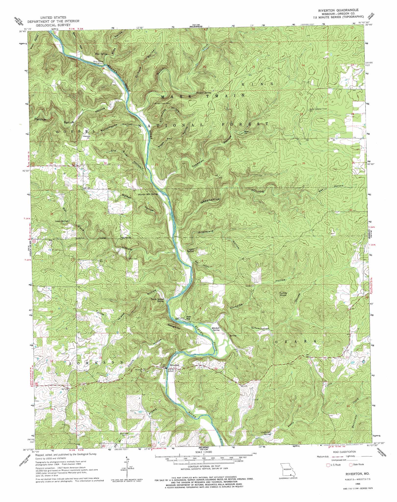
Riverton Topo Map Missouri
To zoom in, hover over the map of Riverton
USGS Topo Quad 36091f2 - 1:24,000 scale
| Topo Map Name: | Riverton |
| USGS Topo Quad ID: | 36091f2 |
| Print Size: | ca. 21 1/4" wide x 27" high |
| Southeast Coordinates: | 36.625° N latitude / 91.125° W longitude |
| Map Center Coordinates: | 36.6875° N latitude / 91.1875° W longitude |
| U.S. State: | MO |
| Filename: | o36091f2.jpg |
| Download Map JPG Image: | Riverton topo map 1:24,000 scale |
| Map Type: | Topographic |
| Topo Series: | 7.5´ |
| Map Scale: | 1:24,000 |
| Source of Map Images: | United States Geological Survey (USGS) |
| Alternate Map Versions: |
Riverton MO 1965, updated 1967 Download PDF Buy paper map Riverton MO 1965, updated 1977 Download PDF Buy paper map Riverton MO 1997, updated 2000 Download PDF Buy paper map Riverton MO 2011 Download PDF Buy paper map Riverton MO 2015 Download PDF Buy paper map |
| FStopo: | US Forest Service topo Riverton is available: Download FStopo PDF Download FStopo TIF |
1:24,000 Topo Quads surrounding Riverton
Birch Tree |
Low Wassie |
Fremont |
Van Buren South |
Big Spring |
Peidmont Hollow |
Greer |
Wilderness |
Handy |
Grandin Sw |
Alton |
Many Springs |
Riverton |
Bardley |
Briar |
Conch |
Myrtle |
Billmore |
Gatewood |
Poynor |
Wirth |
Hardy Ne |
Dalton |
Warm Springs |
Maynard |
> Back to 36091e1 at 1:100,000 scale
> Back to 36090a1 at 1:250,000 scale
> Back to U.S. Topo Maps home
Riverton topo map: Gazetteer
Riverton: Populated Places
Boze Mill elevation 139m 456′Riverton elevation 128m 419′
Riverton: Post Offices
Coin Post Office elevation 210m 688′Riverton: Springs
Anderson Spring elevation 135m 442′Bliss Spring elevation 146m 479′
Boze Mill Spring elevation 129m 423′
Conner Spring elevation 135m 442′
Fiddler Spring elevation 163m 534′
Jones Spring elevation 192m 629′
Mitchell Spring elevation 133m 436′
Powder Mill Spring elevation 139m 456′
Turtle Island Spring elevation 132m 433′
Riverton: Streams
Dry Branch elevation 154m 505′Hollow Branch elevation 122m 400′
Whites Creek elevation 134m 439′
Riverton: Summits
Conner Hill elevation 239m 784′Tater Hill elevation 182m 597′
Turkey Knob elevation 234m 767′
Riverton: Valleys
Barn Hollow elevation 143m 469′Bat Cave Hollow elevation 134m 439′
Bay Hollow elevation 132m 433′
Bliss Hollow elevation 140m 459′
Boze Mill Hollow elevation 194m 636′
Couch Hollow elevation 128m 419′
Freeman Hollow elevation 139m 456′
Graveyard Hollow elevation 137m 449′
Greenbriar Hollow elevation 134m 439′
Hay Hollow elevation 209m 685′
Klondike Hollow elevation 135m 442′
Midnight Hollow elevation 134m 439′
Old River Hollow elevation 137m 449′
Orchard Hollow elevation 139m 456′
Panther Spring Hollow elevation 135m 442′
Schoolhouse Hollow elevation 137m 449′
Schoolhouse Hollow elevation 144m 472′
Slash Bay Hollow elevation 138m 452′
Stillhouse Hollow elevation 137m 449′
Turtle Island Hollow elevation 130m 426′
Walker Hollow elevation 138m 452′
Riverton digital topo map on disk
Buy this Riverton topo map showing relief, roads, GPS coordinates and other geographical features, as a high-resolution digital map file on DVD: