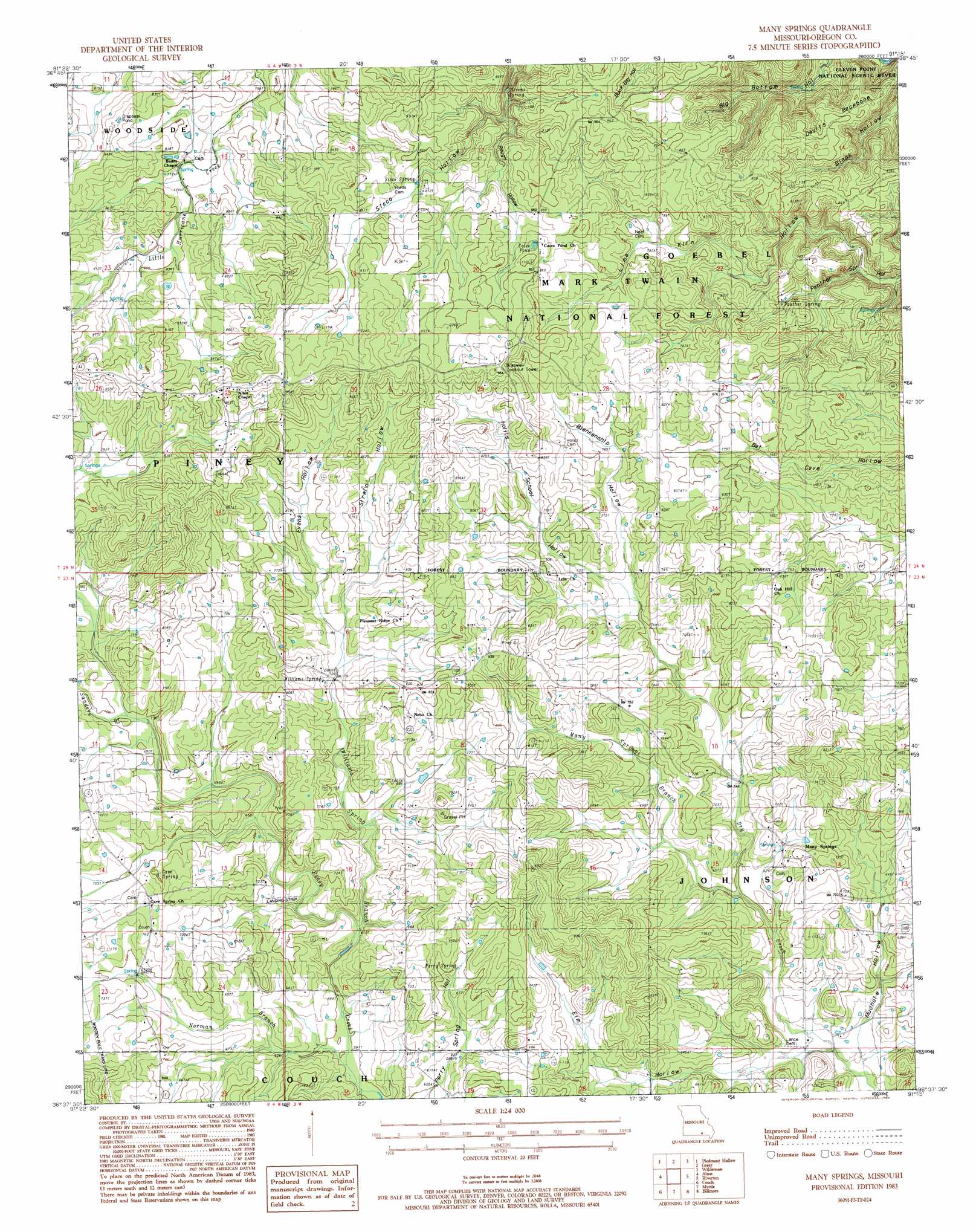
Many Springs Topo Map Missouri
To zoom in, hover over the map of Many Springs
USGS Topo Quad 36091f3 - 1:24,000 scale
| Topo Map Name: | Many Springs |
| USGS Topo Quad ID: | 36091f3 |
| Print Size: | ca. 21 1/4" wide x 27" high |
| Southeast Coordinates: | 36.625° N latitude / 91.25° W longitude |
| Map Center Coordinates: | 36.6875° N latitude / 91.3125° W longitude |
| U.S. State: | MO |
| Filename: | o36091f3.jpg |
| Download Map JPG Image: | Many Springs topo map 1:24,000 scale |
| Map Type: | Topographic |
| Topo Series: | 7.5´ |
| Map Scale: | 1:24,000 |
| Source of Map Images: | United States Geological Survey (USGS) |
| Alternate Map Versions: |
Many Springs MO 1983, updated 1984 Download PDF Buy paper map Many Springs MO 1997, updated 2000 Download PDF Buy paper map Many Springs MO 2011 Download PDF Buy paper map Many Springs MO 2015 Download PDF Buy paper map |
| FStopo: | US Forest Service topo Many Springs is available: Download FStopo PDF Download FStopo TIF |
1:24,000 Topo Quads surrounding Many Springs
Montier |
Birch Tree |
Low Wassie |
Fremont |
Van Buren South |
Thomasville |
Peidmont Hollow |
Greer |
Wilderness |
Handy |
Rover |
Alton |
Many Springs |
Riverton |
Bardley |
Thayer |
Conch |
Myrtle |
Billmore |
Gatewood |
Mammoth Spring |
Wirth |
Hardy Ne |
Dalton |
Warm Springs |
> Back to 36091e1 at 1:100,000 scale
> Back to 36090a1 at 1:250,000 scale
> Back to U.S. Topo Maps home
Many Springs topo map: Gazetteer
Many Springs: Lakes
Cates Pond elevation 268m 879′Many Springs: Populated Places
Braswell elevation 296m 971′Hollis elevation 272m 892′
Lulu elevation 236m 774′
Simpson elevation 232m 761′
Many Springs: Ridges
Devils Backbone elevation 243m 797′Many Springs: Springs
Cave Spring elevation 212m 695′Panther Spring elevation 207m 679′
Perry Spring elevation 211m 692′
Sisco Spring elevation 257m 843′
Stevens Spring elevation 259m 849′
Williams Spring elevation 222m 728′
Many Springs: Streams
Many Springs Branch elevation 179m 587′Norman Branch elevation 181m 593′
Norman Branch elevation 181m 593′
Sanders Branch elevation 209m 685′
Williams Spring Branch elevation 185m 606′
Many Springs: Summits
Wild Cat Hill elevation 281m 921′Many Springs: Valleys
Blankenship Hollow elevation 216m 708′Elm Hollow elevation 160m 524′
Evans Hollow elevation 220m 721′
Hollis School Hollow elevation 216m 708′
Lime Kiln Hollow elevation 246m 807′
Mudhole Hollow elevation 161m 528′
Rough Hollow elevation 239m 784′
Strain Hollow elevation 229m 751′
Many Springs digital topo map on disk
Buy this Many Springs topo map showing relief, roads, GPS coordinates and other geographical features, as a high-resolution digital map file on DVD: