Handy Topo Map Missouri
To zoom in, hover over the map of Handy
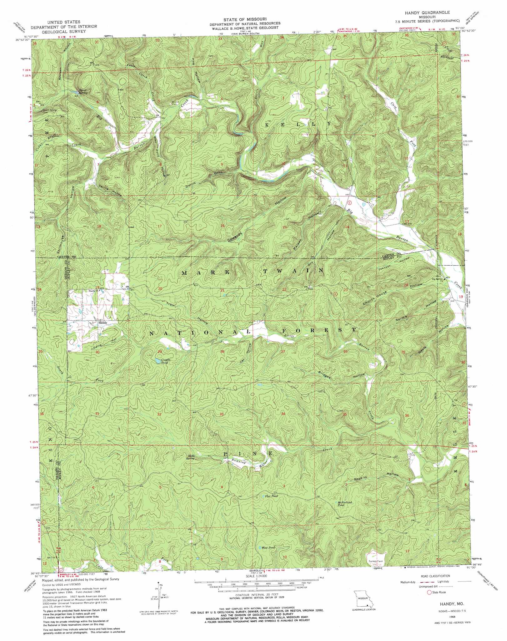
USGS Topo Quad 36091g1 - 1:24,000 scale
| Topo Map Name: | Handy |
| USGS Topo Quad ID: | 36091g1 |
| Print Size: | ca. 21 1/4" wide x 27" high |
| Southeast Coordinates: | 36.75° N latitude / 91° W longitude |
| Map Center Coordinates: | 36.8125° N latitude / 91.0625° W longitude |
| U.S. State: | MO |
| Filename: | o36091g1.jpg |
| Download Map JPG Image: | Handy topo map 1:24,000 scale |
| Map Type: | Topographic |
| Topo Series: | 7.5´ |
| Map Scale: | 1:24,000 |
| Source of Map Images: | United States Geological Survey (USGS) |
| Alternate Map Versions: |
Handy MO 1968, updated 1970 Download PDF Buy paper map Handy MO 1968, updated 1983 Download PDF Buy paper map Handy MO 1968, updated 1983 Download PDF Buy paper map Handy MO 1997, updated 1999 Download PDF Buy paper map Handy MO 2012 Download PDF Buy paper map Handy MO 2015 Download PDF Buy paper map |
| FStopo: | US Forest Service topo Handy is available: Download FStopo PDF Download FStopo TIF |
1:24,000 Topo Quads surrounding Handy
Winona |
Stegall Mountain |
Van Buren North |
Garwood |
Ellington Se |
Low Wassie |
Fremont |
Van Buren South |
Big Spring |
Hunter |
Greer |
Wilderness |
Handy |
Grandin Sw |
Grandin |
Many Springs |
Riverton |
Bardley |
Briar |
Doniphan North |
Myrtle |
Billmore |
Gatewood |
Poynor |
Doniphan South |
> Back to 36091e1 at 1:100,000 scale
> Back to 36090a1 at 1:250,000 scale
> Back to U.S. Topo Maps home
Handy topo map: Gazetteer
Handy: Basins
Buffalo Wallow elevation 246m 807′Handy: Lakes
Cupola Pond elevation 243m 797′Flat Pond elevation 231m 757′
McFarland Pond elevation 234m 767′
West Pond elevation 226m 741′
Handy: Populated Places
Barren (historical) elevation 141m 462′Handy elevation 244m 800′
Handy: Springs
Hodo Spring elevation 221m 725′Spout Spring elevation 194m 636′
Handy: Streams
Cave Fork elevation 143m 469′Cedar Bluff Creek elevation 184m 603′
Devils Run elevation 168m 551′
Fools Catch Creek elevation 176m 577′
North Fork Little Barren Creek elevation 226m 741′
Running Water Creek elevation 172m 564′
South Fork Little Barren Creek elevation 226m 741′
Handy: Valleys
Bearpen Hollow elevation 195m 639′Bridges Hollow elevation 183m 600′
Car Hollow elevation 206m 675′
Church House Hollow elevation 140m 459′
Cowards Hollow elevation 153m 501′
Davis Hollow elevation 232m 761′
Davis Hollow elevation 137m 449′
Deer Pond Hollow elevation 177m 580′
Devils Horn elevation 161m 528′
Dry Hollow elevation 147m 482′
Hog Hollow elevation 173m 567′
Johnson Hollow elevation 144m 472′
Malden Hollow elevation 152m 498′
Shut-In Hollow elevation 167m 547′
Spring Hollow elevation 192m 629′
Spring Hollow elevation 141m 462′
Stillhouse Hollow elevation 185m 606′
Tram Hollow elevation 213m 698′
White Oak Hollow elevation 202m 662′
Handy digital topo map on disk
Buy this Handy topo map showing relief, roads, GPS coordinates and other geographical features, as a high-resolution digital map file on DVD: