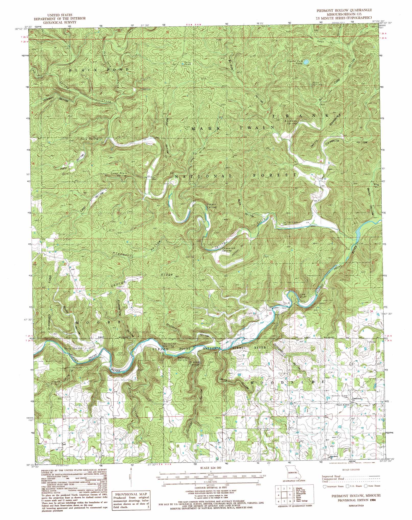
Peidmont Hollow Topo Map Missouri
To zoom in, hover over the map of Peidmont Hollow
USGS Topo Quad 36091g4 - 1:24,000 scale
| Topo Map Name: | Peidmont Hollow |
| USGS Topo Quad ID: | 36091g4 |
| Print Size: | ca. 21 1/4" wide x 27" high |
| Southeast Coordinates: | 36.75° N latitude / 91.375° W longitude |
| Map Center Coordinates: | 36.8125° N latitude / 91.4375° W longitude |
| U.S. State: | MO |
| Filename: | o36091g4.jpg |
| Download Map JPG Image: | Peidmont Hollow topo map 1:24,000 scale |
| Map Type: | Topographic |
| Topo Series: | 7.5´ |
| Map Scale: | 1:24,000 |
| Source of Map Images: | United States Geological Survey (USGS) |
| Alternate Map Versions: |
Piedmont Hollow MO 1982, updated 1983 Download PDF Buy paper map Piedmont Hollow MO 1984, updated 1985 Download PDF Buy paper map Piedmont Hollow MO 1997, updated 1999 Download PDF Buy paper map Piedmont Hollow MO 2012 Download PDF Buy paper map Piedmont Hollow MO 2015 Download PDF Buy paper map |
| FStopo: | US Forest Service topo Piedmont Hollow is available: Download FStopo PDF Download FStopo TIF |
1:24,000 Topo Quads surrounding Peidmont Hollow
Pine Crest |
Jam Up Cave |
Bartlett |
Winona |
Stegall Mountain |
Mountain View |
Montier |
Birch Tree |
Low Wassie |
Fremont |
Peace Valley |
Thomasville |
Peidmont Hollow |
Greer |
Wilderness |
Brandsville |
Rover |
Alton |
Many Springs |
Riverton |
Koshkonong |
Thayer |
Conch |
Myrtle |
Billmore |
> Back to 36091e1 at 1:100,000 scale
> Back to 36090a1 at 1:250,000 scale
> Back to U.S. Topo Maps home
Peidmont Hollow topo map: Gazetteer
Peidmont Hollow: Cliffs
Cane Bluff elevation 207m 679′Peidmont Hollow: Lakes
Elm Pond elevation 272m 892′Paty Pond elevation 281m 921′
Tupelo Gum Pond elevation 266m 872′
Peidmont Hollow: Parks
Eleven Point National Scenic River elevation 252m 826′Peidmont Hollow: Post Offices
Bandyville Post Office elevation 192m 629′Peidmont Hollow: Ridges
Devils Backbone elevation 229m 751′George Ridge elevation 276m 905′
Granddaddy Ridge elevation 275m 902′
Peidmont Hollow: Springs
Blowing Spring elevation 180m 590′Bockman Spring elevation 199m 652′
Camp House Spring elevation 219m 718′
Cooper Spring elevation 191m 626′
Graham Spring elevation 187m 613′
Paty Spring elevation 224m 734′
Posy Spring elevation 186m 610′
Roaring Spring elevation 213m 698′
Thompson Spring elevation 181m 593′
Twin Springs elevation 238m 780′
Peidmont Hollow: Streams
Bee Fork Creek elevation 214m 702′Dry Creek elevation 184m 603′
Low Wassie Creek elevation 172m 564′
Spring Creek elevation 167m 547′
Peidmont Hollow: Trails
Blue Ridge Trail elevation 249m 816′Peidmont Hollow: Valleys
Becky Hollow elevation 168m 551′Betsy Hollow elevation 198m 649′
Blubbering Hollow elevation 191m 626′
Buck Hollow elevation 187m 613′
Bull Camp Hollow elevation 185m 606′
Camp Hollow elevation 199m 652′
Cane Bluff Hollow elevation 175m 574′
Cave Spring Hollow elevation 187m 613′
Denny Hollow elevation 177m 580′
Doniphan Hollow elevation 174m 570′
Graham Hollow elevation 186m 610′
Hog Hollow elevation 217m 711′
Jackson Hollow elevation 179m 587′
Jenny Hollow elevation 192m 629′
Johnson Hollow elevation 218m 715′
Mine Hollow elevation 182m 597′
Orchard Hollow elevation 184m 603′
Paty Hollow elevation 210m 688′
Piedmont Hollow elevation 193m 633′
Round Hollow elevation 185m 606′
Sheep Ranch Hollow elevation 230m 754′
Threemile Hollow elevation 174m 570′
Well Hollow elevation 230m 754′
Wolfpen Hollow elevation 195m 639′
Peidmont Hollow digital topo map on disk
Buy this Peidmont Hollow topo map showing relief, roads, GPS coordinates and other geographical features, as a high-resolution digital map file on DVD: