Pyatt Topo Map Arkansas
To zoom in, hover over the map of Pyatt
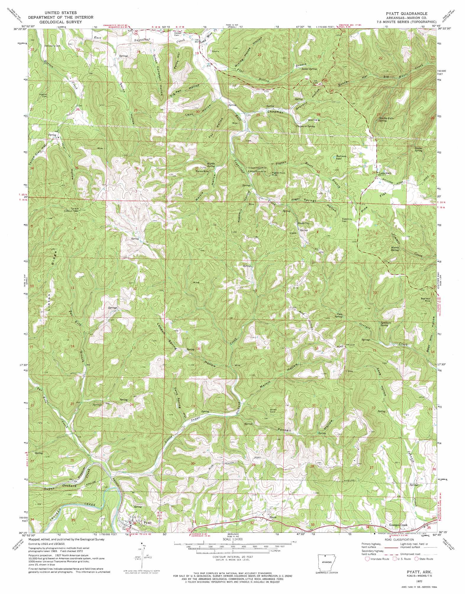
USGS Topo Quad 36092c7 - 1:24,000 scale
| Topo Map Name: | Pyatt |
| USGS Topo Quad ID: | 36092c7 |
| Print Size: | ca. 21 1/4" wide x 27" high |
| Southeast Coordinates: | 36.25° N latitude / 92.75° W longitude |
| Map Center Coordinates: | 36.3125° N latitude / 92.8125° W longitude |
| U.S. State: | AR |
| Filename: | o36092c7.jpg |
| Download Map JPG Image: | Pyatt topo map 1:24,000 scale |
| Map Type: | Topographic |
| Topo Series: | 7.5´ |
| Map Scale: | 1:24,000 |
| Source of Map Images: | United States Geological Survey (USGS) |
| Alternate Map Versions: |
Pyatt AR 1972, updated 1973 Download PDF Buy paper map Pyatt AR 2011 Download PDF Buy paper map Pyatt AR 2014 Download PDF Buy paper map |
1:24,000 Topo Quads surrounding Pyatt
Mincy |
Protem Sw |
Protem |
Theodosia |
Isabella |
Omaha Ne |
Diamond City |
Peel |
Cotter Nw |
Bull Shoals |
Bergman |
Zinc |
Pyatt |
Cotter Sw |
Cotter |
Harrison |
Everton |
Bruno |
Yellville |
Rea Valley |
Hasty |
Western Grove |
Saint Joe |
Maumee |
Cozahome |
> Back to 36092a1 at 1:100,000 scale
> Back to 36092a1 at 1:250,000 scale
> Back to U.S. Topo Maps home
Pyatt topo map: Gazetteer
Pyatt: Flats
Pine Flat elevation 376m 1233′Pyatt: Lakes
Waltman Pond elevation 363m 1190′Pyatt: Mines
Bear Hill Mine elevation 315m 1033′Copperhead Mine elevation 306m 1003′
Markle Mine elevation 305m 1000′
Pigeon Roost Mine elevation 312m 1023′
Pilot Rock Mine elevation 300m 984′
Pyatt: Populated Places
Dodd City elevation 335m 1099′Georges Creek elevation 208m 682′
Lakeway elevation 368m 1207′
Snow elevation 286m 938′
Pyatt: Ridges
Linton Ridge elevation 380m 1246′Pyatt: Springs
Chapman Spring elevation 305m 1000′Coon Spring elevation 301m 987′
Grever Spring elevation 320m 1049′
Marble Falls Spring elevation 332m 1089′
Markle Spring elevation 307m 1007′
Morris Spring elevation 329m 1079′
Sailor Spring elevation 316m 1036′
Sycamore Spring elevation 280m 918′
Pyatt: Streams
Flat Hollow Branch elevation 254m 833′Lead Mine Creek elevation 247m 810′
Little Sugar Creek elevation 219m 718′
Pigeon Roost Branch elevation 297m 974′
Sugar Orchard Creek elevation 221m 725′
Tar Kiln Branch elevation 234m 767′
Tar Kiln Creek elevation 224m 734′
Pyatt: Summits
Clark Hill elevation 408m 1338′Pyatt: Valleys
Angel Springs Hollow elevation 319m 1046′Bear Hill Hollow elevation 245m 803′
Boozer Hollow elevation 273m 895′
Cave Hollow elevation 234m 767′
Chapman Hollow elevation 269m 882′
Fox Hollow elevation 267m 875′
Gravelly Hollow elevation 291m 954′
Green Campbell Hollow elevation 245m 803′
Iola Hollow elevation 285m 935′
Leon Hollow elevation 264m 866′
London Spring Hollow elevation 270m 885′
Markle Hollow elevation 290m 951′
Martin Hollow elevation 259m 849′
Mining House Hollow elevation 270m 885′
Nokomis Hollow elevation 299m 980′
Pannell Hollow elevation 269m 882′
Parks Hollow elevation 253m 830′
Pig Pen Hollow elevation 259m 849′
Salina Hollow elevation 236m 774′
Sand Spring Hollow elevation 240m 787′
Tallow Clay Hollow elevation 285m 935′
Pyatt digital topo map on disk
Buy this Pyatt topo map showing relief, roads, GPS coordinates and other geographical features, as a high-resolution digital map file on DVD: