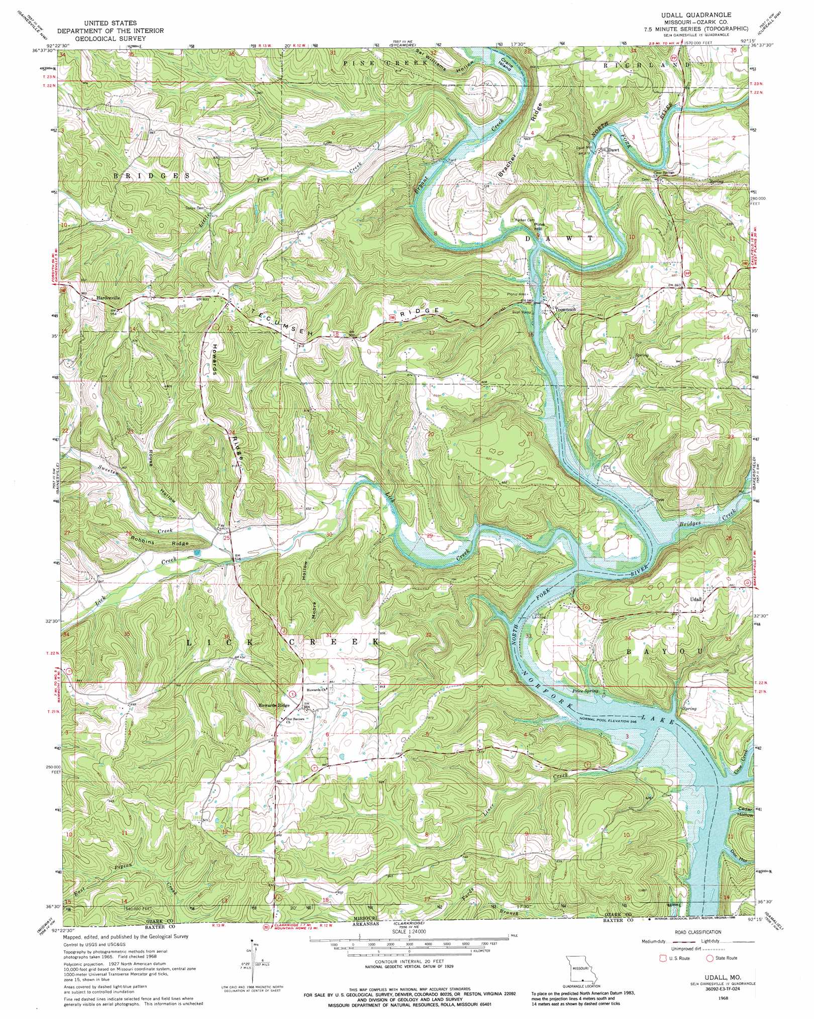
Udall Topo Map Missouri
To zoom in, hover over the map of Udall
USGS Topo Quad 36092e3 - 1:24,000 scale
| Topo Map Name: | Udall |
| USGS Topo Quad ID: | 36092e3 |
| Print Size: | ca. 21 1/4" wide x 27" high |
| Southeast Coordinates: | 36.5° N latitude / 92.25° W longitude |
| Map Center Coordinates: | 36.5625° N latitude / 92.3125° W longitude |
| U.S. State: | MO |
| Filename: | o36092e3.jpg |
| Download Map JPG Image: | Udall topo map 1:24,000 scale |
| Map Type: | Topographic |
| Topo Series: | 7.5´ |
| Map Scale: | 1:24,000 |
| Source of Map Images: | United States Geological Survey (USGS) |
| Alternate Map Versions: |
Udall MO 1968, updated 1969 Download PDF Buy paper map Udall MO 1968, updated 1986 Download PDF Buy paper map Udall MO 2012 Download PDF Buy paper map Udall MO 2015 Download PDF Buy paper map |
1:24,000 Topo Quads surrounding Udall
Wasola |
Rockbridge |
Gentryville |
Dora |
Siloam Springs |
Willhoit |
Gainesville Nw |
Sycamore |
Cureall Nw |
Pottersville |
Isabella |
Gainesville |
Udall |
Bakersfield |
Caulfield |
Bull Shoals |
Midway |
Clarkridge |
Gamaliel |
Gepp |
Cotter |
Mountain Home West |
Mountain Home East |
Norfork Dam North |
Elizabeth |
> Back to 36092e1 at 1:100,000 scale
> Back to 36092a1 at 1:250,000 scale
> Back to U.S. Topo Maps home
Udall topo map: Gazetteer
Udall: Crossings
Billy Buster Ford (historical) elevation 182m 597′Gifford Ford elevation 179m 587′
Poe Ford (historical) elevation 167m 547′
Pumphrey Ford (historical) elevation 167m 547′
Udall: Dams
Dawt Mill Pond Dam elevation 179m 587′Udall: Islands
Crane Island elevation 178m 583′Udall: Populated Places
Dawt elevation 185m 606′Dawt Mill elevation 179m 587′
Fay elevation 201m 659′
Hardenville elevation 296m 971′
Howards Ridge elevation 268m 879′
Prestonia elevation 282m 925′
Tecumseh elevation 186m 610′
Udall elevation 260m 853′
Udall Landing elevation 172m 564′
Udall: Post Offices
Prestonia Post Office (historical) elevation 282m 925′Udall: Reservoirs
Dawt Mill Pond elevation 179m 587′Udall: Ridges
Bracher Ridge elevation 266m 872′Howards Ridge elevation 267m 875′
Robbins Ridge elevation 231m 757′
Tecumseh Ridge elevation 270m 885′
Udall: Springs
Price Spring elevation 174m 570′Udall: Streams
Bridges Creek elevation 170m 557′Bryant Creek elevation 170m 557′
Cane Creek elevation 167m 547′
Fords Branch elevation 196m 643′
Lick Creek elevation 167m 547′
Liner Creek elevation 167m 547′
Little Pine Creek elevation 176m 577′
Sweeten Creek elevation 183m 600′
Udall: Summits
Pine Hill elevation 199m 652′Udall: Valleys
Big Hollow elevation 182m 597′Cedar Hollow elevation 167m 547′
Doc Hollow elevation 167m 547′
Moore Hollow elevation 181m 593′
Provo Hollow elevation 167m 547′
Rouse Hollow elevation 187m 613′
Sal Williams Hollow elevation 181m 593′
Udall digital topo map on disk
Buy this Udall topo map showing relief, roads, GPS coordinates and other geographical features, as a high-resolution digital map file on DVD: