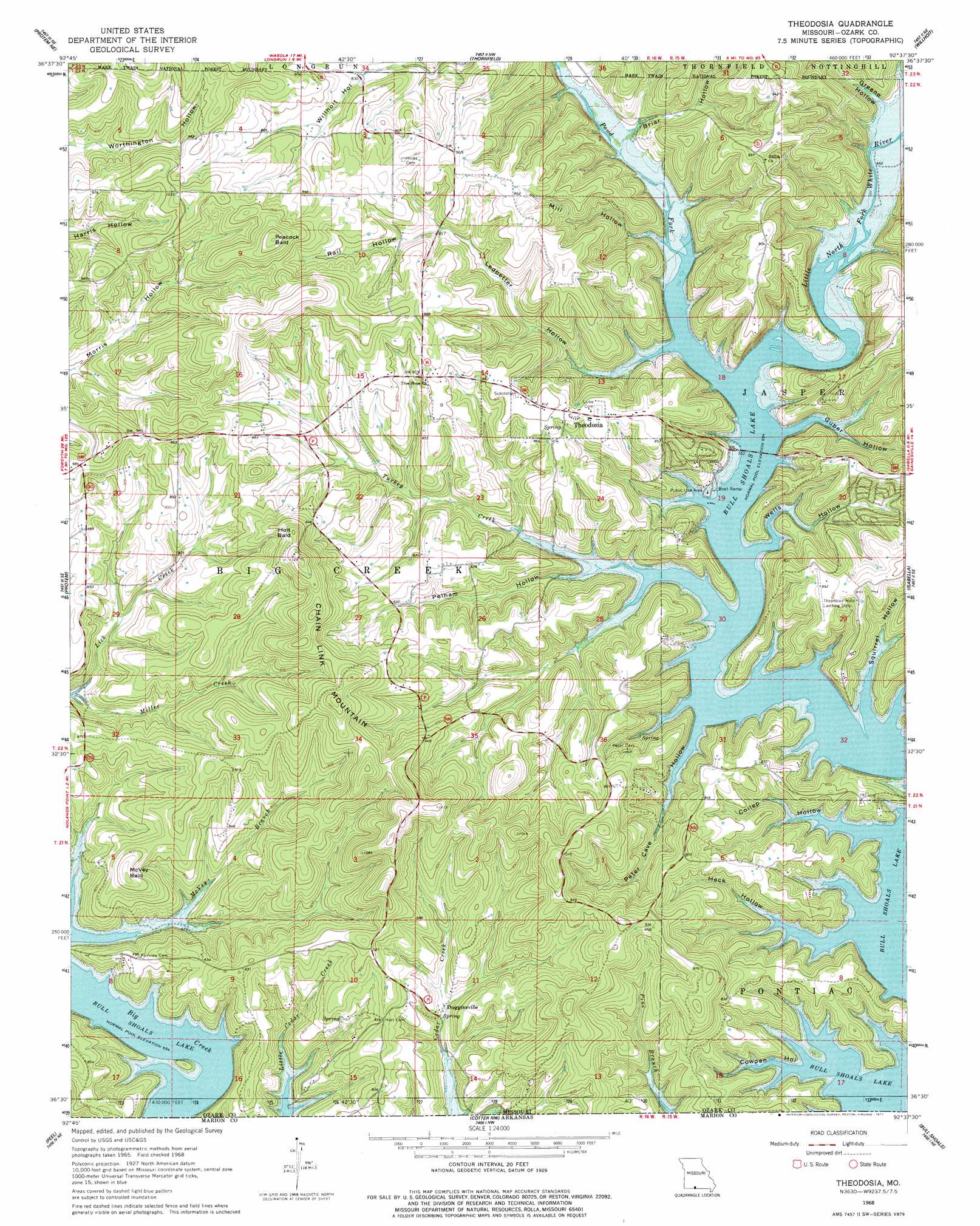
Theodosia Topo Map Missouri
To zoom in, hover over the map of Theodosia
USGS Topo Quad 36092e6 - 1:24,000 scale
| Topo Map Name: | Theodosia |
| USGS Topo Quad ID: | 36092e6 |
| Print Size: | ca. 21 1/4" wide x 27" high |
| Southeast Coordinates: | 36.5° N latitude / 92.625° W longitude |
| Map Center Coordinates: | 36.5625° N latitude / 92.6875° W longitude |
| U.S. State: | MO |
| Filename: | o36092e6.jpg |
| Download Map JPG Image: | Theodosia topo map 1:24,000 scale |
| Map Type: | Topographic |
| Topo Series: | 7.5´ |
| Map Scale: | 1:24,000 |
| Source of Map Images: | United States Geological Survey (USGS) |
| Alternate Map Versions: |
Theodosia MO 1968, updated 1970 Download PDF Buy paper map Theodosia MO 1968, updated 1977 Download PDF Buy paper map Theodosia MO 2004, updated 2006 Download PDF Buy paper map Theodosia MO 2012 Download PDF Buy paper map Theodosia MO 2015 Download PDF Buy paper map |
| FStopo: | US Forest Service topo Theodosia is available: Download FStopo PDF Download FStopo TIF |
1:24,000 Topo Quads surrounding Theodosia
Bradleyville |
Brownbranch |
Smallett |
Wasola |
Rockbridge |
Hilda |
Protem Ne |
Thornfield |
Willhoit |
Gainesville Nw |
Protem Sw |
Protem |
Theodosia |
Isabella |
Gainesville |
Diamond City |
Peel |
Cotter Nw |
Bull Shoals |
Midway |
Zinc |
Pyatt |
Cotter Sw |
Cotter |
Mountain Home West |
> Back to 36092e1 at 1:100,000 scale
> Back to 36092a1 at 1:250,000 scale
> Back to U.S. Topo Maps home
Theodosia topo map: Gazetteer
Theodosia: Airports
Lost Mine Airport elevation 246m 807′Theodosia Hills Landing strip elevation 269m 882′
Theodosia: Crossings
Neasby Ford (historical) elevation 199m 652′Theodosia: Populated Places
Dugginsville elevation 223m 731′Lutie elevation 275m 902′
Sundown elevation 235m 770′
Theodosia elevation 271m 889′
Theodosia (historical) elevation 199m 652′
Theodosia: Streams
McVey Branch elevation 200m 656′Miller Creek elevation 213m 698′
Pond Fork elevation 199m 652′
Turkey Creek elevation 199m 652′
Theodosia: Summits
Chain Link Mountain elevation 343m 1125′Holt Bald elevation 336m 1102′
McVey Bald elevation 288m 944′
Peacock Bald elevation 348m 1141′
Theodosia: Valleys
Briar Hollow elevation 207m 679′Coilep Hollow elevation 199m 652′
Cole Hollow elevation 206m 675′
Cowpen Hollow elevation 199m 652′
Greene Hollow elevation 205m 672′
Guber Hollow elevation 199m 652′
Heck Hollow elevation 199m 652′
Ledbetter Hollow elevation 199m 652′
Mill Hollow elevation 201m 659′
Pelham Hollow elevation 203m 666′
Peter Cave Hollow elevation 199m 652′
Rail Hollow elevation 248m 813′
Squirrel Hollow elevation 199m 652′
Wells Hollow elevation 199m 652′
Theodosia digital topo map on disk
Buy this Theodosia topo map showing relief, roads, GPS coordinates and other geographical features, as a high-resolution digital map file on DVD: