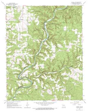
Cureall Nw Topo Map Missouri
To zoom in, hover over the map of Cureall Nw
USGS Topo Quad 36092f2 - 1:24,000 scale
| Topo Map Name: | Cureall Nw |
| USGS Topo Quad ID: | 36092f2 |
| Print Size: | ca. 21 1/4" wide x 27" high |
| Southeast Coordinates: | 36.625° N latitude / 92.125° W longitude |
| Map Center Coordinates: | 36.6875° N latitude / 92.1875° W longitude |
| U.S. State: | MO |
| Filename: | o36092f2.jpg |
| Download Map JPG Image: | Cureall Nw topo map 1:24,000 scale |
| Map Type: | Topographic |
| Topo Series: | 7.5´ |
| Map Scale: | 1:24,000 |
| Source of Map Images: | United States Geological Survey (USGS) |
| Alternate Map Versions: |
Cureall NW MO 1968, updated 1969 Download PDF Buy paper map Cureall NW MO 1968, updated 1969 Download PDF Buy paper map Cureall NW MO 2004, updated 2006 Download PDF Buy paper map Cureall NW MO 2012 Download PDF Buy paper map Cureall NW MO 2015 Download PDF Buy paper map |
| FStopo: | US Forest Service topo Cureall NW is available: Download FStopo PDF Download FStopo TIF |
1:24,000 Topo Quads surrounding Cureall Nw
> Back to 36092e1 at 1:100,000 scale
> Back to 36092a1 at 1:250,000 scale
> Back to U.S. Topo Maps home
Cureall Nw topo map: Gazetteer
Cureall Nw: Airports
Sunburst Ranch Airport elevation 244m 800′Cureall Nw: Capes
Turkey Point elevation 285m 935′Cureall Nw: Crossings
Duncan Ford elevation 202m 662′Cureall Nw: Falls
The Falls elevation 196m 643′Cureall Nw: Parks
Blair Bridge Park elevation 196m 643′Cureall Nw: Populated Places
Althea elevation 190m 623′Bird Springs elevation 268m 879′
Cross Roads elevation 301m 987′
Dormis elevation 257m 843′
High Place Lookout Tower elevation 318m 1043′
Oak Mound elevation 288m 944′
Cureall Nw: Ridges
Bond Ridge elevation 290m 951′Collins Ridge elevation 300m 984′
Creek Pond Ridge elevation 300m 984′
Devils Blackbone elevation 283m 928′
Dividing Ridge elevation 291m 954′
Low Gap Ridge elevation 306m 1003′
McGarr Ridge elevation 301m 987′
Robinson Ridge elevation 294m 964′
Taylor Ridge elevation 293m 961′
Cureall Nw: Springs
Althea Spring elevation 191m 626′Amber Spring elevation 264m 866′
Bird Springs elevation 268m 879′
Cave Spring elevation 229m 751′
Clapp Spring elevation 275m 902′
Collins Spring elevation 247m 810′
Fogey Spring elevation 241m 790′
Lane Spring elevation 217m 711′
McGarr Spring elevation 246m 807′
Moss Spring elevation 257m 843′
North Fork Springs elevation 201m 659′
Rainbow Spring elevation 201m 659′
Shipley Spring elevation 241m 790′
Spoon Spring elevation 236m 774′
Wilder Spring elevation 208m 682′
Cureall Nw: Streams
Arnold Branch elevation 205m 672′Crooked Branch elevation 207m 679′
James Branch elevation 183m 600′
Spring Creek elevation 185m 606′
Cureall Nw: Summits
Duncan Hill elevation 277m 908′Cureall Nw: Valleys
Ball Pond Hollow elevation 201m 659′Bill Hollow elevation 223m 731′
Bond Hollow elevation 200m 656′
Carrol Hollow elevation 219m 718′
Cave Spring Hollow elevation 193m 633′
Click Hollow elevation 196m 643′
Creek Pond Hollow elevation 207m 679′
Fogey Cave Hollow elevation 207m 679′
Grannis Hollow elevation 242m 793′
Graveyard Hollow elevation 203m 666′
Hall Pond Hollow elevation 207m 679′
Kelly Hollow elevation 199m 652′
Mary Hollow elevation 242m 793′
McGarr Hollow elevation 243m 797′
Piney Point Hollow elevation 206m 675′
Pond Hollow elevation 201m 659′
Portwood Hollow elevation 201m 659′
Potato Cave Hollow elevation 236m 774′
Raccoon Hollow elevation 207m 679′
Ruth Hollow elevation 204m 669′
Sawmill Hollow elevation 206m 675′
Sawmill Hollow elevation 213m 698′
Sheriff Hollow elevation 202m 662′
Smith Hollow elevation 182m 597′
Spoon Hollow elevation 200m 656′
Taylor Hollow elevation 209m 685′
Cureall Nw digital topo map on disk
Buy this Cureall Nw topo map showing relief, roads, GPS coordinates and other geographical features, as a high-resolution digital map file on DVD:


