Dyestone Mountain Topo Map Missouri
To zoom in, hover over the map of Dyestone Mountain
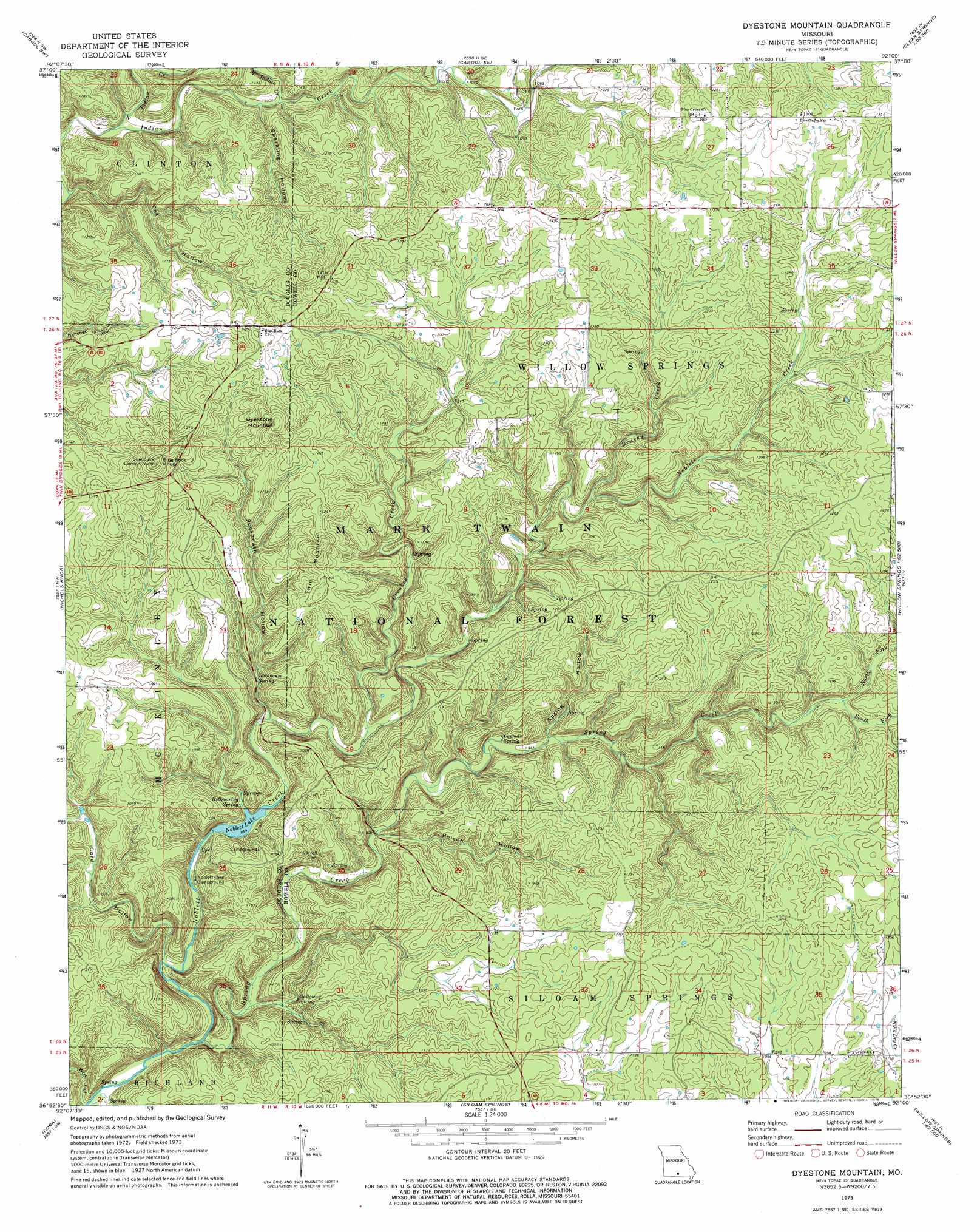
USGS Topo Quad 36092h1 - 1:24,000 scale
| Topo Map Name: | Dyestone Mountain |
| USGS Topo Quad ID: | 36092h1 |
| Print Size: | ca. 21 1/4" wide x 27" high |
| Southeast Coordinates: | 36.875° N latitude / 92° W longitude |
| Map Center Coordinates: | 36.9375° N latitude / 92.0625° W longitude |
| U.S. State: | MO |
| Filename: | o36092h1.jpg |
| Download Map JPG Image: | Dyestone Mountain topo map 1:24,000 scale |
| Map Type: | Topographic |
| Topo Series: | 7.5´ |
| Map Scale: | 1:24,000 |
| Source of Map Images: | United States Geological Survey (USGS) |
| Alternate Map Versions: |
Dyestone Mountain MO 2004, updated 2006 Download PDF Buy paper map Dyestone Mountain MO 2012 Download PDF Buy paper map Dyestone Mountain MO 2015 Download PDF Buy paper map |
| FStopo: | US Forest Service topo Dyestone Mountain is available: Download FStopo PDF Download FStopo TIF |
1:24,000 Topo Quads surrounding Dyestone Mountain
Mountain Grove North |
Cabool Nw |
Cabool Ne |
Elk Creek |
Eunice |
Mountain Grove South |
Cabool Sw |
Cabool Se |
Willow Springs North |
Clear Springs |
Vanzant |
Nichols Knob |
Dyestone Mountain |
Willow Springs South |
Trask |
Gentryville |
Dora |
Siloam Springs |
Pomona |
White Church |
Sycamore |
Cureall Nw |
Pottersville |
South Fork |
West Plains |
> Back to 36092e1 at 1:100,000 scale
> Back to 36092a1 at 1:250,000 scale
> Back to U.S. Topo Maps home
Dyestone Mountain topo map: Gazetteer
Dyestone Mountain: Areas
Ozarks elevation 366m 1200′Dyestone Mountain: Dams
Noblett Lake Dam elevation 284m 931′Dyestone Mountain: Forests
Willow Springs Ranger District elevation 320m 1049′Dyestone Mountain: Parks
Carmen Springs Wildlife Refuge Management Area elevation 343m 1125′Dyestone Mountain: Reservoirs
Noblett Lake elevation 284m 931′Dyestone Mountain: Springs
Carman Spring elevation 298m 977′Galloway Spring elevation 276m 905′
Group Camp Spring elevation 261m 856′
Hellroaring Spring elevation 267m 875′
Rockhouse Spring elevation 276m 905′
Dyestone Mountain: Streams
Brushy Creek elevation 316m 1036′Crooked Creek elevation 274m 898′
Little Indian Creek elevation 297m 974′
Middle Indian Creek elevation 302m 990′
Noblett Creek elevation 250m 820′
North Fork Spring Creek elevation 319m 1046′
South Fork Spring Creek elevation 319m 1046′
Dyestone Mountain: Summits
Blue Buck Knob elevation 442m 1450′Dyestone Mountain elevation 424m 1391′
Tater Hill elevation 438m 1437′
Twin Mountain elevation 400m 1312′
Dyestone Mountain: Valleys
Cord Hollow elevation 256m 839′Fox Hollow elevation 291m 954′
Poison Hollow elevation 274m 898′
Rockhouse Hollow elevation 268m 879′
Sparkling Hollow elevation 304m 997′
Spring Hollow elevation 288m 944′
Wolf Hollow elevation 251m 823′
Dyestone Mountain digital topo map on disk
Buy this Dyestone Mountain topo map showing relief, roads, GPS coordinates and other geographical features, as a high-resolution digital map file on DVD: