Kingston Topo Map Arkansas
To zoom in, hover over the map of Kingston
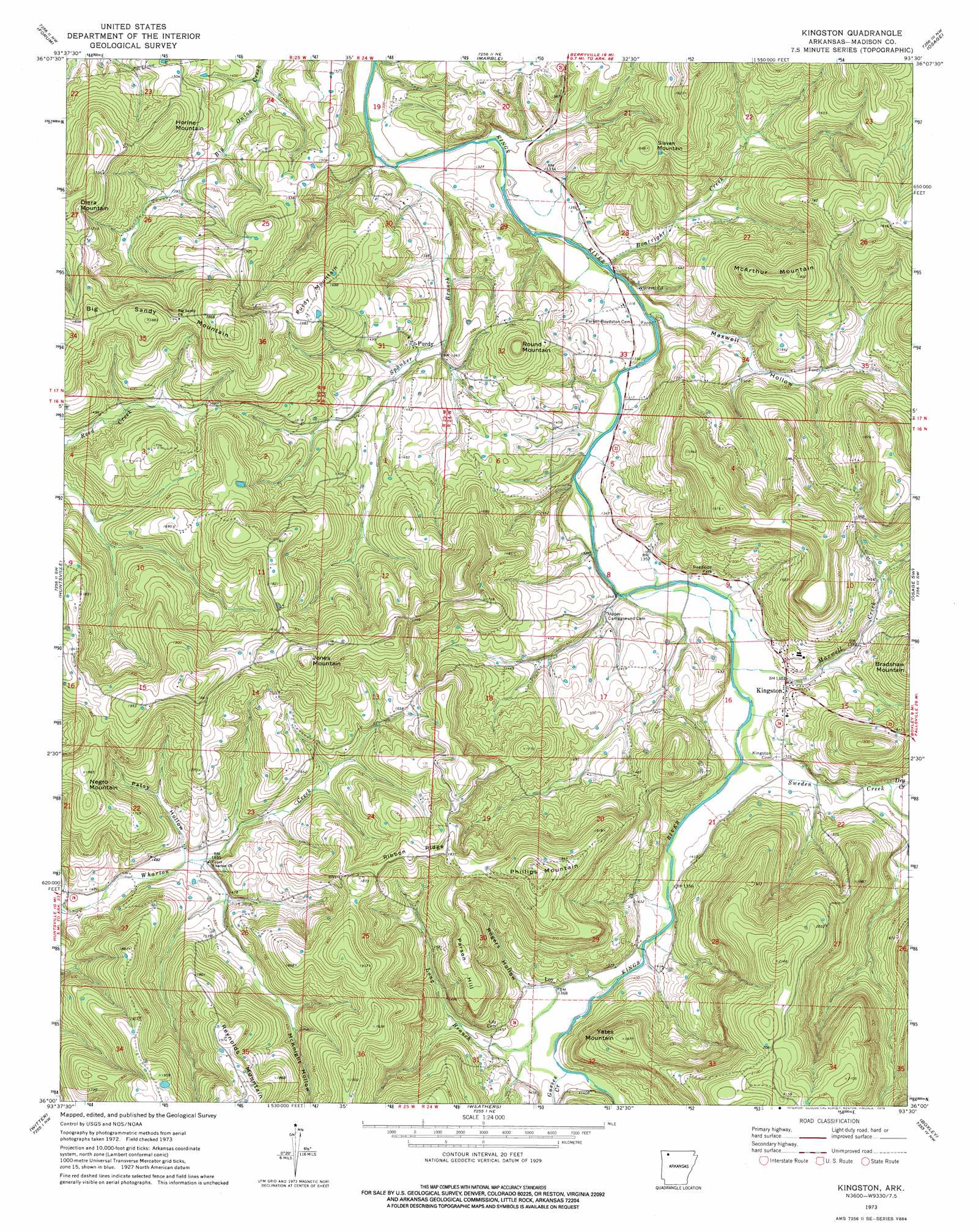
USGS Topo Quad 36093a5 - 1:24,000 scale
| Topo Map Name: | Kingston |
| USGS Topo Quad ID: | 36093a5 |
| Print Size: | ca. 21 1/4" wide x 27" high |
| Southeast Coordinates: | 36° N latitude / 93.5° W longitude |
| Map Center Coordinates: | 36.0625° N latitude / 93.5625° W longitude |
| U.S. State: | AR |
| Filename: | o36093a5.jpg |
| Download Map JPG Image: | Kingston topo map 1:24,000 scale |
| Map Type: | Topographic |
| Topo Series: | 7.5´ |
| Map Scale: | 1:24,000 |
| Source of Map Images: | United States Geological Survey (USGS) |
| Alternate Map Versions: |
Kingston AR 1973, updated 1976 Download PDF Buy paper map Kingston AR 2011 Download PDF Buy paper map Kingston AR 2014 Download PDF Buy paper map |
1:24,000 Topo Quads surrounding Kingston
Sandstone Mountain |
Rockhouse |
Berryville |
Green Forest |
Alpena |
Hindsville |
Forum |
Marble |
Osage |
Osage Ne |
Hartwell |
Huntsville |
Kingston |
Osage Sw |
Ponca |
Japton |
Witter |
Weathers |
Boxley |
Murray |
Saint Paul |
Pettigrew |
Boston |
Fallsville |
Swain |
> Back to 36093a1 at 1:100,000 scale
> Back to 36092a1 at 1:250,000 scale
> Back to U.S. Topo Maps home
Kingston topo map: Gazetteer
Kingston: Populated Places
Kingston elevation 413m 1354′Loy elevation 418m 1371′
Purdy elevation 423m 1387′
Truth (historical) elevation 560m 1837′
Kingston: Ridges
Ribbon Ridge elevation 554m 1817′Kingston: Streams
Boatright Creek elevation 393m 1289′Dry Creek elevation 417m 1368′
Gusses Creek elevation 415m 1361′
Long Branch elevation 409m 1341′
Maxwell Creek elevation 404m 1325′
Spanker Branch elevation 388m 1272′
Sweden Creek elevation 406m 1332′
Kingston: Summits
Big Sandy Mountain elevation 572m 1876′Horine Mountain elevation 510m 1673′
Jones Mountain elevation 620m 2034′
McArthur Mountain elevation 575m 1886′
Negro Mountain elevation 567m 1860′
Parson Hill elevation 540m 1771′
Phillips Mountain elevation 631m 2070′
Purdy Mountain elevation 515m 1689′
Reynolds Mountain elevation 596m 1955′
Round Mountain elevation 501m 1643′
Slaven Mountain elevation 503m 1650′
Yates Mountain elevation 565m 1853′
Kingston: Valleys
Maxwell Hollow elevation 396m 1299′McKnight Hollow elevation 446m 1463′
Patsy Hollow elevation 440m 1443′
Rogers Hollow elevation 419m 1374′
Tate Hollow elevation 397m 1302′
Kingston digital topo map on disk
Buy this Kingston topo map showing relief, roads, GPS coordinates and other geographical features, as a high-resolution digital map file on DVD: