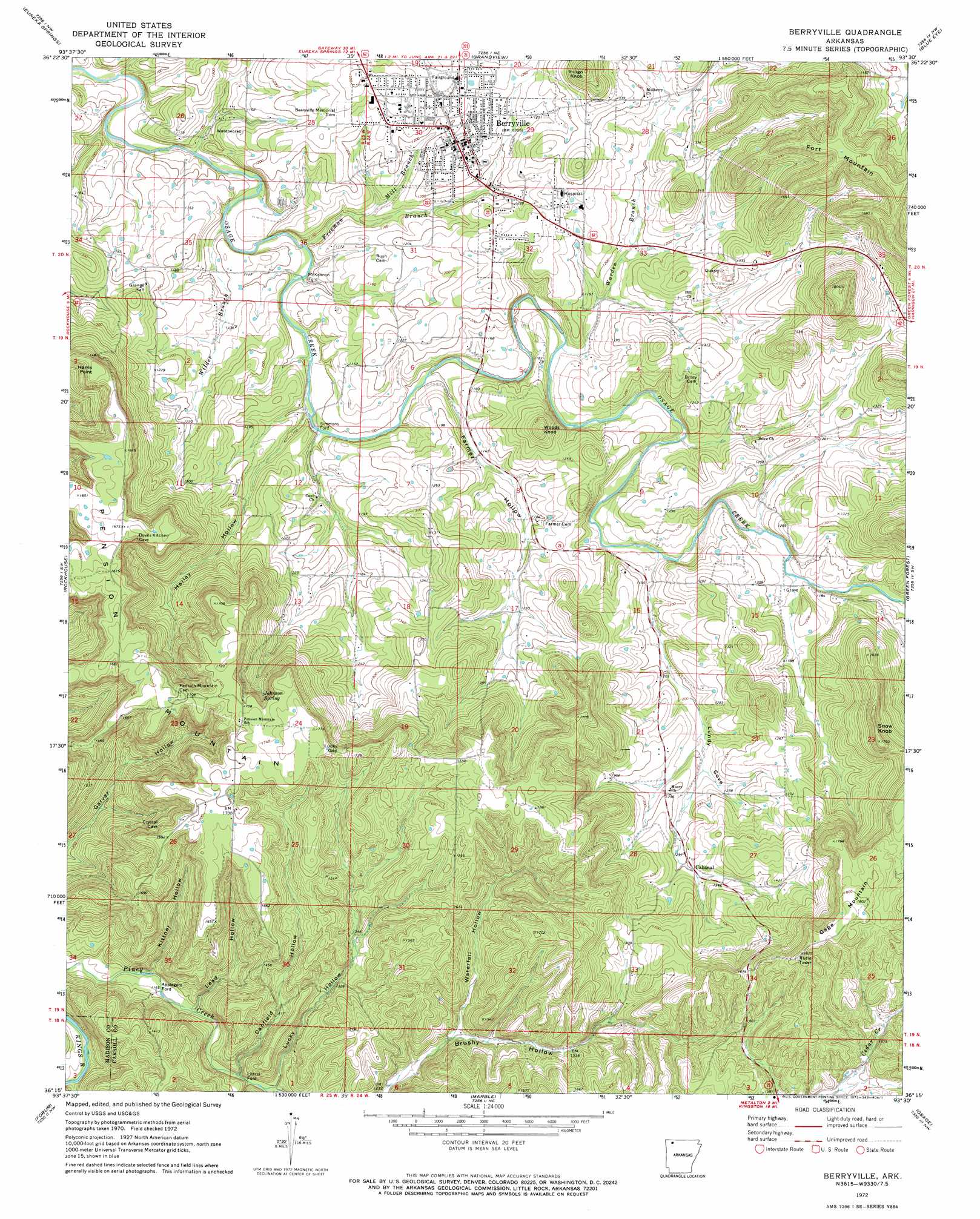
Berryville Topo Map Arkansas
To zoom in, hover over the map of Berryville
USGS Topo Quad 36093c5 - 1:24,000 scale
| Topo Map Name: | Berryville |
| USGS Topo Quad ID: | 36093c5 |
| Print Size: | ca. 21 1/4" wide x 27" high |
| Southeast Coordinates: | 36.25° N latitude / 93.5° W longitude |
| Map Center Coordinates: | 36.3125° N latitude / 93.5625° W longitude |
| U.S. State: | AR |
| Filename: | o36093c5.jpg |
| Download Map JPG Image: | Berryville topo map 1:24,000 scale |
| Map Type: | Topographic |
| Topo Series: | 7.5´ |
| Map Scale: | 1:24,000 |
| Source of Map Images: | United States Geological Survey (USGS) |
| Alternate Map Versions: |
Berryville AR 1972, updated 1973 Download PDF Buy paper map Berryville AR 2011 Download PDF Buy paper map Berryville AR 2014 Download PDF Buy paper map |
1:24,000 Topo Quads surrounding Berryville
Eagle Rock |
Golden |
Viola |
Lampe |
Table Rock Dam |
Beaver |
Eureka Springs |
Grandview |
Blue Eye |
Denver |
Sandstone Mountain |
Rockhouse |
Berryville |
Green Forest |
Alpena |
Hindsville |
Forum |
Marble |
Osage |
Osage Ne |
Hartwell |
Huntsville |
Kingston |
Osage Sw |
Ponca |
> Back to 36093a1 at 1:100,000 scale
> Back to 36092a1 at 1:250,000 scale
> Back to U.S. Topo Maps home
Berryville topo map: Gazetteer
Berryville: Airports
Carroll General Hospital Heliport elevation 391m 1282′Berryville: Cliffs
Harris Point elevation 510m 1673′Berryville: Crossings
Applegate Ford elevation 353m 1158′Littrel Ford elevation 361m 1184′
McKennon Ford elevation 321m 1053′
Simmons Ford elevation 325m 1066′
Berryville: Dams
Jackson Lake Dam elevation 383m 1256′Berryville: Gaps
Lucky Gap elevation 507m 1663′Berryville: Populated Places
Berryville elevation 379m 1243′Cabanal elevation 397m 1302′
Berryville: Reservoirs
Jackson Lake elevation 383m 1256′Berryville: Springs
Johnson Spring elevation 486m 1594′Berryville: Streams
Freeman Branch elevation 320m 1049′Mill Branch elevation 331m 1085′
Warden Branch elevation 332m 1089′
Wilder Branch elevation 318m 1043′
Berryville: Summits
Fort Mountain elevation 509m 1669′Gage Mountain elevation 547m 1794′
Indigo Knob elevation 484m 1587′
Pension Mountain elevation 507m 1663′
Snow Knob elevation 468m 1535′
Woods Knob elevation 429m 1407′
Berryville: Valleys
Canfield Hollow elevation 364m 1194′Farmer Hollow elevation 333m 1092′
Hailey Hollow elevation 337m 1105′
Kittner Hollow elevation 358m 1174′
Lead Hollow elevation 360m 1181′
Lucky Hollow elevation 378m 1240′
Sugarcamp Hollow elevation 347m 1138′
Waterfall Hollow elevation 387m 1269′
Berryville digital topo map on disk
Buy this Berryville topo map showing relief, roads, GPS coordinates and other geographical features, as a high-resolution digital map file on DVD: