Branson Topo Map Missouri
To zoom in, hover over the map of Branson
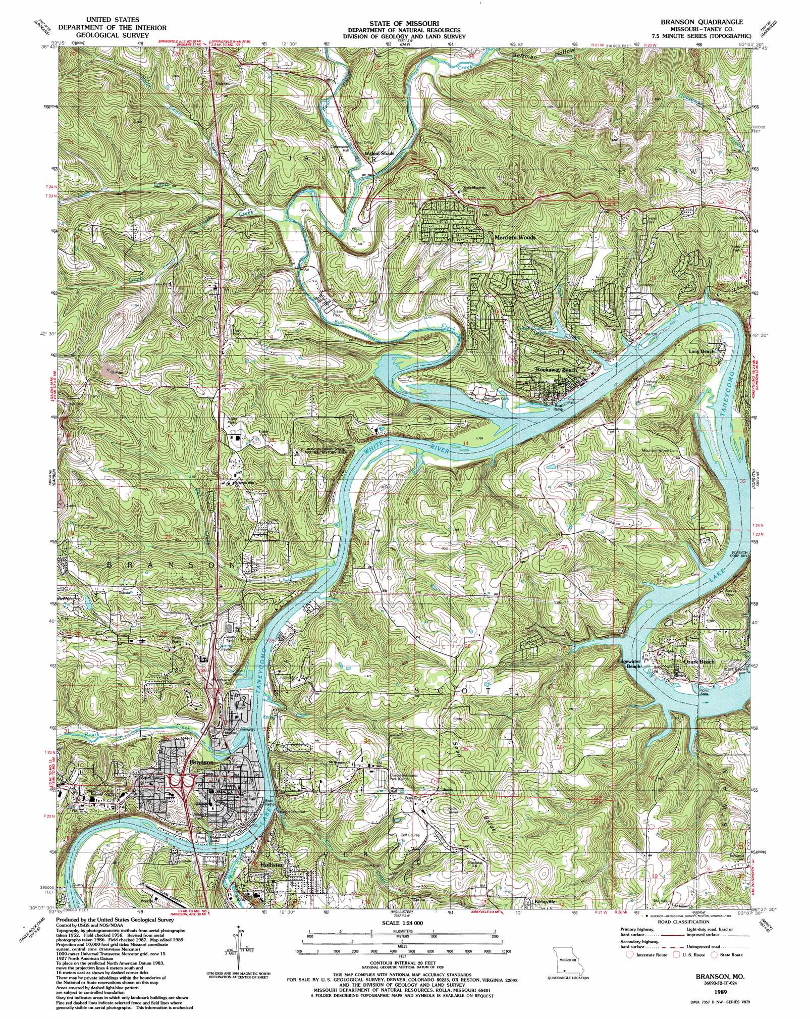
USGS Topo Quad 36093f2 - 1:24,000 scale
| Topo Map Name: | Branson |
| USGS Topo Quad ID: | 36093f2 |
| Print Size: | ca. 21 1/4" wide x 27" high |
| Southeast Coordinates: | 36.625° N latitude / 93.125° W longitude |
| Map Center Coordinates: | 36.6875° N latitude / 93.1875° W longitude |
| U.S. State: | MO |
| Filename: | o36093f2.jpg |
| Download Map JPG Image: | Branson topo map 1:24,000 scale |
| Map Type: | Topographic |
| Topo Series: | 7.5´ |
| Map Scale: | 1:24,000 |
| Source of Map Images: | United States Geological Survey (USGS) |
| Alternate Map Versions: |
Branson MO 1956, updated 1957 Download PDF Buy paper map Branson MO 1956, updated 1970 Download PDF Buy paper map Branson MO 1956, updated 1981 Download PDF Buy paper map Branson MO 1989, updated 1989 Download PDF Buy paper map Branson MO 2012 Download PDF Buy paper map Branson MO 2015 Download PDF Buy paper map |
1:24,000 Topo Quads surrounding Branson
Hurley |
Highlandville |
Selmore |
Chadwick |
Keltner |
Galena |
Spokane |
Day |
Garrison |
Bradleyville |
Reeds Spring |
Garber |
Branson |
Forsyth |
Hilda |
Lampe |
Table Rock Dam |
Hollister |
Mincy |
Protem Sw |
Blue Eye |
Denver |
Omaha |
Omaha Ne |
Diamond City |
> Back to 36093e1 at 1:100,000 scale
> Back to 36092a1 at 1:250,000 scale
> Back to U.S. Topo Maps home
Branson topo map: Gazetteer
Branson: Dams
Ozark Beach Dam elevation 215m 705′Rockwood Hills Lake Dam elevation 279m 915′
Branson: Lakes
Silver Creek Lake elevation 242m 793′Branson: Parks
Alexander Park elevation 217m 711′Boston Ferry Natural History Area elevation 239m 784′
Cantwell Park elevation 251m 823′
Eiserman Park elevation 218m 715′
Epps Park elevation 237m 777′
Mang Field elevation 219m 718′
North Beach Park elevation 216m 708′
Parnell Park elevation 219m 718′
Sunset Park elevation 216m 708′
Branson: Populated Places
Branson elevation 237m 777′Bull Creek elevation 222m 728′
Edgewater Beach elevation 235m 770′
Long Beach elevation 218m 715′
Merriam Woods elevation 264m 866′
Ozark Beach elevation 223m 731′
Rockaway Beach elevation 220m 721′
Walnut Shade elevation 229m 751′
Branson: Post Offices
Branson Post Office elevation 229m 751′Walnut Shade Post Office elevation 255m 836′
Branson: Ranges
Snapp Balds elevation 355m 1164′Branson: Reservoirs
Rockwood Hills Lake elevation 279m 915′Branson: Streams
Bear Creek elevation 225m 738′Bee Creek elevation 215m 705′
Bull Creek elevation 215m 705′
Coon Creek elevation 215m 705′
Emory Creek elevation 222m 728′
North Emory Creek elevation 227m 744′
Roark Creek elevation 215m 705′
Silver Creek elevation 215m 705′
South Emory Creek elevation 228m 748′
Turkey Creek elevation 215m 705′
Turkey Creek elevation 215m 705′
Branson: Summits
Chula Vista elevation 398m 1305′Branson: Valleys
Gettman Hollow elevation 236m 774′Branson digital topo map on disk
Buy this Branson topo map showing relief, roads, GPS coordinates and other geographical features, as a high-resolution digital map file on DVD: