Jenkins Topo Map Missouri
To zoom in, hover over the map of Jenkins
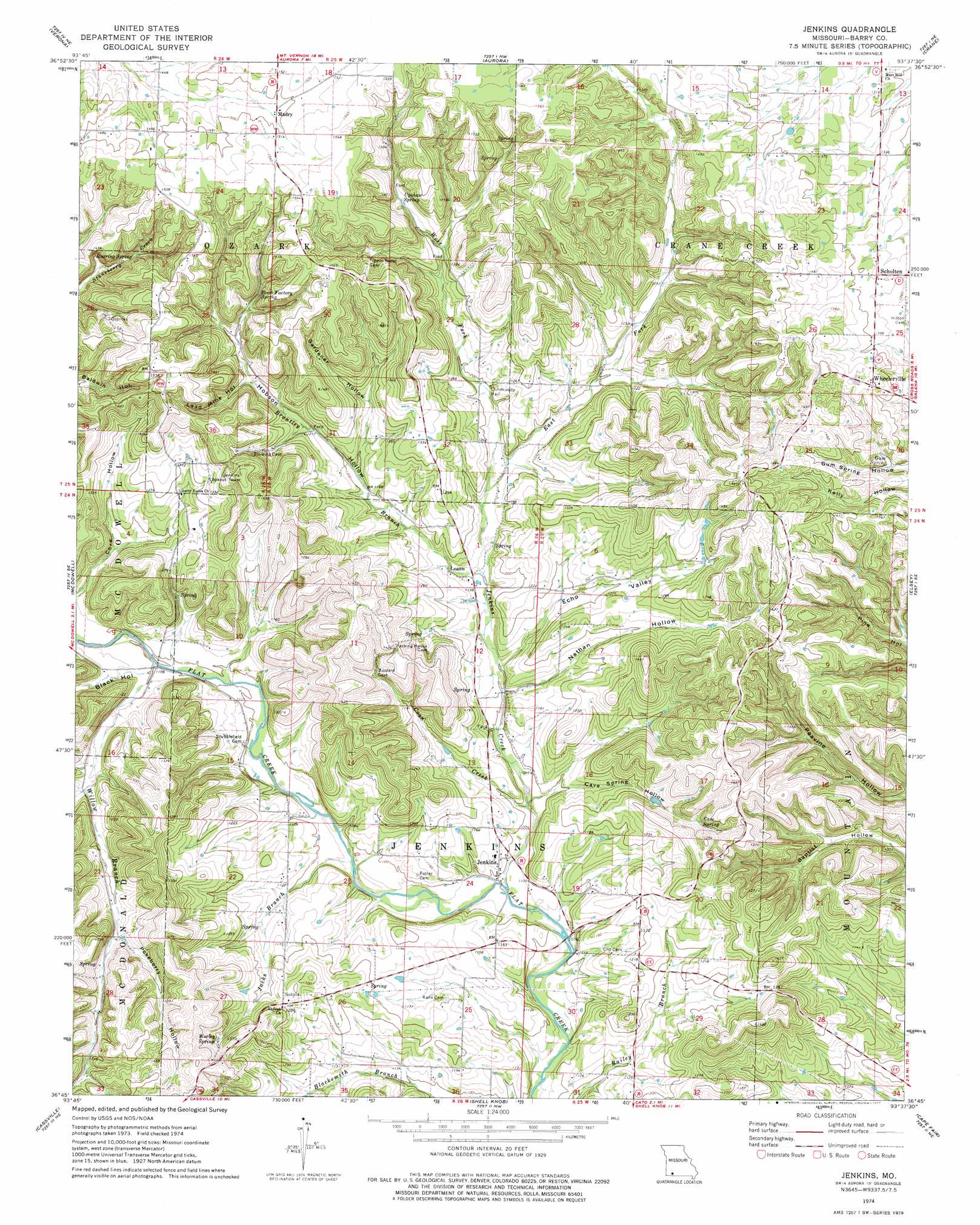
USGS Topo Quad 36093g6 - 1:24,000 scale
| Topo Map Name: | Jenkins |
| USGS Topo Quad ID: | 36093g6 |
| Print Size: | ca. 21 1/4" wide x 27" high |
| Southeast Coordinates: | 36.75° N latitude / 93.625° W longitude |
| Map Center Coordinates: | 36.8125° N latitude / 93.6875° W longitude |
| U.S. State: | MO |
| Filename: | o36093g6.jpg |
| Download Map JPG Image: | Jenkins topo map 1:24,000 scale |
| Map Type: | Topographic |
| Topo Series: | 7.5´ |
| Map Scale: | 1:24,000 |
| Source of Map Images: | United States Geological Survey (USGS) |
| Alternate Map Versions: |
Jenkins MO 1974, updated 1977 Download PDF Buy paper map Jenkins MO 2012 Download PDF Buy paper map Jenkins MO 2015 Download PDF Buy paper map |
1:24,000 Topo Quads surrounding Jenkins
Stotts City |
Mount Vernon |
Chesapeake |
Billings |
Republic |
Monett |
Verona |
Aurora |
Crane |
Hurley |
Purdy |
Mcdowell |
Jenkins |
Elsey |
Galena |
Exeter |
Cassville |
Shell Knob |
Cape Fair |
Reeds Spring |
Seligman |
Eagle Rock |
Golden |
Viola |
Lampe |
> Back to 36093e1 at 1:100,000 scale
> Back to 36092a1 at 1:250,000 scale
> Back to U.S. Topo Maps home
Jenkins topo map: Gazetteer
Jenkins: Populated Places
Jenkins elevation 342m 1122′Leann elevation 346m 1135′
Madry elevation 456m 1496′
Scholten elevation 420m 1377′
Wheelerville elevation 437m 1433′
Jenkins: Post Offices
Roark Post Office (historical) elevation 340m 1115′Jenkins: Springs
Bean Factory Spring elevation 411m 1348′Cave Spring elevation 388m 1272′
Gum Spring elevation 392m 1286′
Roaring Spring elevation 400m 1312′
Upshaw Spring elevation 406m 1332′
Worley Spring elevation 392m 1286′
Jenkins: Streams
Brantley Branch elevation 343m 1125′Coon Creek elevation 329m 1079′
Jacks Branch elevation 329m 1079′
Jenkins Creek elevation 323m 1059′
West Fork Jenkins Creek elevation 351m 1151′
Willow Branch elevation 335m 1099′
Jenkins: Valleys
Black Hollow elevation 341m 1118′Cave Spring Hollow elevation 334m 1095′
Core Hollow elevation 342m 1122′
Echo Valley elevation 339m 1112′
Gardener Hollow elevation 379m 1243′
Hobson Hollow elevation 347m 1138′
Lead Mine Hollow elevation 386m 1266′
Nathan Hollow elevation 335m 1099′
Pokeberry Hollow elevation 376m 1233′
Roark Hollow elevation 352m 1154′
Jenkins digital topo map on disk
Buy this Jenkins topo map showing relief, roads, GPS coordinates and other geographical features, as a high-resolution digital map file on DVD: