Wheeler Topo Map Arkansas
To zoom in, hover over the map of Wheeler
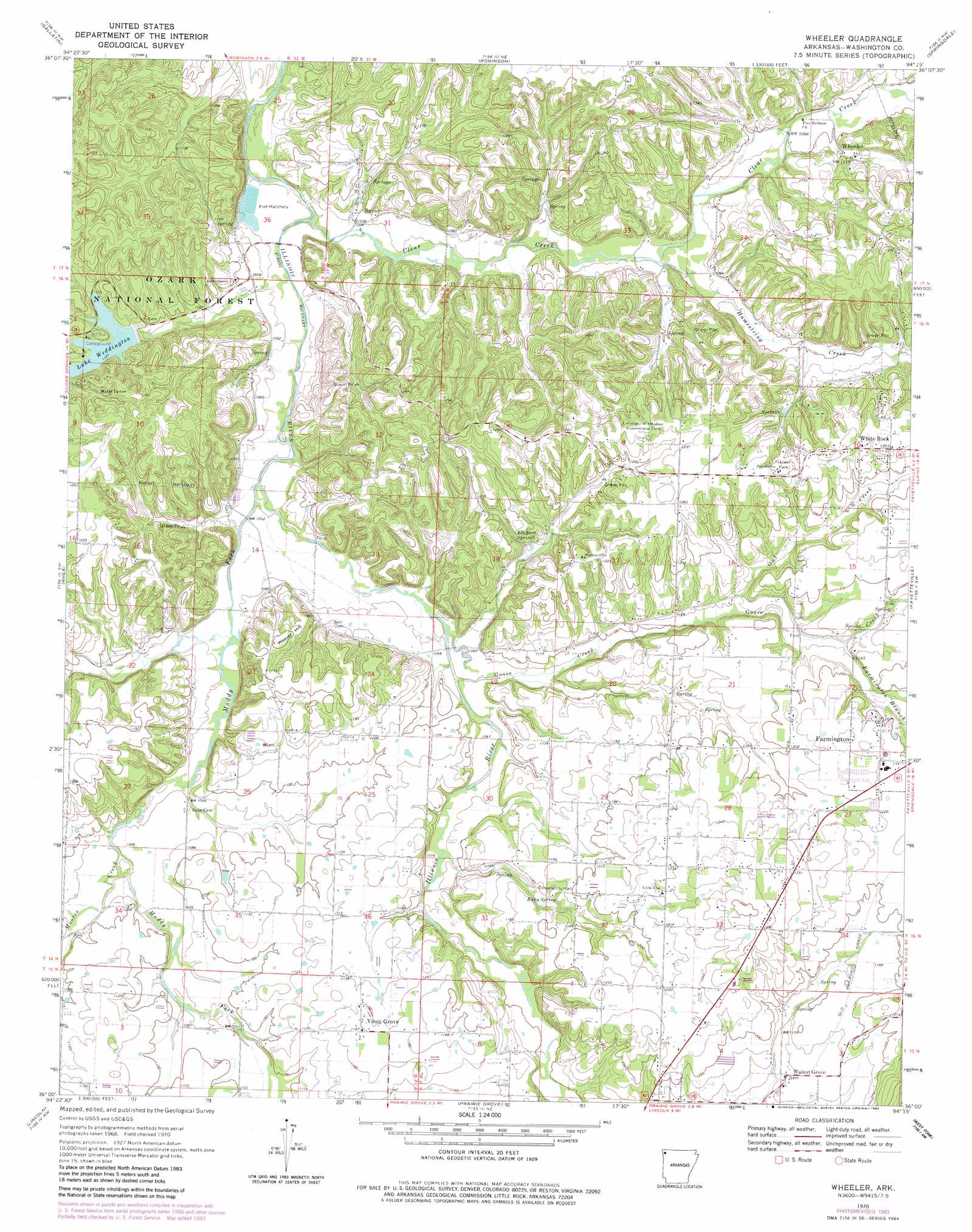
USGS Topo Quad 36094a3 - 1:24,000 scale
| Topo Map Name: | Wheeler |
| USGS Topo Quad ID: | 36094a3 |
| Print Size: | ca. 21 1/4" wide x 27" high |
| Southeast Coordinates: | 36° N latitude / 94.25° W longitude |
| Map Center Coordinates: | 36.0625° N latitude / 94.3125° W longitude |
| U.S. State: | AR |
| Filename: | o36094a3.jpg |
| Download Map JPG Image: | Wheeler topo map 1:24,000 scale |
| Map Type: | Topographic |
| Topo Series: | 7.5´ |
| Map Scale: | 1:24,000 |
| Source of Map Images: | United States Geological Survey (USGS) |
| Alternate Map Versions: |
Wheeler AR 1970, updated 1972 Download PDF Buy paper map Wheeler AR 1970, updated 1978 Download PDF Buy paper map Wheeler AR 1970, updated 1983 Download PDF Buy paper map Wheeler AR 1970, updated 1983 Download PDF Buy paper map Wheeler AR 2011 Download PDF Buy paper map Wheeler AR 2014 Download PDF Buy paper map |
| FStopo: | US Forest Service topo Wheeler is available: Download FStopo PDF Download FStopo TIF |
1:24,000 Topo Quads surrounding Wheeler
Cherokee City |
Gentry |
Centerton |
Bentonville South |
Rogers |
Siloam Springs |
Gallatin |
Robinson |
Springdale |
Sonora |
Watts |
Rhea |
Wheeler |
Fayettville |
Elkins |
Westville |
Lincoln |
Prairie Grove |
West Fork |
Sulphur City |
Stilwell East |
Evansville |
Strickler |
Winslow |
Brentwood |
> Back to 36094a1 at 1:100,000 scale
> Back to 36094a1 at 1:250,000 scale
> Back to U.S. Topo Maps home
Wheeler topo map: Gazetteer
Wheeler: Airports
Wedington Wood Airport elevation 331m 1085′Wheeler: Dams
Lake Wedington Dam elevation 342m 1122′Wheeler: Parks
Lake Wedington Recreation Area elevation 343m 1125′Wheeler: Populated Places
Jabur (historical) elevation 332m 1089′Rickert (historical) elevation 337m 1105′
Savoy elevation 317m 1040′
Starks elevation 382m 1253′
Viney Grove elevation 355m 1164′
Walnut Grove elevation 354m 1161′
Wedington Woods elevation 351m 1151′
Wheeler elevation 342m 1122′
White Rock elevation 381m 1250′
Wheeler: Post Offices
Rickert Post Office (historical) elevation 330m 1082′Viney Grove Post Office (historical) elevation 356m 1167′
Wheeler: Reservoirs
Lake Weddington elevation 342m 1122′Wheeler: Springs
Elkhorn Springs elevation 344m 1128′Ruby Spring elevation 355m 1164′
Wheeler: Streams
Clear Creek elevation 312m 1023′Farmington Branch elevation 346m 1135′
Goose Creek elevation 323m 1059′
Hamestring Creek elevation 324m 1062′
Moores Creek elevation 324m 1062′
Muddy Fork elevation 316m 1036′
Owl Creek elevation 338m 1108′
Wheeler: Summits
Weaver Hill elevation 364m 1194′Wheeler digital topo map on disk
Buy this Wheeler topo map showing relief, roads, GPS coordinates and other geographical features, as a high-resolution digital map file on DVD: