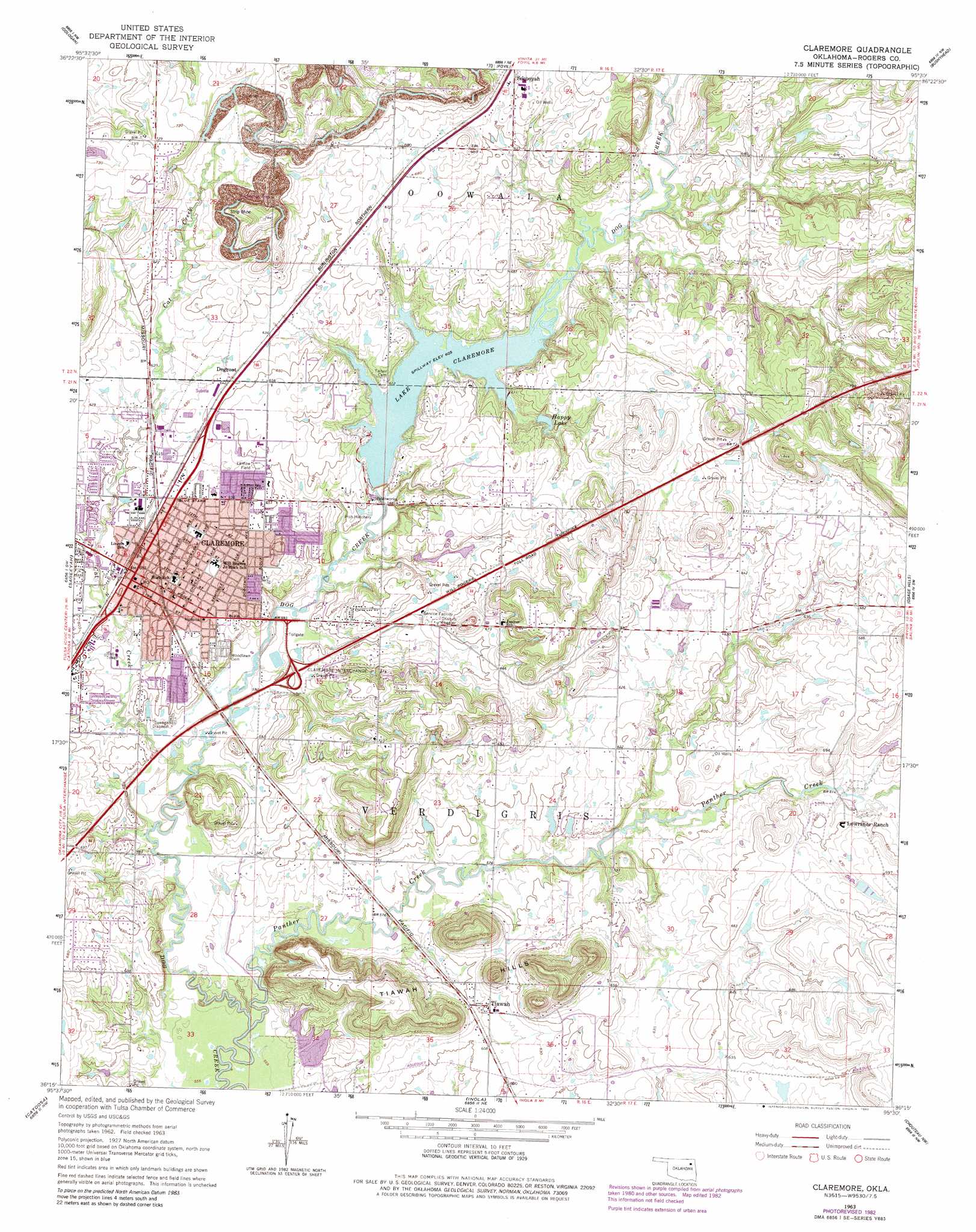
Claremore Topo Map Oklahoma
To zoom in, hover over the map of Claremore
USGS Topo Quad 36095c5 - 1:24,000 scale
| Topo Map Name: | Claremore |
| USGS Topo Quad ID: | 36095c5 |
| Print Size: | ca. 21 1/4" wide x 27" high |
| Southeast Coordinates: | 36.25° N latitude / 95.5° W longitude |
| Map Center Coordinates: | 36.3125° N latitude / 95.5625° W longitude |
| U.S. State: | OK |
| Filename: | o36095c5.jpg |
| Download Map JPG Image: | Claremore topo map 1:24,000 scale |
| Map Type: | Topographic |
| Topo Series: | 7.5´ |
| Map Scale: | 1:24,000 |
| Source of Map Images: | United States Geological Survey (USGS) |
| Alternate Map Versions: |
Claremore OK 1963, updated 1964 Download PDF Buy paper map Claremore OK 1963, updated 1980 Download PDF Buy paper map Claremore OK 1963, updated 1982 Download PDF Buy paper map Claremore OK 2010 Download PDF Buy paper map Claremore OK 2013 Download PDF Buy paper map Claremore OK 2016 Download PDF Buy paper map |
1:24,000 Topo Quads surrounding Claremore
Bartlesville Se |
Talala |
Winganon |
Chelsea |
White Oak |
Collinsville Ne |
Oologah |
Foyil |
Bushyhead |
Adair |
Collinsville |
Sageeyah |
Claremore |
Osage Hills |
Pryor |
Mingo |
Catoosa |
Inola |
Choteau Nw |
Chouteau |
Broken Arrow |
Oneta |
Catoosa Se |
Neodesha |
Rocky Point |
> Back to 36095a1 at 1:100,000 scale
> Back to 36094a1 at 1:250,000 scale
> Back to U.S. Topo Maps home
Claremore topo map: Gazetteer
Claremore: Airports
Claremore Regional Hospital Heliport elevation 192m 629′Claremore: Crossings
Claremore Interchange elevation 187m 613′Claremore: Dams
Claremore Dam elevation 177m 580′Happy Lake Dam elevation 195m 639′
O L Fisher Pond Dam elevation 217m 711′
Petersons Lake Dam elevation 188m 616′
Claremore: Populated Places
Claremore elevation 182m 597′Degroat elevation 194m 636′
Justice elevation 207m 679′
Sequoyah elevation 203m 666′
Tiawah elevation 188m 616′
Claremore: Ranges
Tiawah Hills elevation 241m 790′Claremore: Reservoirs
Claremore Lake elevation 177m 580′Happy Lake elevation 187m 613′
Lake Claremore elevation 182m 597′
O L Fisher Pond elevation 217m 711′
Petersons Lake elevation 188m 616′
Claremore: Streams
Cat Creek elevation 170m 557′Panther Creek elevation 168m 551′
Claremore digital topo map on disk
Buy this Claremore topo map showing relief, roads, GPS coordinates and other geographical features, as a high-resolution digital map file on DVD: