Sand Springs Topo Map Oklahoma
To zoom in, hover over the map of Sand Springs
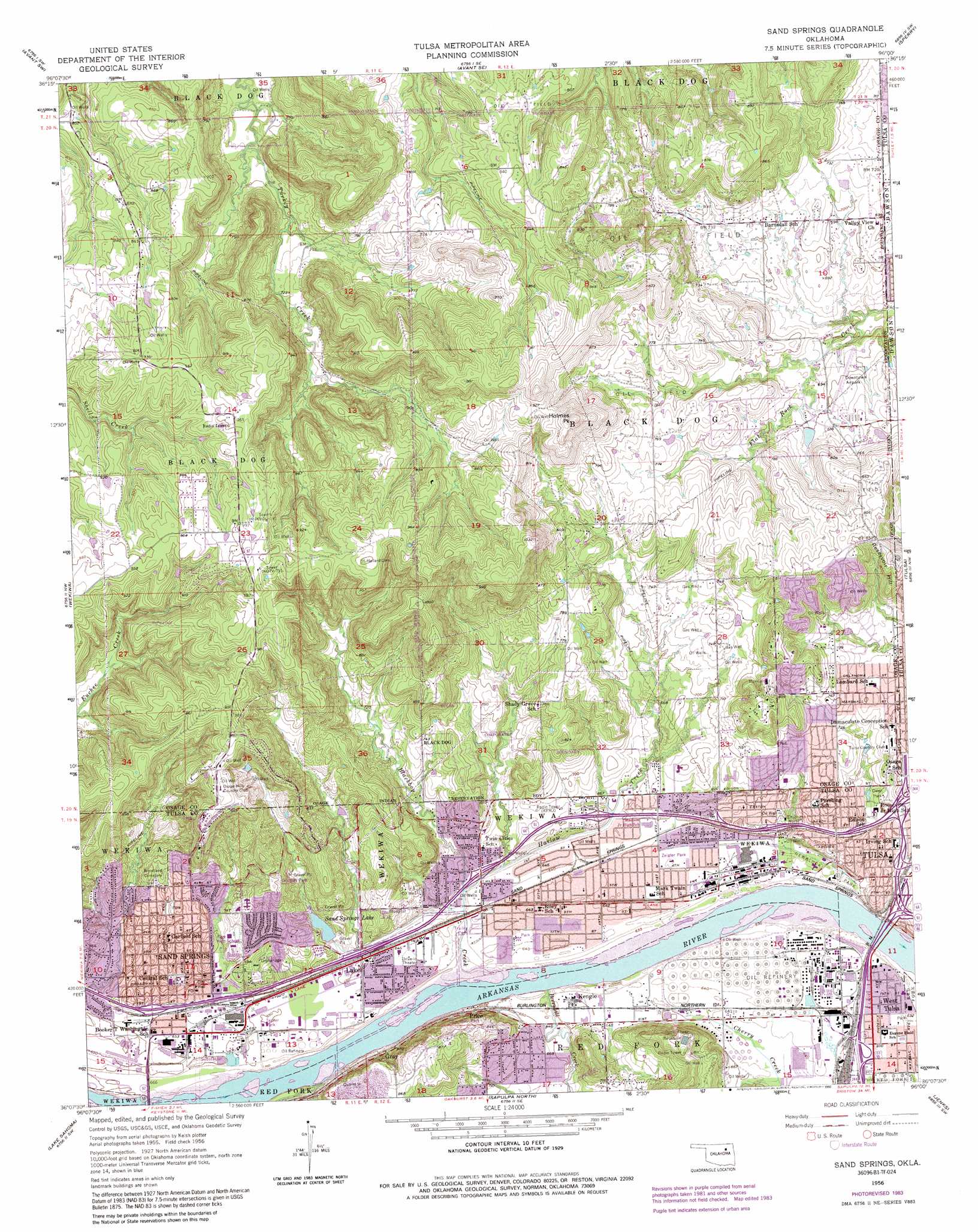
USGS Topo Quad 36096b1 - 1:24,000 scale
| Topo Map Name: | Sand Springs |
| USGS Topo Quad ID: | 36096b1 |
| Print Size: | ca. 21 1/4" wide x 27" high |
| Southeast Coordinates: | 36.125° N latitude / 96° W longitude |
| Map Center Coordinates: | 36.1875° N latitude / 96.0625° W longitude |
| U.S. State: | OK |
| Filename: | o36096b1.jpg |
| Download Map JPG Image: | Sand Springs topo map 1:24,000 scale |
| Map Type: | Topographic |
| Topo Series: | 7.5´ |
| Map Scale: | 1:24,000 |
| Source of Map Images: | United States Geological Survey (USGS) |
| Alternate Map Versions: |
Sand Springs OK 1956, updated 1957 Download PDF Buy paper map Sand Springs OK 1956, updated 1965 Download PDF Buy paper map Sand Springs OK 1956, updated 1968 Download PDF Buy paper map Sand Springs OK 1956, updated 1975 Download PDF Buy paper map Sand Springs OK 1956, updated 1983 Download PDF Buy paper map Sand Springs OK 1956, updated 1992 Download PDF Buy paper map Sand Springs OK 2010 Download PDF Buy paper map Sand Springs OK 2012 Download PDF Buy paper map Sand Springs OK 2016 Download PDF Buy paper map |
1:24,000 Topo Quads surrounding Sand Springs
Hominy Ne |
Avant Nw |
Avant |
Vera |
Collinsville Ne |
New Prue |
Avant Sw |
Avant Se |
Sperry |
Collinsville |
Keystone Dam |
Wekiwa |
Sand Springs |
Tulsa |
Mingo |
Mannford Se |
Lake Sahoma |
Sapulpa North |
Jenks |
Broken Arrow |
Heyburn Reservoir |
Kellyville |
Sapulpa South |
Bixby |
Leonard |
> Back to 36096a1 at 1:100,000 scale
> Back to 36096a1 at 1:250,000 scale
> Back to U.S. Topo Maps home
Sand Springs topo map: Gazetteer
Sand Springs: Airports
Downtown Airpark elevation 213m 698′Sand Springs: Dams
Oknoname 143001 Dam elevation 237m 777′Sand Springs Dam elevation 209m 685′
Theisen Dam elevation 215m 705′
Sand Springs: Parks
Chandler Park elevation 257m 843′Douglas Park elevation 259m 849′
Newblock Park elevation 192m 629′
Owen Park elevation 208m 682′
Zeigler Park elevation 195m 639′
Sand Springs: Populated Places
Gray elevation 206m 675′Kengle elevation 196m 643′
Lake elevation 197m 646′
Price elevation 197m 646′
Sand Springs elevation 206m 675′
West Tulsa elevation 193m 633′
Sand Springs: Reservoirs
Oknoname 143001 Reservoir elevation 237m 777′Sand Springs Lake elevation 209m 685′
Theisen Lake elevation 215m 705′
Sand Springs: Streams
Berryhill Creek elevation 191m 626′Bigheart Creek elevation 191m 626′
Harlow Creek elevation 194m 636′
Sand Springs: Summits
Holmes Peak elevation 314m 1030′Reservoir Hill elevation 269m 882′
Sand Springs digital topo map on disk
Buy this Sand Springs topo map showing relief, roads, GPS coordinates and other geographical features, as a high-resolution digital map file on DVD: