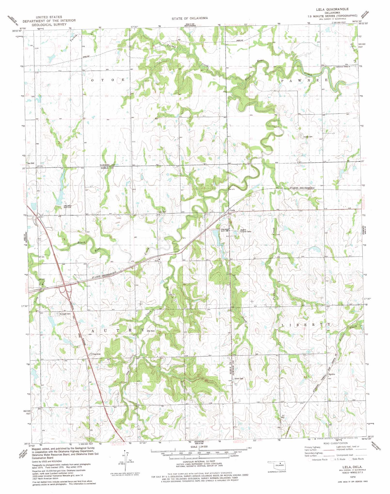
Lela Topo Map Oklahoma
To zoom in, hover over the map of Lela
USGS Topo Quad 36096c8 - 1:24,000 scale
| Topo Map Name: | Lela |
| USGS Topo Quad ID: | 36096c8 |
| Print Size: | ca. 21 1/4" wide x 27" high |
| Southeast Coordinates: | 36.25° N latitude / 96.875° W longitude |
| Map Center Coordinates: | 36.3125° N latitude / 96.9375° W longitude |
| U.S. State: | OK |
| Filename: | o36096c8.jpg |
| Download Map JPG Image: | Lela topo map 1:24,000 scale |
| Map Type: | Topographic |
| Topo Series: | 7.5´ |
| Map Scale: | 1:24,000 |
| Source of Map Images: | United States Geological Survey (USGS) |
| Alternate Map Versions: |
Lela OK 1978, updated 1978 Download PDF Buy paper map Lela OK 2009 Download PDF Buy paper map Lela OK 2012 Download PDF Buy paper map Lela OK 2016 Download PDF Buy paper map |
1:24,000 Topo Quads surrounding Lela
Marland |
Ponca City Se |
Prettyhair Creek |
Doga Creek |
Fairfax |
Red Rock |
Morrison Ne |
Watchorn |
Masham |
Skedee |
Black Bear |
Morrison |
Lela |
Pawnee |
Casey |
Lake Carl Blackwell |
Stillwater North |
Glencoe |
West Point |
Maramec |
Stillwater Sw |
Stillwater South |
Ripley |
Twin Mounds |
Yale |
> Back to 36096a1 at 1:100,000 scale
> Back to 36096a1 at 1:250,000 scale
> Back to U.S. Topo Maps home
Lela topo map: Gazetteer
Lela: Dams
Long Branch Creek Site 11 Dam elevation 282m 925′Long Branch Watershed Site 11 Dam elevation 282m 925′
Lower Black Bear Creek Site 11 Dam elevation 274m 898′
Lower Black Bear Creek Site 14 Dam elevation 275m 902′
Lower Black Bear Creek Site 6 Dam elevation 266m 872′
Oknoname 117003 Dam elevation 303m 994′
Oknoname 117004 Dam elevation 278m 912′
Lela: Populated Places
Lela elevation 268m 879′Rambo elevation 314m 1030′
Lela: Reservoirs
Long Branch Creek Site 11 Reservoir elevation 282m 925′Long Branch Watershed Site 11 Reservoir elevation 282m 925′
Lower Black Bear Creek Site 11 Reservoir elevation 274m 898′
Lower Black Bear Creek Site 14 Reservoir elevation 275m 902′
Lower Black Bear Creek Site 6 Reservoir elevation 266m 872′
Oknoname 117003 Reservoir elevation 303m 994′
Oknoname 117004 Reservoir elevation 278m 912′
Lela: Streams
Lion Creek elevation 260m 853′Long Branch elevation 268m 879′
Oak Creek elevation 263m 862′
Panther Creek elevation 258m 846′
Lela digital topo map on disk
Buy this Lela topo map showing relief, roads, GPS coordinates and other geographical features, as a high-resolution digital map file on DVD: