Morrison Topo Map Oklahoma
To zoom in, hover over the map of Morrison
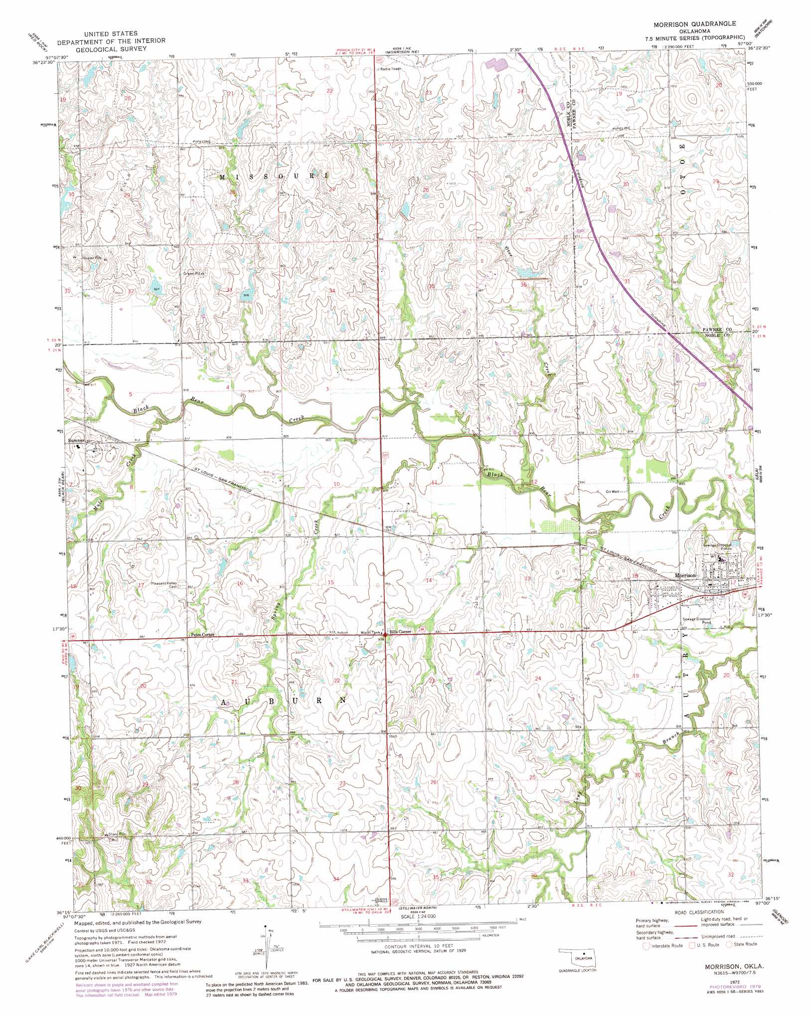
USGS Topo Quad 36097c1 - 1:24,000 scale
| Topo Map Name: | Morrison |
| USGS Topo Quad ID: | 36097c1 |
| Print Size: | ca. 21 1/4" wide x 27" high |
| Southeast Coordinates: | 36.25° N latitude / 97° W longitude |
| Map Center Coordinates: | 36.3125° N latitude / 97.0625° W longitude |
| U.S. State: | OK |
| Filename: | o36097c1.jpg |
| Download Map JPG Image: | Morrison topo map 1:24,000 scale |
| Map Type: | Topographic |
| Topo Series: | 7.5´ |
| Map Scale: | 1:24,000 |
| Source of Map Images: | United States Geological Survey (USGS) |
| Alternate Map Versions: |
Morrison OK 1972, updated 1974 Download PDF Buy paper map Morrison OK 1972, updated 1979 Download PDF Buy paper map Morrison OK 1972, updated 1984 Download PDF Buy paper map Morrison OK 2009 Download PDF Buy paper map Morrison OK 2012 Download PDF Buy paper map Morrison OK 2016 Download PDF Buy paper map |
1:24,000 Topo Quads surrounding Morrison
Tonkawa Se |
Marland |
Ponca City Se |
Prettyhair Creek |
Doga Creek |
Ceres |
Red Rock |
Morrison Ne |
Watchorn |
Masham |
Perry |
Black Bear |
Morrison |
Lela |
Pawnee |
Orlando East |
Lake Carl Blackwell |
Stillwater North |
Glencoe |
West Point |
Clear Creek |
Stillwater Sw |
Stillwater South |
Ripley |
Twin Mounds |
> Back to 36097a1 at 1:100,000 scale
> Back to 36096a1 at 1:250,000 scale
> Back to U.S. Topo Maps home
Morrison topo map: Gazetteer
Morrison: Dams
Upper Black Bear Creek Site 2 Dam elevation 288m 944′Upper Black Bear Creek Site 5 Dam elevation 290m 951′
Upper Black Bear Creek Site 6 Dam elevation 282m 925′
Upper Black Bear Creek Site 7 Dam elevation 284m 931′
Upper Black Bear Creek Site 75 Dam elevation 283m 928′
Morrison: Populated Places
Bills Corner elevation 285m 935′Morrison elevation 286m 938′
Petes Corner elevation 294m 964′
Sumner elevation 291m 954′
Morrison: Reservoirs
Upper Black Bear Creek Site 2 Reservoir elevation 288m 944′Upper Black Bear Creek Site 5 Reservoir elevation 290m 951′
Upper Black Bear Creek Site 6 Reservoir elevation 282m 925′
Upper Black Bear Creek Site 7 Reservoir elevation 284m 931′
Upper Black Bear Creek Site 75 Reservoir elevation 283m 928′
Morrison: Streams
Mule Creek elevation 271m 889′Otoe Creek elevation 268m 879′
Spring Creek elevation 271m 889′
Morrison digital topo map on disk
Buy this Morrison topo map showing relief, roads, GPS coordinates and other geographical features, as a high-resolution digital map file on DVD: