Saltpeter Mountain Topo Map New Mexico
To zoom in, hover over the map of Saltpeter Mountain
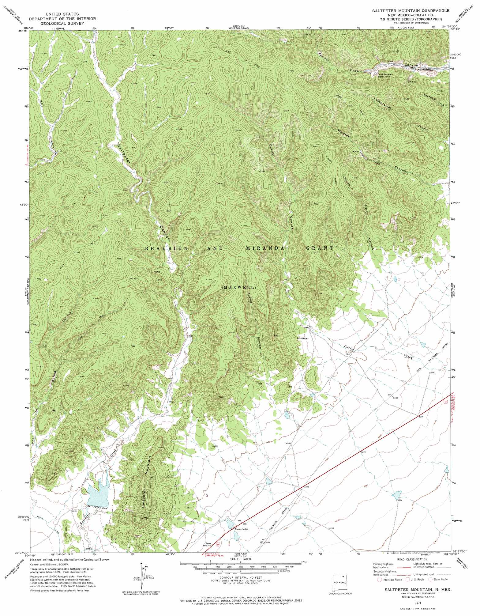
USGS Topo Quad 36104f6 - 1:24,000 scale
| Topo Map Name: | Saltpeter Mountain |
| USGS Topo Quad ID: | 36104f6 |
| Print Size: | ca. 21 1/4" wide x 27" high |
| Southeast Coordinates: | 36.625° N latitude / 104.625° W longitude |
| Map Center Coordinates: | 36.6875° N latitude / 104.6875° W longitude |
| U.S. State: | NM |
| Filename: | o36104f6.jpg |
| Download Map JPG Image: | Saltpeter Mountain topo map 1:24,000 scale |
| Map Type: | Topographic |
| Topo Series: | 7.5´ |
| Map Scale: | 1:24,000 |
| Source of Map Images: | United States Geological Survey (USGS) |
| Alternate Map Versions: |
Saltpeter Mountain NM 1971, updated 1974 Download PDF Buy paper map Saltpeter Mountain NM 2010 Download PDF Buy paper map Saltpeter Mountain NM 2013 Download PDF Buy paper map |
1:24,000 Topo Quads surrounding Saltpeter Mountain
Casa Grande |
Caliente Canyon North |
Mcwilliams Canyon |
Tin Pan Canyon |
Raton |
Casa Grande Sw |
Caliente Canyon South |
Curtis Camp |
Red River Peak |
Clifton House |
House Canyon |
Dawson |
Saltpeter Mountain |
Koehler |
Eagle Tail Mountain |
Cimarron |
Cimarron Se |
Colfax |
Maxwell |
Loco Arroyo |
Coyote Mesa |
Miami Ne |
Springer Lake |
French |
Abbott Nw |
> Back to 36104e1 at 1:100,000 scale
> Back to 36104a1 at 1:250,000 scale
> Back to U.S. Topo Maps home
Saltpeter Mountain topo map: Gazetteer
Saltpeter Mountain: Dams
Saltpeter Creek Site 1a Dam elevation 1944m 6377′Saltpeter Dam elevation 1944m 6377′
Saltpeter Mountain: Mines
Koehler Mine elevation 2087m 6847′Koehler Number One elevation 2066m 6778′
Koehler Number Three Mine elevation 2083m 6833′
Koehler Number Two Mine elevation 2083m 6833′
Saltpeter Mountain: Reservoirs
Twin Lakes elevation 1915m 6282′Saltpeter Mountain: Summits
Saltpeter Mountain elevation 2151m 7057′Saltpeter Mountain: Valleys
Curtis Canyon elevation 1969m 6459′North Curtis Canyon elevation 1999m 6558′
Saltpeter Canyon elevation 1929m 6328′
Turkey Canyon elevation 1980m 6496′
Waldron Canyon elevation 1972m 6469′
Saltpeter Mountain digital topo map on disk
Buy this Saltpeter Mountain topo map showing relief, roads, GPS coordinates and other geographical features, as a high-resolution digital map file on DVD: