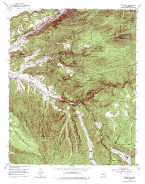
Trampas Topo Map New Mexico
To zoom in, hover over the map of Trampas
USGS Topo Quad 36105b7 - 1:24,000 scale
| Topo Map Name: | Trampas |
| USGS Topo Quad ID: | 36105b7 |
| Print Size: | ca. 21 1/4" wide x 27" high |
| Southeast Coordinates: | 36.125° N latitude / 105.75° W longitude |
| Map Center Coordinates: | 36.1875° N latitude / 105.8125° W longitude |
| U.S. State: | NM |
| Filename: | o36105b7.jpg |
| Download Map JPG Image: | Trampas topo map 1:24,000 scale |
| Map Type: | Topographic |
| Topo Series: | 7.5´ |
| Map Scale: | 1:24,000 |
| Source of Map Images: | United States Geological Survey (USGS) |
| Alternate Map Versions: |
Trampas NM 1953, updated 1955 Download PDF Buy paper map Trampas NM 1953, updated 1965 Download PDF Buy paper map Trampas NM 1953, updated 1975 Download PDF Buy paper map Trampas NM 1995, updated 1997 Download PDF Buy paper map Trampas NM 2011 Download PDF Buy paper map Trampas NM 2013 Download PDF Buy paper map |
| FStopo: | US Forest Service topo Trampas is available: Download FStopo PDF Download FStopo TIF |
1:24,000 Topo Quads surrounding Trampas
> Back to 36105a1 at 1:100,000 scale
> Back to 36104a1 at 1:250,000 scale
> Back to U.S. Topo Maps home
Trampas topo map: Gazetteer
Trampas: Bridges
Glen Woody Bridge elevation 1808m 5931′Trampas: Canals
El Llano Ditch elevation 1859m 6099′Trampas: Mines
Champion Mine elevation 2296m 7532′Champion Mine elevation 2299m 7542′
Dulfney Mine elevation 2203m 7227′
Glenwoody Camp elevation 1809m 5935′
Harding Mine elevation 2255m 7398′
Harding Pegmatite elevation 2264m 7427′
Oro Grande Company of Pennsylvania elevation 1906m 6253′
Owens-Roybal Group elevation 2195m 7201′
The Tungsten Mine elevation 2469m 8100′
Theodore Glass Property elevation 2243m 7358′
Tungsten Mine elevation 2477m 8126′
Wilson Prospect elevation 2360m 7742′
Trampas: Parks
Las Trampas Historical Marker elevation 2250m 7381′Trampas: Populated Places
Apodaca elevation 1866m 6122′Cañoncito elevation 1902m 6240′
La Cuestecita elevation 2103m 6899′
Montecito elevation 1883m 6177′
Rinconada elevation 1800m 5905′
Trampas elevation 2263m 7424′
Vallecito elevation 2153m 7063′
Trampas: Post Offices
Rinconada Post Office (historical) elevation 1806m 5925′Trampas Post Office elevation 2263m 7424′
Trampas: Rapids
Big Rock Rapid elevation 1806m 5925′Souse Hole Rapid elevation 1797m 5895′
Trampas: Reservoirs
Cejeta East Trick Tank elevation 2293m 7522′Cejeta North Trick Tank elevation 2235m 7332′
Cejeta West Trick Tank elevation 2241m 7352′
Trampas: Ridges
La Sierrita elevation 2643m 8671′Trampas: Streams
Arroyo del Plomo elevation 2012m 6601′Cañada de Apodaca elevation 1852m 6076′
Cañada de Barro elevation 2165m 7103′
Cañada de la Madera elevation 2246m 7368′
Cañada de la Marias elevation 2168m 7112′
Cañada de la Orilla elevation 2016m 6614′
Cañada de Lorenzo elevation 2019m 6624′
Cañada de Montecito elevation 1857m 6092′
Cañada de Ojo Sarco elevation 1902m 6240′
Cañada de Oso elevation 1987m 6519′
Cañada de Piedra Lumbre elevation 1876m 6154′
Cañada del Agua elevation 2064m 6771′
Cañada del Arrastradero elevation 2264m 7427′
Cañada los Alamos elevation 2216m 7270′
Canada los Pino Reales elevation 1887m 6190′
Chamizal Creek elevation 2156m 7073′
Rio de las Trampas elevation 2015m 6610′
Trampas: Summits
Cerro Alto elevation 2365m 7759′Cerro Colorado elevation 2355m 7726′
Cerro de Arriba elevation 1965m 6446′
Cerro de la Cruz elevation 2350m 7709′
Cerro de la Rana elevation 2312m 7585′
Cerro de las Marquenas elevation 2330m 7644′
Cerro de los Arboles elevation 2377m 7798′
Cerro del Abrevadero elevation 2164m 7099′
Cerro Puntiagudo elevation 2284m 7493′
Copper Hill elevation 2383m 7818′
Trampas: Wells
HC 50552 Water Well elevation 1797m 5895′HC-56935 Water Well elevation 1855m 6085′
HC-69095 Water Well elevation 1913m 6276′
RG-19538 Water Well elevation 1877m 6158′
RG-23197 Water Well elevation 1920m 6299′
RG-25231 Water Well elevation 1897m 6223′
RG-25617 Water Well elevation 1862m 6108′
RG-25752 Water Well elevation 1920m 6299′
RG-5488 Water Well elevation 1862m 6108′
RG-5684 Water Well elevation 1853m 6079′
Trampas digital topo map on disk
Buy this Trampas topo map showing relief, roads, GPS coordinates and other geographical features, as a high-resolution digital map file on DVD:


