White Peak Topo Map New Mexico
To zoom in, hover over the map of White Peak
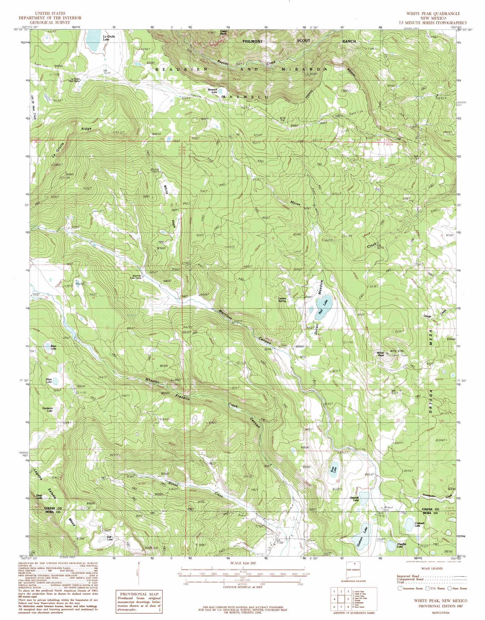
USGS Topo Quad 36105c1 - 1:24,000 scale
| Topo Map Name: | White Peak |
| USGS Topo Quad ID: | 36105c1 |
| Print Size: | ca. 21 1/4" wide x 27" high |
| Southeast Coordinates: | 36.25° N latitude / 105° W longitude |
| Map Center Coordinates: | 36.3125° N latitude / 105.0625° W longitude |
| U.S. State: | NM |
| Filename: | o36105c1.jpg |
| Download Map JPG Image: | White Peak topo map 1:24,000 scale |
| Map Type: | Topographic |
| Topo Series: | 7.5´ |
| Map Scale: | 1:24,000 |
| Source of Map Images: | United States Geological Survey (USGS) |
| Alternate Map Versions: |
White Peak NM 1987, updated 1987 Download PDF Buy paper map White Peak NM 1994, updated 1998 Download PDF Buy paper map White Peak NM 2010 Download PDF Buy paper map White Peak NM 2013 Download PDF Buy paper map White Peak NM 2017 Download PDF Buy paper map |
1:24,000 Topo Quads surrounding White Peak
Eagle Nest |
Touch-Me-Not Mountain |
Ute Park |
Cimarron |
Cimarron Se |
Palo Flechado Pass |
Garcia Peak |
Tooth Of Time |
Coyote Mesa |
Miami Ne |
Osha Mountain |
Agua Fria Peak |
White Peak |
Rayado |
Miami |
Chacon |
Guadalupita |
Ocate |
Mora Ranch |
Charette Lake |
Comanche Peak |
Lucero |
Ojo Feliz |
Cerro Negro |
La Chata Crater |
> Back to 36105a1 at 1:100,000 scale
> Back to 36104a1 at 1:250,000 scale
> Back to U.S. Topo Maps home
White Peak topo map: Gazetteer
White Peak: Areas
Duran Meadow elevation 2538m 8326′White Peak: Lakes
Bear Lake elevation 2806m 9206′Beaver Ponds elevation 2739m 8986′
Caldwell Lake elevation 2434m 7985′
Deep Lake elevation 2831m 9288′
Gardenia Lake elevation 2835m 9301′
Graham Lake elevation 2429m 7969′
La Grulla Lake elevation 2799m 9183′
Mare Lake elevation 2817m 9242′
Rimrock Lake elevation 2802m 9192′
Rose Lake elevation 2446m 8024′
Salt Lake elevation 2719m 8920′
Sawmill Lake elevation 2434m 7985′
Sheaffer Lake elevation 2422m 7946′
White Peak: Ridges
La Grulla Ridge elevation 3047m 9996′White Peak: Springs
Lucero Spring elevation 2574m 8444′White Peak: Streams
Bonita Creek elevation 2355m 7726′White Peak: Summits
Crater Peak elevation 2823m 9261′Ortega Mesa elevation 2668m 8753′
Rivera Mesa elevation 2447m 8028′
White Peak elevation 2668m 8753′
White Peak: Valleys
White Vega elevation 2576m 8451′White Peak digital topo map on disk
Buy this White Peak topo map showing relief, roads, GPS coordinates and other geographical features, as a high-resolution digital map file on DVD: