Eagle Nest Topo Map New Mexico
To zoom in, hover over the map of Eagle Nest
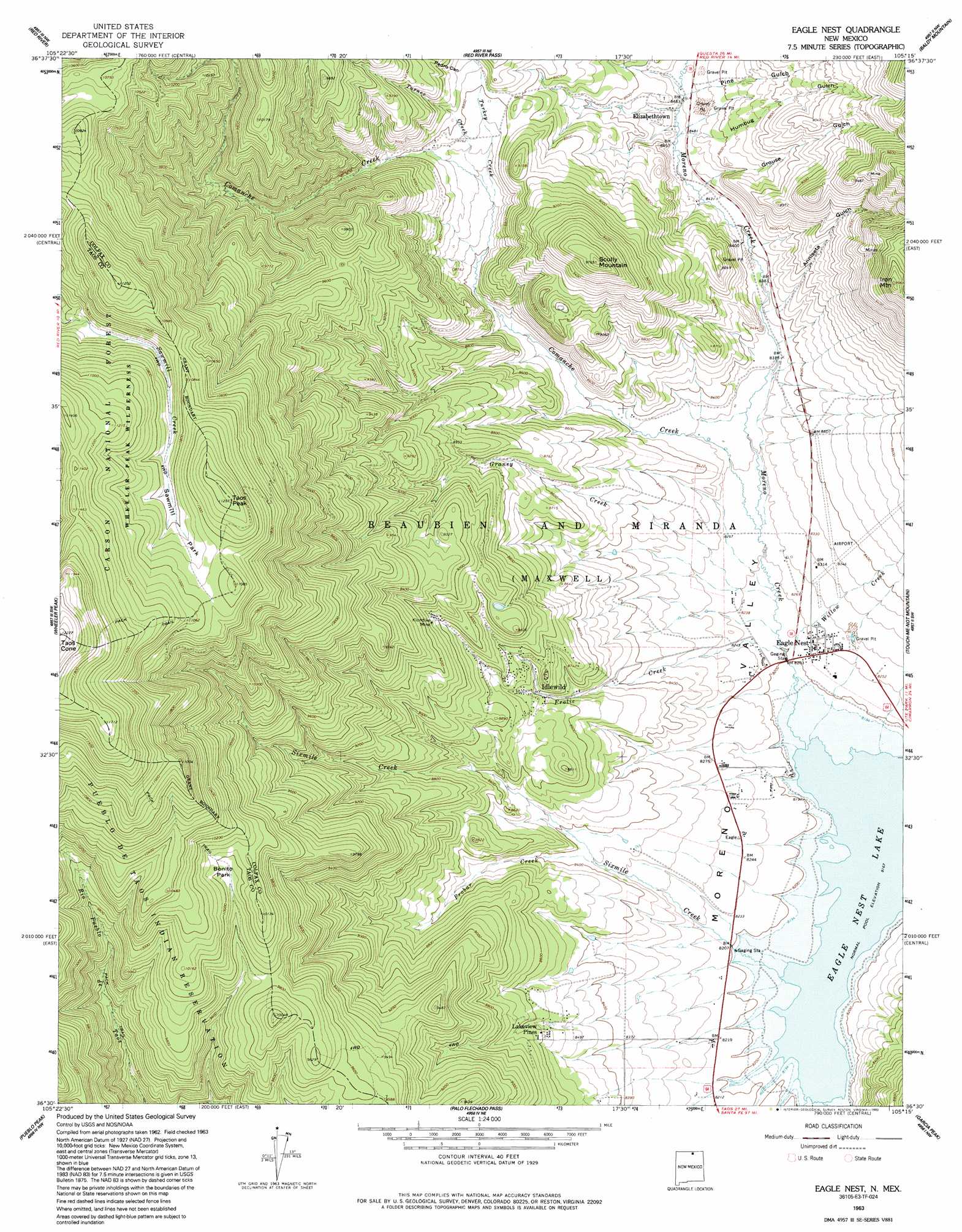
USGS Topo Quad 36105e3 - 1:24,000 scale
| Topo Map Name: | Eagle Nest |
| USGS Topo Quad ID: | 36105e3 |
| Print Size: | ca. 21 1/4" wide x 27" high |
| Southeast Coordinates: | 36.5° N latitude / 105.25° W longitude |
| Map Center Coordinates: | 36.5625° N latitude / 105.3125° W longitude |
| U.S. State: | NM |
| Filename: | o36105e3.jpg |
| Download Map JPG Image: | Eagle Nest topo map 1:24,000 scale |
| Map Type: | Topographic |
| Topo Series: | 7.5´ |
| Map Scale: | 1:24,000 |
| Source of Map Images: | United States Geological Survey (USGS) |
| Alternate Map Versions: |
Eagle Nest NM 1963, updated 1967 Download PDF Buy paper map Eagle Nest NM 1963, updated 1975 Download PDF Buy paper map Eagle Nest NM 1963, updated 1993 Download PDF Buy paper map Eagle Nest NM 1995, updated 1997 Download PDF Buy paper map Eagle Nest NM 2011 Download PDF Buy paper map Eagle Nest NM 2013 Download PDF Buy paper map |
| FStopo: | US Forest Service topo Eagle Nest is available: Download FStopo PDF Download FStopo TIF |
1:24,000 Topo Quads surrounding Eagle Nest
Cerro |
Latir Peak |
Comanche Point |
Ash Mountain |
Van Bremmer Park |
Questa |
Red River |
Red River Pass |
Baldy Mountain |
Abreu Canyon |
Arroyo Seco |
Wheeler Peak |
Eagle Nest |
Touch-Me-Not Mountain |
Ute Park |
Taos |
Pueblo Peak |
Palo Flechado Pass |
Garcia Peak |
Tooth Of Time |
Ranchos De Taos |
Shady Brook |
Osha Mountain |
Agua Fria Peak |
White Peak |
> Back to 36105e1 at 1:100,000 scale
> Back to 36104a1 at 1:250,000 scale
> Back to U.S. Topo Maps home
Eagle Nest topo map: Gazetteer
Eagle Nest: Airports
Eagle Nest Landing Strip elevation 2613m 8572′Eagle Nest: Areas
Moreno Valley elevation 2515m 8251′Eagle Nest: Flats
Bonito Park elevation 3030m 9940′Sawmill Park elevation 3293m 10803′
Eagle Nest: Mines
Abraham Lincoln elevation 2963m 9721′Black Cat Mine elevation 2868m 9409′
Black Hat Mine elevation 2868m 9409′
Blue Bandana Reservation elevation 2640m 8661′
Confidence elevation 2836m 9304′
Convention Anex Number One Mine elevation 2868m 9409′
Denver elevation 2860m 9383′
Denver-Climax elevation 2725m 8940′
Dorn elevation 2838m 9311′
Empire elevation 2824m 9265′
Galena elevation 2880m 9448′
Gertrude elevation 2882m 9455′
Gold Plume Mine elevation 2868m 9409′
Imperial Number Two Mine elevation 2868m 9409′
Iron Mountain Prospect elevation 2846m 9337′
Justice elevation 2849m 9347′
Klondike Mine elevation 2765m 9071′
Klondyke elevation 2603m 8540′
Log Cabin Number Two Mine elevation 2868m 9409′
Lucia elevation 2967m 9734′
Moreno Centennial elevation 2796m 9173′
Oro Dredging Company Claims elevation 2569m 8428′
Pack Rat Mine elevation 2868m 9409′
Pay Ore elevation 3054m 10019′
Red Bandana Group elevation 2766m 9074′
Sheridan elevation 2799m 9183′
Tomboy elevation 2917m 9570′
Eagle Nest: Parks
D A V Vietnam Veterans National Memorial Historical Marker elevation 2511m 8238′Elizabethtown Historical Marker elevation 2585m 8480′
Eagle Nest: Populated Places
Eagle Nest elevation 2511m 8238′Elizabethtown elevation 2585m 8480′
Idlewild elevation 2626m 8615′
Lakeview Pines elevation 2620m 8595′
Val Verde Ski Area elevation 2836m 9304′
Eagle Nest: Post Offices
Eagle Nest Post Office elevation 2511m 8238′Elizabethtown Post Office (historical) elevation 2585m 8480′
Eagle Nest: Streams
Cieneguilla Creek elevation 2491m 8172′Comanche Creek elevation 2515m 8251′
Frolic Creek elevation 2501m 8205′
Graney Creek elevation 2510m 8234′
Moreno Creek elevation 2491m 8172′
Pine Creek elevation 2589m 8494′
Probar Creek elevation 2548m 8359′
Sixmile Creek elevation 2500m 8202′
Turkey Creek elevation 2637m 8651′
Turner Creek elevation 2640m 8661′
Willow Creek elevation 2500m 8202′
Eagle Nest: Summits
Iron Mountain elevation 3031m 9944′Scully Mountain elevation 2982m 9783′
Taos Peak elevation 3430m 11253′
Eagle Nest: Valleys
Anniseta Gulch elevation 2560m 8398′Grouse Gulch elevation 2576m 8451′
Humbug Gulch elevation 2598m 8523′
Pedro Canyon elevation 2700m 8858′
Eagle Nest digital topo map on disk
Buy this Eagle Nest topo map showing relief, roads, GPS coordinates and other geographical features, as a high-resolution digital map file on DVD: