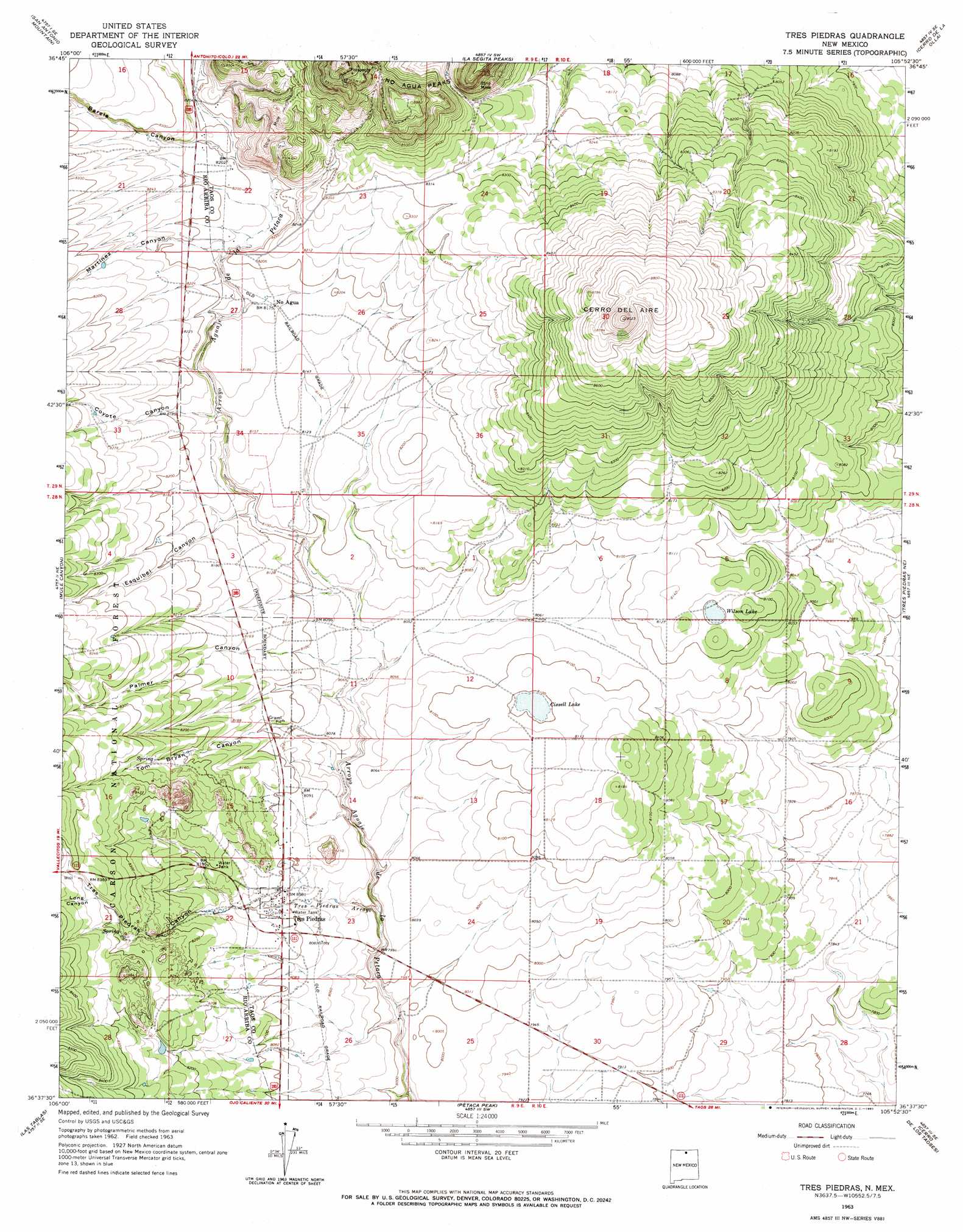
Tres Piedras Topo Map New Mexico
To zoom in, hover over the map of Tres Piedras
USGS Topo Quad 36105f8 - 1:24,000 scale
| Topo Map Name: | Tres Piedras |
| USGS Topo Quad ID: | 36105f8 |
| Print Size: | ca. 21 1/4" wide x 27" high |
| Southeast Coordinates: | 36.625° N latitude / 105.875° W longitude |
| Map Center Coordinates: | 36.6875° N latitude / 105.9375° W longitude |
| U.S. State: | NM |
| Filename: | o36105f8.jpg |
| Download Map JPG Image: | Tres Piedras topo map 1:24,000 scale |
| Map Type: | Topographic |
| Topo Series: | 7.5´ |
| Map Scale: | 1:24,000 |
| Source of Map Images: | United States Geological Survey (USGS) |
| Alternate Map Versions: |
Tres Piedras NM 1963, updated 1967 Download PDF Buy paper map Tres Piedras NM 1995, updated 1998 Download PDF Buy paper map Tres Piedras NM 2011 Download PDF Buy paper map Tres Piedras NM 2013 Download PDF Buy paper map |
| FStopo: | US Forest Service topo Tres Piedras is available: Download FStopo PDF Download FStopo TIF |
1:24,000 Topo Quads surrounding Tres Piedras
Bighorn Peak |
Los Pinos |
Pinabetoso Peaks |
La Segita Peaks Ne |
Ute Mountain |
Broke Off Mountain |
San Antonio Mountain |
La Segita Peaks |
Cerro De La Olla |
Sunshine |
Burned Mountain |
Mule Canyon |
Tres Piedras |
Tres Piedras Ne |
Guadalupe Mountain |
Canon Plaza |
Las Tablas |
Petaca Peak |
Cerro De Los Taoses |
Arroyo Hondo |
Valle Grande Peak |
La Madera |
Servilleta Plaza |
Tres Orejas |
Los Cordovas |
> Back to 36105e1 at 1:100,000 scale
> Back to 36104a1 at 1:250,000 scale
> Back to U.S. Topo Maps home
Tres Piedras topo map: Gazetteer
Tres Piedras: Lakes
Cissell Lake elevation 2469m 8100′Wilson Lake elevation 2468m 8097′
Tres Piedras: Mines
El Grande Mine elevation 2570m 8431′Seven Hills Perlite Mine elevation 2571m 8435′
U.S. Perlite Mine elevation 2528m 8293′
United Perlite Mine elevation 2683m 8802′
Tres Piedras: Populated Places
No Agua elevation 2493m 8179′Tres Piedras elevation 2469m 8100′
Tres Piedras: Post Offices
Tres Piedras Post Office elevation 2469m 8100′Tres Piedras: Reservoirs
Aqropyron Tank elevation 2519m 8264′Dan Johnson Tank elevation 2497m 8192′
Palmer Tank elevation 2533m 8310′
Tres Piedras: Streams
Tres Piedras Arroyo elevation 2443m 8015′Tres Piedras: Summits
Cerro del Aire elevation 2730m 8956′No Agua Peaks elevation 2771m 9091′
Tres Piedras: Valleys
Barela Canyon elevation 2499m 8198′Coyote Canyon elevation 2485m 8152′
Esquibel Canyon elevation 2469m 8100′
Long Canyon elevation 2537m 8323′
Martinez Canyon elevation 2489m 8166′
Palmer Canyon elevation 2455m 8054′
Tom Bryan Canyon elevation 2451m 8041′
Tres Piedras Canyon elevation 2469m 8100′
Tres Piedras digital topo map on disk
Buy this Tres Piedras topo map showing relief, roads, GPS coordinates and other geographical features, as a high-resolution digital map file on DVD: