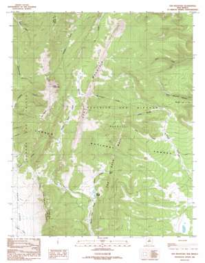
Ash Mountain Topo Map New Mexico
To zoom in, hover over the map of Ash Mountain
USGS Topo Quad 36105g2 - 1:24,000 scale
| Topo Map Name: | Ash Mountain |
| USGS Topo Quad ID: | 36105g2 |
| Print Size: | ca. 21 1/4" wide x 27" high |
| Southeast Coordinates: | 36.75° N latitude / 105.125° W longitude |
| Map Center Coordinates: | 36.8125° N latitude / 105.1875° W longitude |
| U.S. State: | NM |
| Filename: | o36105g2.jpg |
| Download Map JPG Image: | Ash Mountain topo map 1:24,000 scale |
| Map Type: | Topographic |
| Topo Series: | 7.5´ |
| Map Scale: | 1:24,000 |
| Source of Map Images: | United States Geological Survey (USGS) |
| Alternate Map Versions: |
Ash Mountain NM 1986, updated 1986 Download PDF Buy paper map Ash Mountain NM 1995, updated 1998 Download PDF Buy paper map Ash Mountain NM 2011 Download PDF Buy paper map Ash Mountain NM 2013 Download PDF Buy paper map |
| FStopo: | US Forest Service topo Ash Mountain is available: Download FStopo PDF Download FStopo TIF |
1:24,000 Topo Quads surrounding Ash Mountain
> Back to 36105e1 at 1:100,000 scale
> Back to 36104a1 at 1:250,000 scale
> Back to U.S. Topo Maps home
Ash Mountain topo map: Gazetteer
Ash Mountain: Gaps
Windy Gap elevation 2925m 9596′Ash Mountain: Populated Places
McCrystal Place elevation 2635m 8645′Shuree elevation 2844m 9330′
Ash Mountain: Ridges
The Rock Wall elevation 3027m 9931′Ash Mountain: Streams
Shuree Creek elevation 2816m 9238′Ash Mountain: Summits
Ash Mountain elevation 3414m 11200′Little Costilla Peak elevation 3825m 12549′
Ash Mountain digital topo map on disk
Buy this Ash Mountain topo map showing relief, roads, GPS coordinates and other geographical features, as a high-resolution digital map file on DVD:


