Cerro Topo Map New Mexico
To zoom in, hover over the map of Cerro
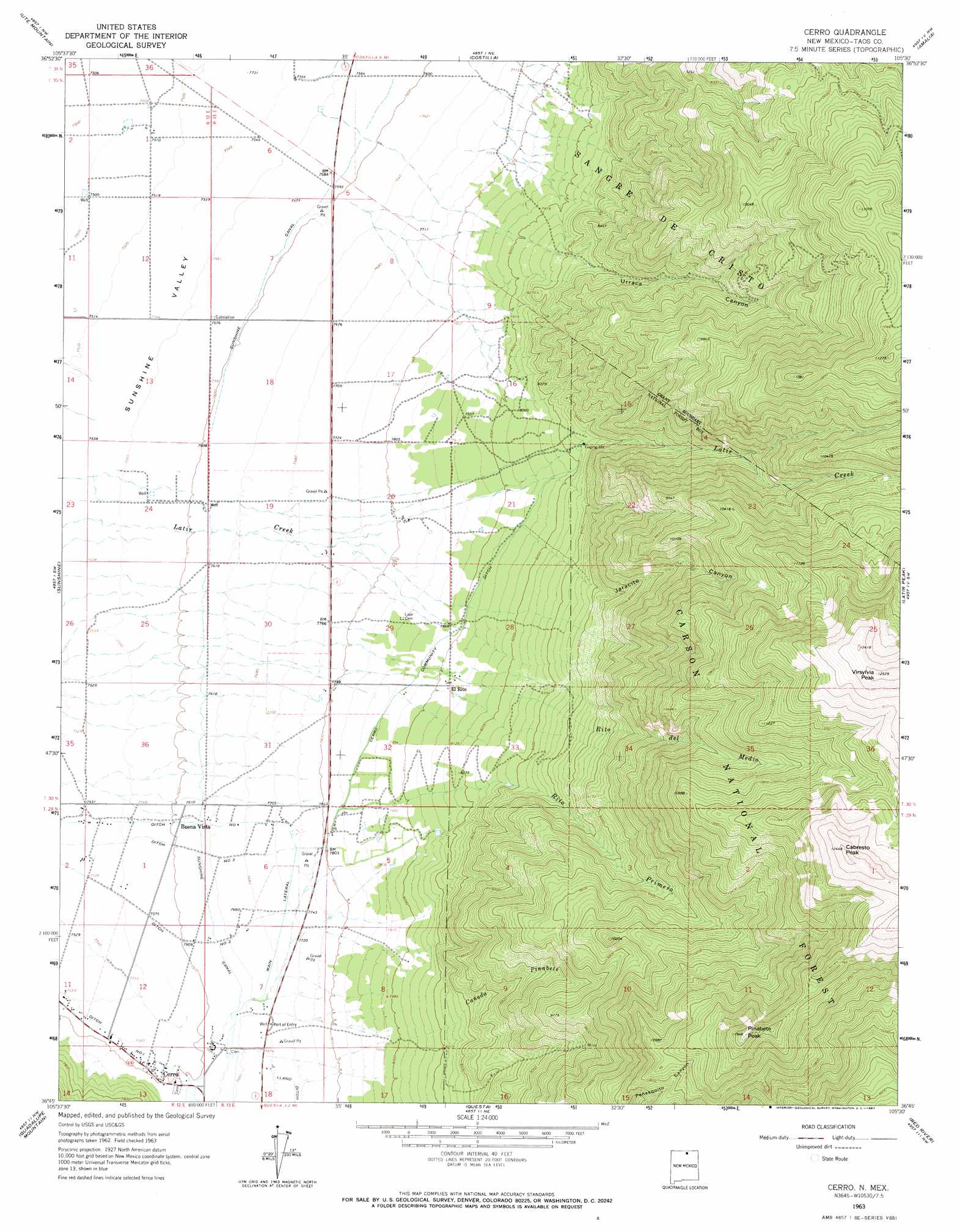
USGS Topo Quad 36105g5 - 1:24,000 scale
| Topo Map Name: | Cerro |
| USGS Topo Quad ID: | 36105g5 |
| Print Size: | ca. 21 1/4" wide x 27" high |
| Southeast Coordinates: | 36.75° N latitude / 105.5° W longitude |
| Map Center Coordinates: | 36.8125° N latitude / 105.5625° W longitude |
| U.S. State: | NM |
| Filename: | o36105g5.jpg |
| Download Map JPG Image: | Cerro topo map 1:24,000 scale |
| Map Type: | Topographic |
| Topo Series: | 7.5´ |
| Map Scale: | 1:24,000 |
| Source of Map Images: | United States Geological Survey (USGS) |
| Alternate Map Versions: |
Cerro NM 1963, updated 1967 Download PDF Buy paper map Cerro NM 1995, updated 1997 Download PDF Buy paper map Cerro NM 2011 Download PDF Buy paper map Cerro NM 2013 Download PDF Buy paper map Cerro NM 2017 Download PDF Buy paper map |
| FStopo: | US Forest Service topo Cerro is available: Download FStopo PDF Download FStopo TIF |
1:24,000 Topo Quads surrounding Cerro
Kiowa Hill |
Sky Valley Ranch |
Garcia |
Sanchez Reservoir |
La Valley |
La Segita Peaks Ne |
Ute Mountain |
Costilla |
Amalia |
Big Costilla Peak |
Cerro De La Olla |
Sunshine |
Cerro |
Latir Peak |
Comanche Point |
Tres Piedras Ne |
Guadalupe Mountain |
Questa |
Red River |
Red River Pass |
Cerro De Los Taoses |
Arroyo Hondo |
Arroyo Seco |
Wheeler Peak |
Eagle Nest |
> Back to 36105e1 at 1:100,000 scale
> Back to 36104a1 at 1:250,000 scale
> Back to U.S. Topo Maps home
Cerro topo map: Gazetteer
Cerro: Canals
Cerro Community Ditch elevation 2382m 7814′Community Ditch elevation 2430m 7972′
Main Lateral elevation 2348m 7703′
Number Four Ditch elevation 2318m 7604′
Number Three Ditch elevation 2330m 7644′
Number Two Ditch elevation 2320m 7611′
Sunshine Canal elevation 2323m 7621′
Cerro: Dams
Cabresto Lake Dam elevation 2882m 9455′Cerro: Mines
Esperanza Claim elevation 3158m 10360′Pinabete Canyon elevation 2955m 9694′
Revelation Manganese D Mine elevation 2621m 8599′
Sawmill Canyon Prospect elevation 3027m 9931′
Cerro: Populated Places
Buena Vista elevation 2328m 7637′Cerro elevation 2317m 7601′
El Rito elevation 2448m 8031′
Cerro: Post Offices
Cerro Post Office elevation 2317m 7601′Cerro: Reservoirs
Cabresto Lake elevation 2882m 9455′Cerro: Streams
Cañada Pinabete elevation 2329m 7641′Rito del Medio elevation 2426m 7959′
Rito Primero elevation 2390m 7841′
Cerro: Summits
Cabresto Peak elevation 3794m 12447′Pinabete Peak elevation 3637m 11932′
Cerro: Valleys
Jaracito Canyon elevation 2622m 8602′Urraca Canyon elevation 2502m 8208′
Cerro: Wells
10021 Water Well elevation 2321m 7614′10022 Water Well elevation 2316m 7598′
10026 Water Well elevation 2294m 7526′
10032 Water Well elevation 2352m 7716′
10051 Water Well elevation 2287m 7503′
10054 WAter Well elevation 2312m 7585′
10055 Water Well elevation 2402m 7880′
10108 Water Well elevation 2291m 7516′
10110 Water Well elevation 2313m 7588′
10111 Water Well elevation 2369m 7772′
10112 Water Well elevation 2328m 7637′
PUBSUP Water Well 1 elevation 2312m 7585′
Testhole R4 Water Well elevation 2320m 7611′
Water Well 1 elevation 2321m 7614′
Water Well 1 elevation 2290m 7513′
Water Well 2 elevation 2310m 7578′
Water Well 2 elevation 2287m 7503′
Water Well 3 elevation 2291m 7516′
Cerro digital topo map on disk
Buy this Cerro topo map showing relief, roads, GPS coordinates and other geographical features, as a high-resolution digital map file on DVD: