Cerro Del Grant Topo Map New Mexico
To zoom in, hover over the map of Cerro Del Grant
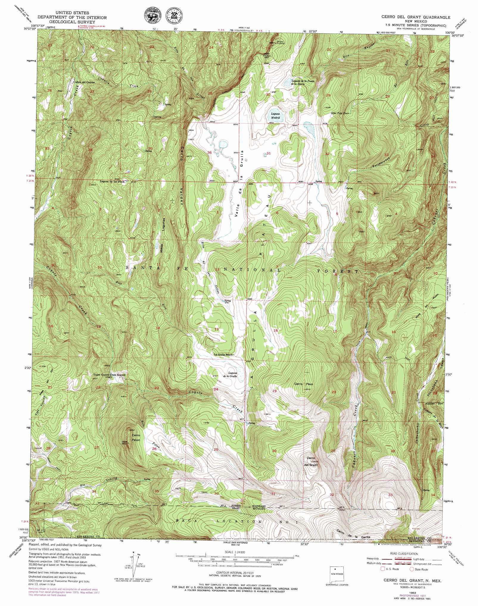
USGS Topo Quad 36106a5 - 1:24,000 scale
| Topo Map Name: | Cerro Del Grant |
| USGS Topo Quad ID: | 36106a5 |
| Print Size: | ca. 21 1/4" wide x 27" high |
| Southeast Coordinates: | 36° N latitude / 106.5° W longitude |
| Map Center Coordinates: | 36.0625° N latitude / 106.5625° W longitude |
| U.S. State: | NM |
| Filename: | o36106a5.jpg |
| Download Map JPG Image: | Cerro Del Grant topo map 1:24,000 scale |
| Map Type: | Topographic |
| Topo Series: | 7.5´ |
| Map Scale: | 1:24,000 |
| Source of Map Images: | United States Geological Survey (USGS) |
| Alternate Map Versions: |
Cerro Del Grant NM 1953, updated 1954 Download PDF Buy paper map Cerro Del Grant NM 1953, updated 1965 Download PDF Buy paper map Cerro Del Grant NM 1953, updated 1978 Download PDF Buy paper map Cerro Del Grant NM 2002, updated 2003 Download PDF Buy paper map Cerro del Grant NM 2011 Download PDF Buy paper map Cerro del Grant NM 2013 Download PDF Buy paper map Cerro del Grant NM 2017 Download PDF Buy paper map |
| FStopo: | US Forest Service topo Cerro del Grant is available: Download FStopo PDF Download FStopo TIF |
1:24,000 Topo Quads surrounding Cerro Del Grant
French Mesa |
Laguna Peak |
Echo Amphitheater |
Ghost Ranch |
Canjilon Se |
Gallina |
Arroyo Del Agua |
Youngsville |
Canones |
Abiquiu |
Nacimiento Peak |
Jarosa |
Cerro Del Grant |
Polvadera Peak |
Vallecitos |
Rancho Del Chaparral |
Seven Springs |
Valle San Antonio |
Valle Toledo |
Guaje Mountain |
San Miguel Mountain |
Jemez Springs |
Redondo Peak |
Bland |
Frijoles |
> Back to 36106a1 at 1:100,000 scale
> Back to 36106a1 at 1:250,000 scale
> Back to U.S. Topo Maps home
Cerro Del Grant topo map: Gazetteer
Cerro Del Grant: Areas
La Grulla Plateau elevation 3003m 9852′Cerro Del Grant: Benches
Mesa Lagunas elevation 2837m 9307′Cerro Del Grant: Cliffs
Cerro Valdez elevation 2959m 9708′Cerro Del Grant: Lakes
Laguna de la Sierra elevation 2948m 9671′Laguna de los Pinos elevation 2737m 8979′
Laguna Madrid elevation 2923m 9589′
Cerro Del Grant: Mines
Rey elevation 2311m 7582′Cerro Del Grant: Reservoirs
Champe Tank elevation 2897m 9504′Magogo Tank elevation 2912m 9553′
Cerro Del Grant: Springs
Barranquenos Spring elevation 2926m 9599′Cebolla Spring elevation 2793m 9163′
Flavjo Spring elevation 2900m 9514′
Grant Spring elevation 3081m 10108′
La Jara Spring elevation 2910m 9547′
Leche Spring elevation 2959m 9708′
Madrid Spring elevation 2978m 9770′
Ojito Palo Duro elevation 2848m 9343′
Pavo Spring elevation 3055m 10022′
Cerro Del Grant: Streams
Barrancones Creek elevation 2508m 8228′Cañada de la Mora elevation 2795m 9169′
Capulin Creek elevation 2237m 7339′
Rito Pelon elevation 2714m 8904′
Rito Seco elevation 2388m 7834′
Cerro Del Grant: Summits
Cerro del Grant elevation 3174m 10413′Cerro Pavo elevation 3144m 10314′
Cerro Pelon elevation 2992m 9816′
Mesa del Medio elevation 2959m 9708′
Mesa del Ojo elevation 2848m 9343′
Cerro Del Grant: Swamps
Laguna de la Grulla elevation 2968m 9737′Cerro Del Grant: Valleys
Valle de la Grulla elevation 2922m 9586′Cerro Del Grant digital topo map on disk
Buy this Cerro Del Grant topo map showing relief, roads, GPS coordinates and other geographical features, as a high-resolution digital map file on DVD: