Tafoya Canyon Topo Map New Mexico
To zoom in, hover over the map of Tafoya Canyon
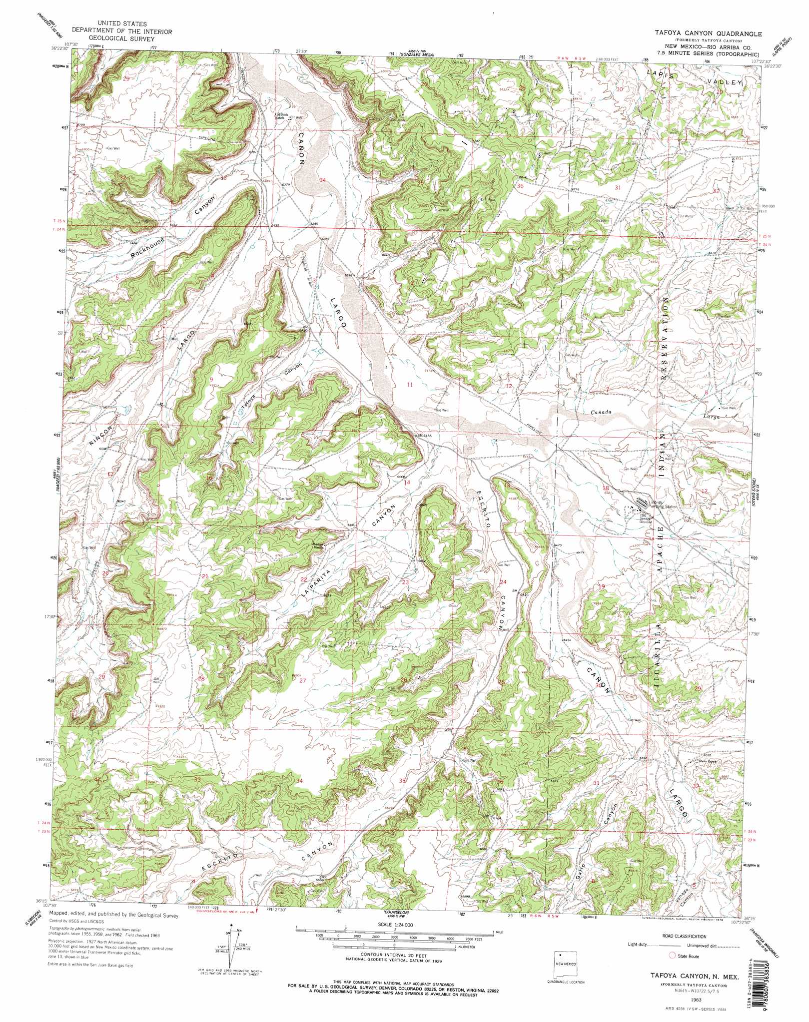
USGS Topo Quad 36107c4 - 1:24,000 scale
| Topo Map Name: | Tafoya Canyon |
| USGS Topo Quad ID: | 36107c4 |
| Print Size: | ca. 21 1/4" wide x 27" high |
| Southeast Coordinates: | 36.25° N latitude / 107.375° W longitude |
| Map Center Coordinates: | 36.3125° N latitude / 107.4375° W longitude |
| U.S. State: | NM |
| Filename: | o36107c4.jpg |
| Download Map JPG Image: | Tafoya Canyon topo map 1:24,000 scale |
| Map Type: | Topographic |
| Topo Series: | 7.5´ |
| Map Scale: | 1:24,000 |
| Source of Map Images: | United States Geological Survey (USGS) |
| Alternate Map Versions: |
Tayfoya Canyon NM 1963, updated 1965 Download PDF Buy paper map Tafoya Canyon NM 1963, updated 1978 Download PDF Buy paper map Tafoya Canyon NM 2010 Download PDF Buy paper map Tafoya Canyon NM 2013 Download PDF Buy paper map Tafoya Canyon NM 2017 Download PDF Buy paper map |
1:24,000 Topo Quads surrounding Tafoya Canyon
Fresno Canyon |
Gould Pass |
Santos Peak |
Vigas Canyon |
Pine Lake |
Thompson Mesa |
Smouse Mesa |
Gonzales Mesa |
Lapis Point |
Schmitz Ranch |
Crow Mesa West |
Crow Mesa East |
Tafoya Canyon |
Otero Store |
Billy Rice Canyon |
Lybrook Nw |
Lybrook |
Counselor |
Tancosa Windmill |
Five Lakes Canyon Nw |
Fire Rock Well |
Lybrook Se |
Mule Dam |
Deer Mesa |
Taylor Ranch |
> Back to 36107a1 at 1:100,000 scale
> Back to 36106a1 at 1:250,000 scale
> Back to U.S. Topo Maps home
Tafoya Canyon topo map: Gazetteer
Tafoya Canyon: Springs
Otero Spring elevation 1996m 6548′Tafoya Canyon: Streams
Cañada Larga elevation 1962m 6437′Tafoya Canyon: Valleys
Escrito Canyon elevation 1962m 6437′Gallo Canyon elevation 1991m 6532′
Haynes Canyon elevation 2039m 6689′
Johnson Canyon elevation 1988m 6522′
La Parita Canyon elevation 1958m 6423′
Lapis Valley elevation 1988m 6522′
Rincon Largo elevation 1945m 6381′
Rockhouse Canyon elevation 1940m 6364′
Tafoya Canyon elevation 1948m 6391′
Venado Canyon elevation 2000m 6561′
Tafoya Canyon: Wells
Lindrith 1 Water Well elevation 1982m 6502′Lindrith 2 Water Well elevation 1984m 6509′
Lindrith 3 Water Well elevation 1978m 6489′
Lindrith H Water Well elevation 1988m 6522′
Tafoya Canyon digital topo map on disk
Buy this Tafoya Canyon topo map showing relief, roads, GPS coordinates and other geographical features, as a high-resolution digital map file on DVD: