Smouse Mesa Topo Map New Mexico
To zoom in, hover over the map of Smouse Mesa
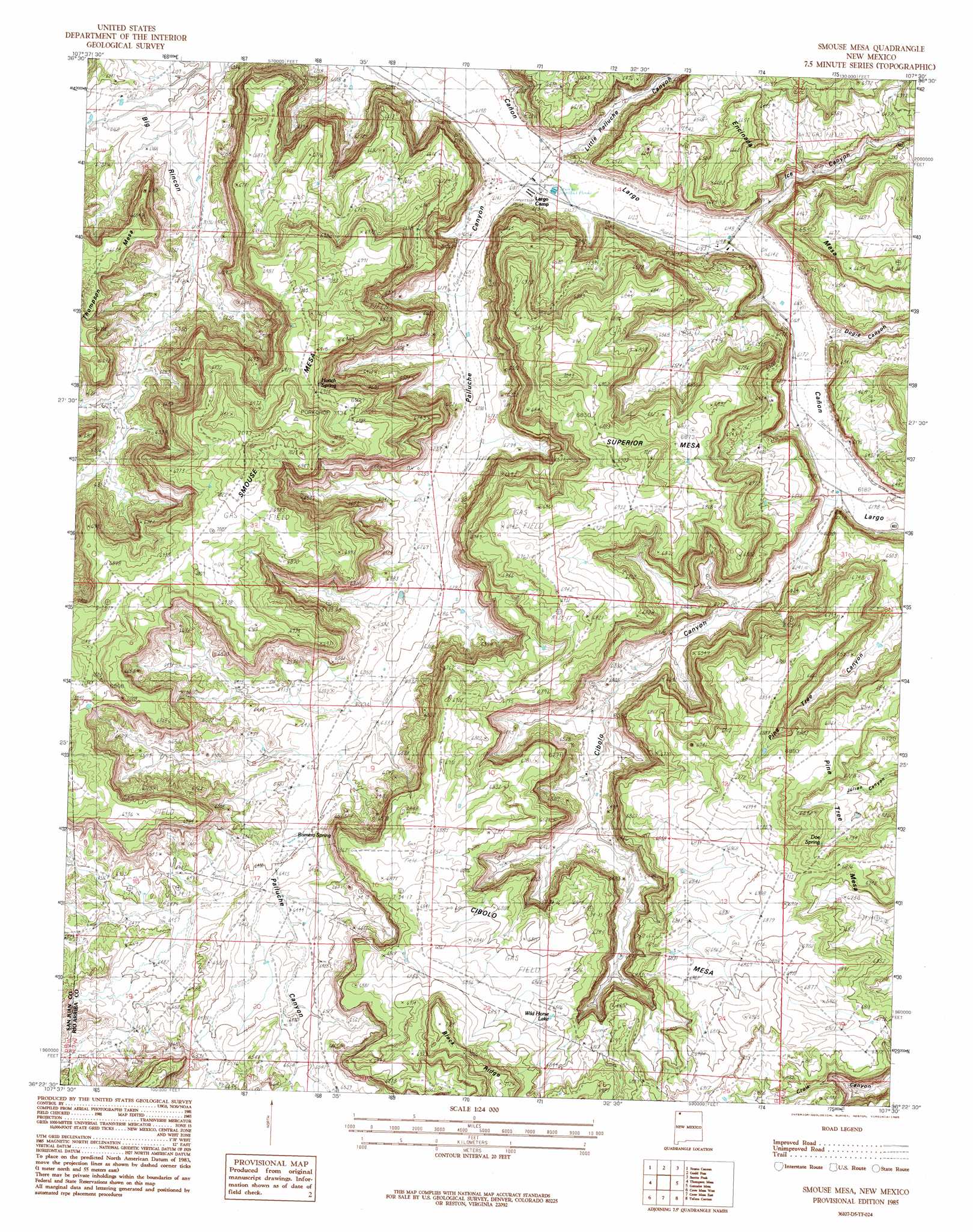
USGS Topo Quad 36107d5 - 1:24,000 scale
| Topo Map Name: | Smouse Mesa |
| USGS Topo Quad ID: | 36107d5 |
| Print Size: | ca. 21 1/4" wide x 27" high |
| Southeast Coordinates: | 36.375° N latitude / 107.5° W longitude |
| Map Center Coordinates: | 36.4375° N latitude / 107.5625° W longitude |
| U.S. State: | NM |
| Filename: | o36107d5.jpg |
| Download Map JPG Image: | Smouse Mesa topo map 1:24,000 scale |
| Map Type: | Topographic |
| Topo Series: | 7.5´ |
| Map Scale: | 1:24,000 |
| Source of Map Images: | United States Geological Survey (USGS) |
| Alternate Map Versions: |
Smouse Mesa NM 1985, updated 1985 Download PDF Buy paper map Smouse Mesa NM 2010 Download PDF Buy paper map Smouse Mesa NM 2013 Download PDF Buy paper map |
1:24,000 Topo Quads surrounding Smouse Mesa
Blanco |
Cutter Canyon |
Delgadito Mesa |
Fourmile Canyon |
Gobernador |
Huerfanito Peak |
Fresno Canyon |
Gould Pass |
Santos Peak |
Vigas Canyon |
Huerfano Trading Post |
Thompson Mesa |
Smouse Mesa |
Gonzales Mesa |
Lapis Point |
Blanco Trading Post |
Crow Mesa West |
Crow Mesa East |
Tafoya Canyon |
Otero Store |
Kimbeto |
Lybrook Nw |
Lybrook |
Counselor |
Tancosa Windmill |
> Back to 36107a1 at 1:100,000 scale
> Back to 36106a1 at 1:250,000 scale
> Back to U.S. Topo Maps home
Smouse Mesa topo map: Gazetteer
Smouse Mesa: Lakes
Wild Horse Lake elevation 2076m 6811′Smouse Mesa: Springs
Doe Spring elevation 2070m 6791′Hooch Spring elevation 2049m 6722′
Romero Spring elevation 1957m 6420′
Smouse Mesa: Streams
Palluche Wash elevation 1865m 6118′Smouse Mesa: Summits
Cibolo Mesa elevation 2123m 6965′Smouse Mesa elevation 2172m 7125′
Superior Mesa elevation 2104m 6902′
Smouse Mesa: Valleys
Cibolo Canyon elevation 1885m 6184′Dogie Canyon elevation 1878m 6161′
Ice Canyon elevation 1877m 6158′
Little Palluche Canyon elevation 1865m 6118′
Palluche Canyon elevation 1857m 6092′
Smouse Mesa: Wells
Largo 2 Water Well elevation 1866m 6122′Largo I Water Well elevation 1865m 6118′
Pinetree Water Well elevation 2114m 6935′
Smouse Mesa digital topo map on disk
Buy this Smouse Mesa topo map showing relief, roads, GPS coordinates and other geographical features, as a high-resolution digital map file on DVD: