Vigas Canyon Topo Map New Mexico
To zoom in, hover over the map of Vigas Canyon
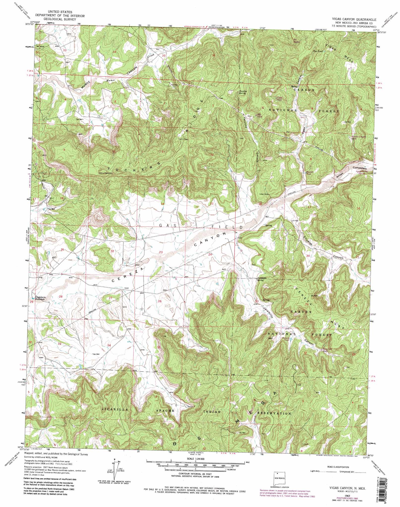
USGS Topo Quad 36107e3 - 1:24,000 scale
| Topo Map Name: | Vigas Canyon |
| USGS Topo Quad ID: | 36107e3 |
| Print Size: | ca. 21 1/4" wide x 27" high |
| Southeast Coordinates: | 36.5° N latitude / 107.25° W longitude |
| Map Center Coordinates: | 36.5625° N latitude / 107.3125° W longitude |
| U.S. State: | NM |
| Filename: | o36107e3.jpg |
| Download Map JPG Image: | Vigas Canyon topo map 1:24,000 scale |
| Map Type: | Topographic |
| Topo Series: | 7.5´ |
| Map Scale: | 1:24,000 |
| Source of Map Images: | United States Geological Survey (USGS) |
| Alternate Map Versions: |
Vigas Canyon NM 1963, updated 1966 Download PDF Buy paper map Vigas Canyon NM 1963, updated 1975 Download PDF Buy paper map Vigas Canyon NM 1963, updated 1983 Download PDF Buy paper map Vigas Canyon NM 1995, updated 1997 Download PDF Buy paper map Vigas Canyon NM 2011 Download PDF Buy paper map Vigas Canyon NM 2013 Download PDF Buy paper map Vigas Canyon NM 2017 Download PDF Buy paper map |
| FStopo: | US Forest Service topo Vigas Canyon is available: Download FStopo PDF Download FStopo TIF |
1:24,000 Topo Quads surrounding Vigas Canyon
Navajo Dam |
Gomez Ranch |
Espinosa Ranch |
Bixler Ranch |
John Mills Lake |
Delgadito Mesa |
Fourmile Canyon |
Gobernador |
Leandro Canyon |
Cement Lake |
Gould Pass |
Santos Peak |
Vigas Canyon |
Pine Lake |
Leavry Canyon |
Smouse Mesa |
Gonzales Mesa |
Lapis Point |
Schmitz Ranch |
Ojito |
Crow Mesa East |
Tafoya Canyon |
Otero Store |
Billy Rice Canyon |
Lindrith |
> Back to 36107e1 at 1:100,000 scale
> Back to 36106a1 at 1:250,000 scale
> Back to U.S. Topo Maps home
Vigas Canyon topo map: Gazetteer
Vigas Canyon: Arroyos
Arroyo Campanero elevation 2036m 6679′Vigas Canyon: Dams
Encino Detention Dam Number 85 elevation 2086m 6843′Vigas Canyon: Lakes
Candelaria Waterhole elevation 1957m 6420′Vigas Canyon: Reservoirs
BS Tank elevation 2184m 7165′Deer Tank elevation 2237m 7339′
Vigas Canyon: Ridges
Tuckers Ridge elevation 2276m 7467′Vigas Canyon: Springs
Agua Bonito Spring elevation 2045m 6709′Jaramillo Spring elevation 2043m 6702′
Tecolote Spring elevation 2192m 7191′
Vigas Spring elevation 2138m 7014′
Vigas Canyon: Summits
B S Mesa elevation 2245m 7365′Cereza Mesa elevation 2211m 7253′
Jaramillo Mesa elevation 2248m 7375′
Vigas Canyon: Valleys
Arroyo Compañero elevation 2013m 6604′Cereza Canyon elevation 2013m 6604′
Ciruelas Canyon elevation 2020m 6627′
Jaramillo Canyon elevation 1990m 6528′
Tecolote Canyon elevation 2013m 6604′
Vigas Canyon elevation 2027m 6650′
Vigas Canyon: Wells
L Velarde Water Well elevation 2030m 6660′S J 27-5 1 Water Well elevation 2012m 6601′
Vigas Canyon digital topo map on disk
Buy this Vigas Canyon topo map showing relief, roads, GPS coordinates and other geographical features, as a high-resolution digital map file on DVD: