Cement Lake Topo Map New Mexico
To zoom in, hover over the map of Cement Lake
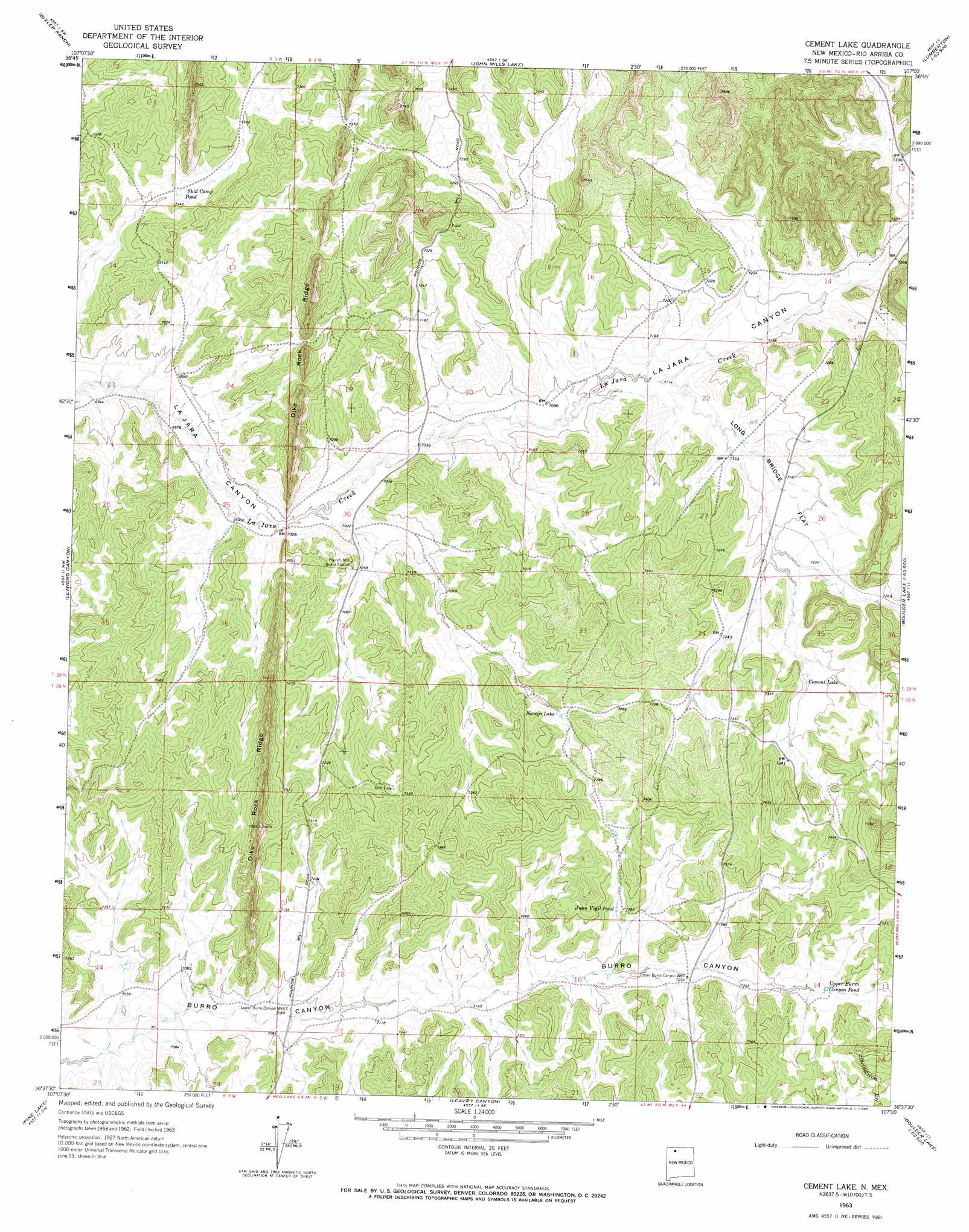
USGS Topo Quad 36107f1 - 1:24,000 scale
| Topo Map Name: | Cement Lake |
| USGS Topo Quad ID: | 36107f1 |
| Print Size: | ca. 21 1/4" wide x 27" high |
| Southeast Coordinates: | 36.625° N latitude / 107° W longitude |
| Map Center Coordinates: | 36.6875° N latitude / 107.0625° W longitude |
| U.S. State: | NM |
| Filename: | o36107f1.jpg |
| Download Map JPG Image: | Cement Lake topo map 1:24,000 scale |
| Map Type: | Topographic |
| Topo Series: | 7.5´ |
| Map Scale: | 1:24,000 |
| Source of Map Images: | United States Geological Survey (USGS) |
| Alternate Map Versions: |
Cement Lake NM 1963, updated 1966 Download PDF Buy paper map Cement Lake NM 2010 Download PDF Buy paper map Cement Lake NM 2013 Download PDF Buy paper map Cement Lake NM 2017 Download PDF Buy paper map |
1:24,000 Topo Quads surrounding Cement Lake
Bancos Mesa |
Carracas Canyon |
Wirt Canyon |
Dulce |
Monero |
Espinosa Ranch |
Bixler Ranch |
John Mills Lake |
Cordova Canyon |
Horse Lake |
Gobernador |
Leandro Canyon |
Cement Lake |
Cedar Canyon |
Apache Mesa |
Vigas Canyon |
Pine Lake |
Leavry Canyon |
Los Indios Canyon |
Pounds Mesa |
Lapis Point |
Schmitz Ranch |
Ojito |
Canada Ojitos |
Llaves |
> Back to 36107e1 at 1:100,000 scale
> Back to 36106a1 at 1:250,000 scale
> Back to U.S. Topo Maps home
Cement Lake topo map: Gazetteer
Cement Lake: Dams
La Jara Lake Dam elevation 2233m 7326′Cement Lake: Flats
Long Bridge Flat elevation 2185m 7168′Cement Lake: Populated Places
Pounds (historical) elevation 2167m 7109′Cement Lake: Reservoirs
Cement Lake elevation 2219m 7280′Juan Vigil Pond elevation 2209m 7247′
Navajo Lake elevation 2201m 7221′
Skid Camp Pond elevation 2171m 7122′
Upper Burro Canyon Pond elevation 2231m 7319′
Cement Lake: Ridges
Dike Rock Ridge elevation 2232m 7322′Cement Lake: Valleys
Telephone Canyon elevation 2217m 7273′Cement Lake: Wells
Bia 16 Water Well elevation 2205m 7234′Harrison Elote Water Well elevation 2180m 7152′
Lower Burro Canyon Well elevation 2160m 7086′
Range Unit 38 Water Well elevation 2203m 7227′
Red Lakes Water Well elevation 2161m 7089′
Upper Burro Canyon Well elevation 2205m 7234′
Cement Lake digital topo map on disk
Buy this Cement Lake topo map showing relief, roads, GPS coordinates and other geographical features, as a high-resolution digital map file on DVD: